I absolutely love Joshua Trees. Much like the Saguaros are iconic to the Sonoran Desert, the Joshua Trees are iconic symbols of the Mojave Desert and it’s too easy to imagine human characteristics in both. Every time I pull into an area with Joshua Trees it makes me smile and feel happy. Interestingly, Joshua Trees aren’t really trees at all, but rather a tree-like member of the yucca family. They may have been given their name by early Mormon pioneers who thought they resembled the Biblical Joshua with his arms raised.
It is believed that people have been living in the region of Joshua Tree National Park for 10,000 years. The first people of European descent who laid eyes on the area were with Spaniard Pedro Fages who was pursuing Native Americans who had “escaped” the mission in San Diego. After the Mexican-American War, American settlers started moving in, building ranches and doing some small-scale mining. Franklin Roosevelt protected the area as Joshua Tree National Monument in 1936 and it became a National Park in 1994. The park covers 1,242 square miles - slightly larger than the state of Rhode Island.
I’ve visited Joshua Tree National Park several times before, but always in the middle of summer when it was boiling hot out. We might get out and take some photos, but long hikes were pretty much out of the question. I was really happy to get there this past spring when it was cool and pleasant and I could get out on the trails. I hiked the Short Loop Trail from Black Rock Campground, Ryan Mountain, and the Lost Horse Mine Loop among others and they were all fantastic. Joshua Tree National Park is a special place and while it doesn’t get the hype of our other western National Parks, it’s definitely worth a visit. I can’t wait to return. I hope you enjoy these photos from beautiful Joshua Tree National Park.
The Channel Islands are an eight island archipelago off the coast of Southern California and five of these islands make up Channel Islands National Park. The waters surrounding these islands are also protected as a National Marine Sanctuary. The Channel Islands were created by tectonic forces 5 million years ago and have always been islands, although they were closer to the mainland during the last ice age when the sea levels were lower. Because of their isolation, the islands are home to several endemic species of plants and animals meaning those found nowhere else on Earth.
People have inhabited these islands for a very long time. In fact the oldest human remains ever found in North America, dating back 13,000 years, were discovered on Santa Barbara Island in 1959. In more recent times, the northern islands were home to different bands of the Chumash people while the southern islands were inhabited by the Tongva. Juan Cabrillo observed the islands on his 1542 voyage up the coast and in more modern times the islands were used to raise sheep and cattle. They were protected as a National Park in 1980.
I was unfortunately only able to visit one of the islands in Channel Islands National Park during my stay, but Santa Cruz is the biggest and most accessible and made for a wonderful visit. I stayed in the campground at Scorpion Ranch for three nights and was able to hike to Cavern Point, Smuggler’s Cove, Potato Harbor and the incredible Montañon Ridge. For the last two days I was on the island, there were only 19 other people there which made for a peaceful and incredible stay. It was hard to believe that we were only an hour car ride and an hour ferry ride from the second largest city in the country, but it sure was nice to be there. I can’t wait to go back again. I hope you enjoy these photos from Channel Islands National Park.
Hello Everyone,
It’s been another busy week here in Southern California. I spent half of the week out on Santa Cruz Island in Channel Islands National Park which was an absolutely wonderful experience. When I returned to the mainland, I made my way south to Los Angeles and have been here since, catching up with old friends and visiting some old haunts and some new places as well. I haven’t traveled far this week, so this probably won’t be a particularly long post, but it’s been nice to get some hiking in and the sun is finally shining again.
Last Wednesday, I packed up my backpack and hopped on The Islander in Ventura for the one our crossing to Scorpion Ranch on Santa Cruz Island. The water was rough, but it wasn’t too bad and thankfully it wasn’t a long voyage. When we arrived, we met briefly with the ranger and then headed off to set up camp. It had been raining all night and most of the morning, but the sun was out and it’s always easier to set up a tent in the sun than in the rain. The campground was pretty soggy and we had been warned about branches falling from the eucalyptus trees, so choosing a good spot to set up was essential. After getting my tent up and ready, I decided to use whatever sunshine was left to hike up to the Potato Harbor overlook. This was only about a 4 mile round-trip hike, but it was really muddy on the trail. The mud had a high clay content too, so it stuck to my shoes and it caked on so thick that it looked like I was wearing snowshoes. I made it to the overlook which was absolutely stunning and on the way there I saw several endemic Santa Cruz grey foxes. These foxes have evolved to be much smaller than their mainland cousins, and growing up on an island with no predators, they’re also very friendly. I loved watching them wander around the island and found they made me smile every time I saw them.
After having my lunch at the overlook, I could see the rain coming towards me across the ocean so I started to make my way back to camp. Unfortunately the rain caught up with me before I got there, but worse it turned the clay trail into a slick downhill path. I almost made it back to camp without falling. In fact, I could see the campground from where I fell, but my feet just went out from under me and I landed pretty hard on my shoulder. While I didn’t do any damage and didn’t even get a bruise, it hurt for a few days and I didn’t have any pain killers with me in my pack. I wasn’t happy about it, but it could’ve been worse, too. I headed back to my tent and caught a nap while the rain kept pounding down. It eased up in the evening and hasn’t been back since. That night I ate the first freeze-dried meal I’ve had in many years. When I was a teenager, I spent two summers working at a Boy Scout backpacking camp in Virginia and we ate freeze dried food most of the time. It’s come a long way since I tried it last and I must admit that it was actually pretty tasty. After dinner, the sun went down and there wasn’t much to do so I slipped into my tent and called it an early night…
Hey y’all. I just wanted to share a few of my favorite shots from my time on the North Rim of the Grand Canyon. I’m doing this as a Snapshots post instead of an In Focus post because I’ll make one for all of Grand Canyon later this summer, but with any luck I will get down to Phantom Ranch between now and then, making it somewhat more complete. But I promised you some Grand Canyon photos before I transitioned to more recent California shots next week, so here you go. Enjoy!!
Organ Pipe Cactus National Monument was one of the top spots on my list of places to visit during my time in Arizona. It’s a remote park, located two hours from anywhere and right on the U.S./Mexican border, but it’s the only place in the country that you can find naturally occurring organ pipe cactus. In addition to these beauties, there are so many other species of cactus and desert plants as well which has led to this region also being named a part of UNESCO’s International Biosphere Reserve.
Organ Pipe Cactus was made a National Monument by Franklin Roosevelt back in 1937. A special act was passed to allow mining in the area during World War II, an act which sadly wasn’t repealed until 1976. The park’s remote location on the Mexican border used to bring both drug runners and human smugglers through the area, making this America’s most dangerous park. This danger is memorialized in the Kris Eggle Visitors Center which was named for a park ranger who was killed protecting visitors from drug smugglers in 2002. In the wake of his death, the border was reinforced and I felt safe there during my stay.
It was unbelievably hot when I arrived on an afternoon in late April. So hot that I couldn’t actually do anything but hover in the shade of the restroom and wait until the sun started to go down. I did enjoy a wonderful evening hike and an early morning one the following day as well. The area is beautiful and it was great to see the Organ Pipes in their native habitat. It was definitely just a one night stop, but I’m very glad I went. I hope you enjoy these photos from Organ Pipe Cactus National Monument.
Construction on Fort Bowie began in 1862 after two separate confrontations between the United States Army and the Chiricahua Apache. The fort was erected to protect the Apache Pass through the mountains and Apache Springs, a vital water source in the area. Six years later a more substantial fort was built just up the hill from the original fort and would be in service until 1894. The Apache Wars would end in 1886 with the surrender of Chiricahua leader, Geronimo, and the removal of the Chiricahua from the area. As you may remember from a recent post, the U.S. Army was aided in this endeavor by the White Mountain Apache scouts based in Fort Apache to the north who were the sworn enemies of the Chiricahua.
The fort today is a mere remnant of what it once was. The adobe walls have all but melted back into the surrounding desert and the stone foundations and a few odds and ends are all that is left. This park is unique in that it is a “hike-in” park, meaning the only way to visit it is by hiking the 1.5 miles from the parking lot up to Apache Pass. This walk takes you past the old stagecoach stop ruins, the cemetery, an old Apache village, Apache Spring and up to the pass where the fort is located. While the rangers at the park will provide access for people with disabilities, this walk is an amazing way to get a feel for the remoteness of the fort and the isolation the men who were once stationed there must have felt. I was definitely glad I visited in the winter months as I’m sure making this walk in the summer is quite hot and dusty. I was definitely glad I finally made it out to Fort Bowie as it’s been on my to-do list for many years now and I’m glad I finally got there. I hope you enjoy these photos from Fort Bowie National Historic Park.
Father Eusebio Francisco Kino established the Mission San Cayetano de Tumacácori on the east side of the Santa Cruz River in January of 1691, making this the oldest mission site in what is now Arizona. The name “Tumacácori” is an English bastardization of a Spanish interpretation of an O’odham (Pima) word, the meaning of which has been lost. It is how the native people referred to this region. After years of violence at the hands of the Spanish, the O’odham people rose up in the Pima Revolt of 1751. Laying blame on the abuse of the Jesuits missionaries, they were pardoned by the colonial governor and the Jesuits would be expelled from the colonies beginning in 1757. The mission was moved across the river and renamed Mission San José de Tumacácori and the first actual church was built on this new site.
Franciscans would try and pick up where the Jesuits left off and in 1800 they began work on an ambitious new church, trying to match the majesty of Mission San Xavier del Bac to the north (a photo of which appears at the very bottom of this post). The church was never fully completed as the missions were closed when the Mexicans won their independence in 1821. Today, the mission is a part of Tumacácori National Historical Park and a visit is a must when you’re in the area. You can learn more about the O’odham people, the Spanish missionaries and colonial life in the missions and it’s a very cool place for a wander.
There may be no more iconic plant in the United States than the stately and stoic saguaro cactus. These beautiful cacti can grow up to 40’ tall and live to be 150 years old. They won’t start growing arms until they are 75 years old and some will grow many arms in their lives. Most of the natural habitat of the saguaro is in the Sonoran Desert which straddles the U.S./Mexico border.
In 1933, President Herbert Hoover designated Saguaro National Monument which we now call the Rincon Mountain District of the park. In 1961, John F. Kennedy added the Tucson Mountain District to the Monument and in 1994 these two tracts were combined into Saguaro National Park.
Chiricahua National Monument in southeastern Arizona preserves a magical landscape created by a 27 million year old volcanic eruption. The lava hardened into rhyolite and erosion has carved out a wonderland of rock spires, balanced rocks and hoodoos. This little visited park site is truly spectacular and definitely worth a detour.
I arrived in the park late in the day so I didn’t have a ton of time to explore. After a quick stop at the Visitor Center, I made my way all the way up to Masai Point at the end of the 8 mile scenic drive and did the short nature loop there to get a good overview of the area. Then I set off on the magnificent 3.3 mile Echo Canyon/Hailstone/Ed Riggs loop trail which was really fantastic. When I finished this hike, the sun was on its way down and I enjoyed the glow on the rocks as I made my way back down the hill and on down the road.
While I was only in Chiricahua for a few hours, I really enjoyed my stay and look forward to returning again in the future. I hope you enjoy these photos from beautiful Chiricahua National Monument.
Hello Everyone! Happy August to you! It’s been an intensely busy few weeks out here on the road and I have barely had time to think, much less right a blog post. These last few weeks I’ve been on a mad dash around the Sierra Nevada Mountains and through the desert and it has been really great to be back in some of my favorite places. I’ve had good groups with me who have been supportive and enthusiastic, and I’ve been having a lot of fun with them. It’s monsoon season out in the desert, so rain clouds have been a constant companion, but the desert needs all the rain it can get and I’ve been able to work around them for the most part. Temperatures have soared as high as 114° out here and I’ve been doing my best to stay hydrated and healthy in the extreme conditions. All of that being said, it’s been a heck of a few weeks as I’ve spent most of it on the kind of trip I cut my teeth on many years ago. It’s always good to get back to your roots now and again.
When last I wrote, I was headed off on a 5 day walking tour in the mountains. The Wawona Fire was blazing in Yosemite, so we had to make adjustments to make it work. We still got into the Valley, but it was quite hazy and the air quality was poor. We made up for it with a hike out at Hetch Hetchy and a hike up Lembert Dome in the high country. It wasn’t perfect, but it was the best I could do and my group was very appreciative that they could at least see the highlights of the park. From there we headed out to Mammoth for the night.
The next day we hiked out and around Convict Lake, a first for me. It’s always nice to check out some new places and this trip had a few new spots in store for me. Convict Lake gets its name from a standoff between a local posse and a group of 29 convicts who had escaped from the prison in Carson City. It was a beautiful place for a walk and my group enjoyed a nice swim afterwards while I pulled the van around. From there we made our way north to the South Tufa area of Mono Lake. Mono Lake has several inlets but no outlets, making it one of the saltier lakes in the country as the water evaporates and the minerals remain. Natural springs under the lake percolate calcium rich water which deposits as calcium carbonate, leaving fascinating formations called Tufa Pinnacles. After some time there, we headed north again to the shores of beautiful Lake Tahoe. There was music, beer and food trucks at the public beach, so we spent our evening there – swimming in the lake and enjoying the show. It was a heck of a way to spend the last evening of our trip. We hiked to the postcard-perfect Echo Lake the next morning before returning to San Francisco.
I had a couple of days to get ready for my next trip and then made a beeline for Los Angeles where it would begin
Hello Everyone! I hope all of my American readers had a fabulous 4th of July. I spent mine in Yosemite National Park, which is a beautiful tribute to so much of what’s right with this country. Ken Burns was definitely onto something when he called our national parks “America’s greatest idea”. This country has had its ups and downs and the pendulum continues to swing, but I’m sure you know by now how passionate I am about our national parks and public lands in general. While there were definitely no fireworks allowed anywhere in the vicinity of Yosemite do to extreme drought and fire hazards, I was happy to spend some of the day in the shadow of the mountain known as Liberty Cap – it seemed quite fitting.
Since I am back to work and will be incredibly busy these next few months, these updates are going to come sporadically throughout the summer and early fall. During the last few years, I’ve tried to get them out pretty religiously on Wednesdays with an excellent success rate, but when I’m working it’s a different story. I’m slowly starting to shake the rust off from three years without guiding a tour and I’ve definitely been enjoying being back on the road and being back on payroll. It’s always good to see my accounts rolling up instead of down. I’ve also loved being back in front of a group, sharing my passion for nature and history and sharing travel stories and laughs over dinner and drinks. I have strangely been asked on two of my first four trips to give a brief overview of the American Civil War. Neither was brief, but I like to think they have a significantly better idea of what the war was about.
I’ve been really hoping to have one trip go off without a hitch as most of my trips did for many years before the pandemic. I’ve always been good at covering my bases so that even when things go wrong, most of my passengers will never know the difference. That’s been hard so far this season, and this current trip was no different. I only had four passengers scheduled on this current trip to Yosemite, but only two showed up on our first night together. Thankfully the other two at least left word as to where they were and by the evening of the second day I had all my ducklings gathered ‘round me. This was another 5 day hiking tour to Yosemite and the weather really couldn’t have been better. It was in the mid-60s to low-70s all week and not a cloud in the sky – perfect Yosemite hiking weather. The snow-melt-fed waterfalls are still going strong and the wildflowers are in full bloom. Once I had all of my passengers with me, I could tell we were in for a wonderful week.
And a wonderful week it was. On Sunday we went for lunch at the Iron Door Saloon, the oldest saloon in California dating back to 1852. Then we went out and hiked to see the giant sequoias, the largest living things on earth. Spending time among the sequoias is always humbling and awe-inspiring. When Jesus walked the earth, some of these trees were already a thousand years old.
Monday found us on the Mist Trail, hiking up 1600’ past the beautiful Vernal and Nevada Falls. This is a heavily traveled route and because of that is one I haven’t hiked in many years. I prefer to spend my time in Yosemite in quieter corners of the park. It has been nice to revisit this hike this season as it was the very first hike I ever did in Yosemite, 22 years ago when I was on my training trip to become a guide.
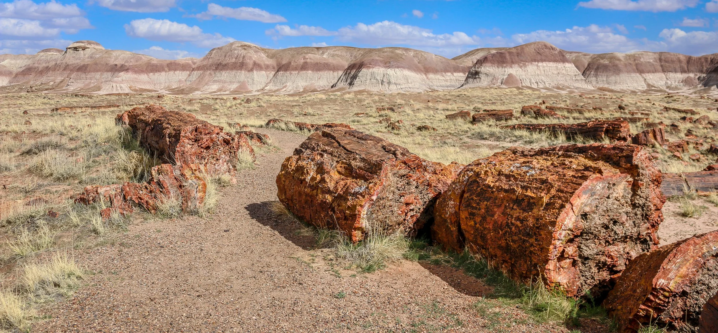
Petrified Forest National Park in eastern Arizona contains a beautiful collection of petrified wood and also includes the Painted Desert, Blue Mounds and an old stretch of Route 66. It’s a park best explored by car, but you won’t really appreciate it unless you get out and hike out into the wilderness. Petrified Forest was designated a National Monument back in 1906 and was upgraded to a National Park in 1962. I enjoyed my visit to the park and hope you enjoy these photos I took exploring the Petrified Forest.