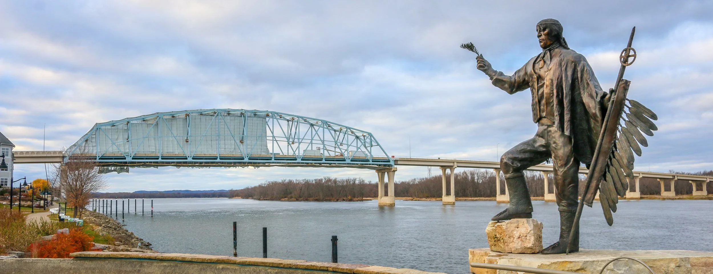
When Europeans first made their way up the Mississippi River, these lands were occupied by the Mdewakanton Dakota people who were led by Chief Wa-pa-shaw. The area was settled in 1826 and officially recognized after the Treaty of Prairie du Chien was signed in 1830. The fledgling town was named after the Chief as “Wabasha” and is now one of the oldest towns on the Upper Mississippi River. The early town’s economy was based on shipping, trading, lumber and flour and there was also a clamming industry and a button factory which utilized the discarded clam shells. Today, Wabasha is still undeniably a river town, but has made tourism a major economic interest - especially with the addition of the National Eagle Center. It’s probably most famous in recent times as the setting, though not the filming location, of the movie Grumpy Old Men. All of that being said, it would be easy to just blow on past Wabasha as it is just a small town of 2,500 or so people, but you’d be missing a real gem on Minnesota’s stretch of the mighty Mississippi. The historic buildings, the awesome statue of Chief Wabasha and the beautiful river setting combine with friendly people and some wonderful small businesses to make Wabasha a charming destination. Be sure you stop by Hoppy Girl Brewing Company while you’re there to taste some of the state’s best microbrews in one of its smallest and friendliest breweries. I had a wonderful visit to Wabasha even though the winter skies were definitely telling me it was time to head south. The next time I find myself in Minnesota, though, it will definitely be on my list of places to return. I hope you enjoy these photos from tiny Wabasha, Minnesota - a true hidden gem on the Mississippi River.
The Driftless Region of Wisconsin is the area below the furthest advance of the glaciers during the last Ice Age and covers most of the southwest portion of the state.. It is home to wonderful, ancient sandstone formations, beautiful parks and great little towns. This area is definitely hillier than much of the rest of the state and ends (at least as far as Wisconsin is concerned) at the Mississippi River on its western border. I had a great time exploring the Driftless, boating through the Wisconsin Dells, walking the State Park trails, driving the Great River Road and exploring the towns I found along the way. I encountered many different European-American traditions along the way including two of Wisconsin’s most famous: beer and cheese. I visited Wisconsin’s first Capital at Belmont, it’s biggest tourist attraction at House on the Rock and some of the state’s mining history at Mineral Point The Driftless is a sprawling region with a diverse culture and a fascinating history. I hope you enjoy these photos from Wisconsin’s Driftless Region, a unique place which I really enjoyed visiting.
Hello Everyone! It’s been a little quieter out here on the road this week than the last few weeks. I’ve tried to slow down a little and get some fishing in while I’m here and the warm weather is too. Unfortunately, I’ve also managed to catch a cold this week which has only slowed me down further. I’ve caught this cold even with all the hand-washing and masking and being careful which just goes to show how easy it is to pass things along. I’ll be laying low for a couple of days, hydrating and getting some sleep and hopefully it’ll pass on through sooner rather than later. This week brought me from the middle of Wisconsin’s section of the Great River Road to the heart of the Northwoods, and it’s been a really wonderful week which I can’t wait to tell you about.
When I left you last week, I was in La Crosse which really is quite a nice little city. There are lots of old buildings and corner bars and with a reasonable sized student population it felt very vibrant and alive. Last Wednesday night I went for a cruise on the La Crosse Princess, a sternwheel paddleboat that does several different tours on the Mississippi River. I went on a short 90 minute beer and pizza cruise which was definitely a bargain at $21. It was nice to be out on the river, and that length of time was just about perfect for my attention span. The weather was perfect and I really enjoyed it. After the cruise I went and saw some live music at Big Al’s downtown which was great and sat with a wonderful older lady who was very into the live-music scene. It was very kind of her to ask me to join her. We had a nice chat and enjoyed some good music and she invited me out the following night to a different venue.
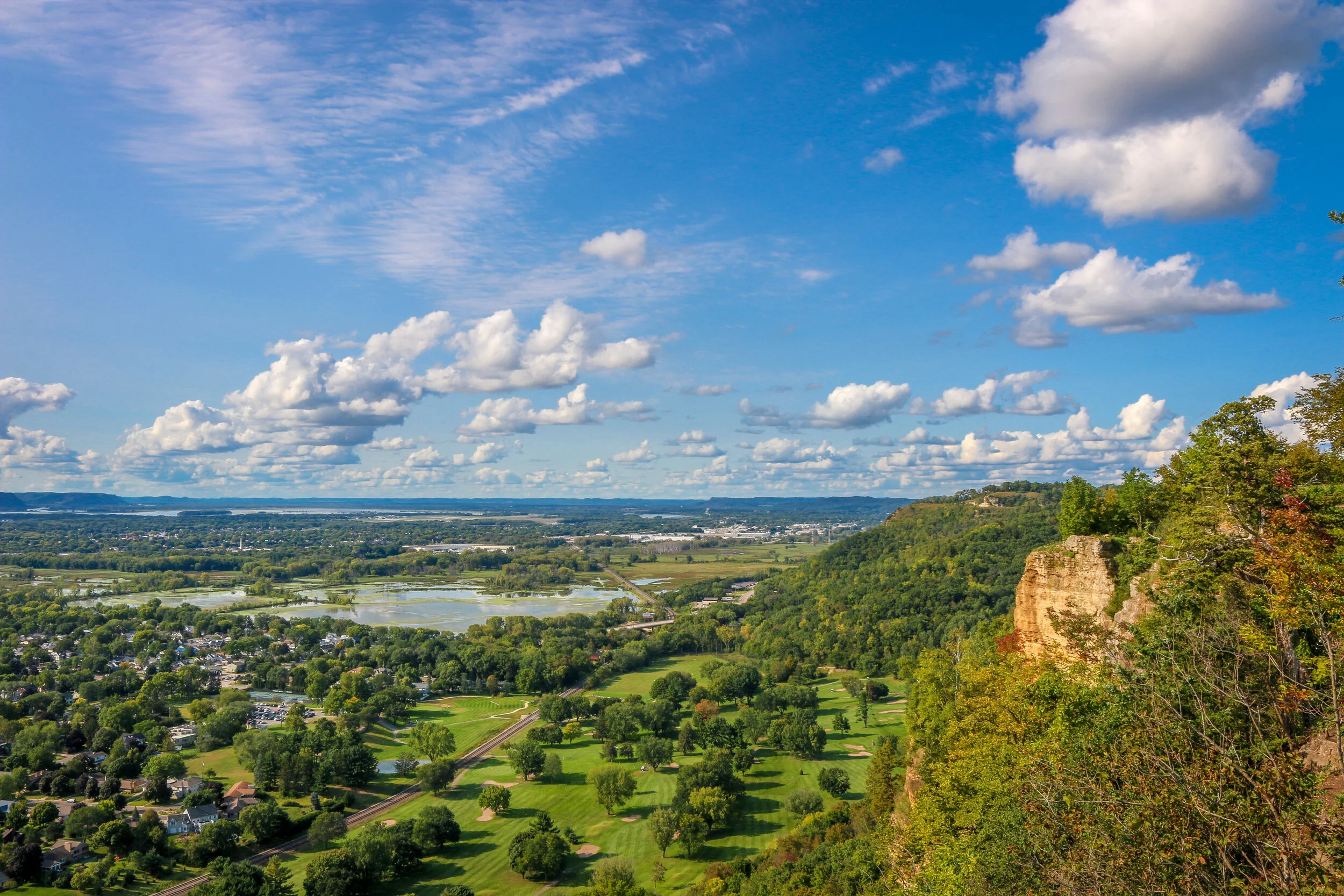
Thursday I spent a good chunk of time in the library, trying to get a jump on some work for this week. In the afternoon I drove up Grandad’s Bluff, La Crosse’s most well-known geologic feature. The road took me right to the top for wonderful views out over the city and the Mississippi River. It was cool and quiet up there and I stayed up on top for quite some time. Later that evening I went for a stroll along the Mississippi and then to a wonderful night of live music at the amphitheater right there on the river. It’s getting a little cooler out and it was nice to just sit outside and have a beer and enjoy the music. The band was good and I stayed right up until the end. Afterwards I joined my friend from the previous evening at the old train station for a really good grandfather-grandson duo and met her boyfriend and granddaughter. When the band finished up, I took one last stroll around town and then called it a night.
Friday morning I was up and off and headed north along the Great River Road. I stopped in the small and charming river towns of Trampealeau and Alma for a while and found a nice apple orchard along the way to pick up some fresh apples which are just coming into season up here. Then I headed on to Nelson for lunch under the Twin Bluffs and an ice cream at their wonderful creamery. From there, I moved on to Pepin which is best known as the birthplace of Laura Ingalls Wilder.
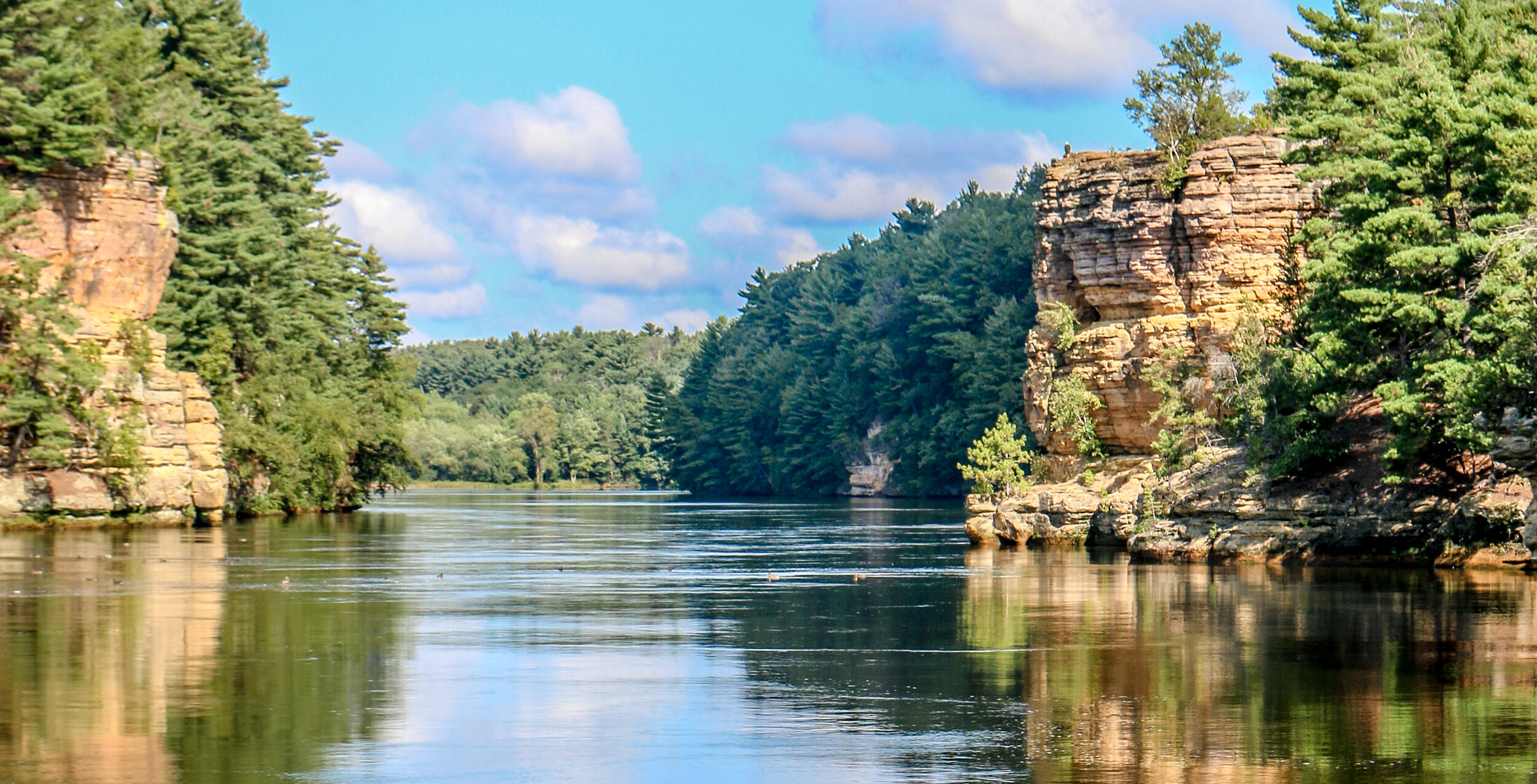
The Potsdam Sandstone that makes the beautiful formations we find in the Wisconsin Dells was formed 500 million years ago during the Cambrian Era when this area was the sandy shore of a vast inland sea. 15,000 years ago, during the last Ice Age, the glaciers came within 4 miles of The Dells but never quite got there, making this the edge of what is called The Driftless Region (the part of Wisconsin which evaded glaciation). When the Ice Age started to end, the meltwater formed a massive lake known as Glacial Lake Wisconsin. When the ice dam that held the lake back finally collapsed, it unleashed a massive flood which carved the gorges of the Wisconsin Dells in a matter of days or weeks. We get the word ‘Dells’ from the French word ‘dalles’ which means slabs of rock.
Human history in the area stretches back thousands of years, but the modern era of The Dells as a tourist draw can be traced to legendary photographer H.H. Bennett. Bennett took up photography after the Civil War but became frustrated that he could not capture moving objects on film without them blurring. He built his own camera which he referred to as a “snapper” and took a famous photo of his son jumping to Stand Rock. This photo circulated around the country and then the world and people had to come and see these Dells for themselves. The Dells became quite a mess with all of the attempts to capitalize on this beautiful natural area’s popularity (think Niagara Falls), but thankfully it has been designated a State Natural Area which is overseen by the State of Wisconsin. The weird tourist traps which have persisted are thankfully out of view of The Dells themselves.
I came to The Dells a few times when I was a kid and always remembered it as a beautiful place. I was happy to find I still thought that after many years away and having visited a lot of beautiful areas in the interim. I took the Upper Dells boat tour and a DUCK tour of the Lower Dells while I was there and enjoyed both of them (although choosing between the two would be easy - the Upper Dells all the way). I was also lucky to have absolutely beautiful weather while I was there. I hope you enjoy these photos from my visit to the beautiful Wisconsin Dells.
South Haven, Michigan is a charming little port town where the Black River flows into Lake Michigan. Originally inhabited by the Potawatomi people, the first settlers arrived in the 1850s. Like many towns along this coast, South Haven started out as a lumber town, supplying the trees to build the towns as the United States expanded westward. As the trees were cleared, farmers took advantage of the open fields to plant fruit, and the area grew to be a major supplier of fruit to the Great Lakes region and beyond. Today there is still plenty of traffic moving up and down the Black River and in and out of Lake Michigan, but South Haven has also made tourism a major industry. The beach is warm and welcoming, the downtown area is clean and lively and there is definitely plenty to keep you busy on a short or long stay. Of course, sunset is the highlight of every day along the Sunset Coast of Michigan. I was there over the 4th of July weekend and while it was probably busier than usual, South Haven maintained its small-town cool and handled the busy weekend well. I really enjoyed my stay in South Haven and hope you enjoy these photos from my visit.
After being turned back south after the Battle of Antietam, Confederate General Robert E. Lee marched his army back to Virginia. Union General George McClellan was replaced by General Ambrose Burnside to command the Army of the Potomac, and President Lincoln urged Burnside to pursue the Army of Northern Virginia deep into the state and attack the Confederate Capital at Richmond. The major obstacle lying in their way was the Rappahannock River.
Burnside arrived at Stafford Heights overlooking the river and the small town of Fredericksburg in mid-November, 1862. He had sent orders to have pontoons at the ready to provide a means of bringing his army rapidly across the river. Tragically for Burnside and his men, the pontoons didn’t arrive for several weeks. Instead of crossing the river in boats or rafts, he chose to wait for the pontoons. By the time they got there, Confederate troops had dug in on the high ground south of the city called Marye’s Heights and behind a stone wall along a sunken road to the front of this position.
Union engineers worked through the night of December 10th to assemble the pontoon bridge, but their progress was slowed by Mississippi sharpshooters in town. A small group of Union soldiers crossed the river in boats and fought a battle to secure the streets of the town. They finally secured the town in late afternoon on the 11th, but it was winter and the daylight soon gave out. The bridge would be completed and most of the army would cross it on December 12th.
In 1713, two colonists were granted a tract of land extending from what is now Cleveland Park all the way to present-day Rockville. That tract long predates both the city of Washington DC and the United States as a whole, and its owners named it “Friendship”.
By the turn of the 20th Century, only two homes were located in the area, one was located a few hundred yards back from Wisconsin Avenue in a grove of silver maples, and the other lay closer to the road and was owned by the Ball family. This home had an attached blacksmith shop and also served as a changing station for stagecoaches bound between Rockville and Georgetown. In the early 1900s, trolley tracks were laid connecting Georgetown to Montgomery County, and the area became prime real estate.
Over the next decade, the land was purchased and subdivided by two men, Albert Shoemaker and Henry Offutt, and a small community began to developed. By 1914, the Village of Friendship Heights and The Hills was recognized by the state of Maryland, and the community around it was also known as Friendship Heights. This was a rural area, and an annual fall hog slaughter was a much anticipated event…
Our National Parks are our greatest treasure here in the United States. They are magical places which thankfully our forefathers had the foresight to set aside in perpetuity for their children and our children and their children. They preserve some of our most amazing landscapes and ecosystems and protect all manner of flora and fauna. From the Everglades in Florida to Denali in Alaska, even the names call forth wildness in our imaginations. Have no doubt, these are our lands, and if we want to keep them that way, we need to protect them. But most of all, we need to enjoy them. This is the second post in a series I have titled In Focus, which will take a look deeper into our National Parks. These are primarily photography posts, trying to show you the beauty of our parks and take you inside of them with me. My hope is that you will get out and see them for yourself. After all, they belong to you too.