I absolutely love Joshua Trees. Much like the Saguaros are iconic to the Sonoran Desert, the Joshua Trees are iconic symbols of the Mojave Desert and it’s too easy to imagine human characteristics in both. Every time I pull into an area with Joshua Trees it makes me smile and feel happy. Interestingly, Joshua Trees aren’t really trees at all, but rather a tree-like member of the yucca family. They may have been given their name by early Mormon pioneers who thought they resembled the Biblical Joshua with his arms raised.
It is believed that people have been living in the region of Joshua Tree National Park for 10,000 years. The first people of European descent who laid eyes on the area were with Spaniard Pedro Fages who was pursuing Native Americans who had “escaped” the mission in San Diego. After the Mexican-American War, American settlers started moving in, building ranches and doing some small-scale mining. Franklin Roosevelt protected the area as Joshua Tree National Monument in 1936 and it became a National Park in 1994. The park covers 1,242 square miles - slightly larger than the state of Rhode Island.
I’ve visited Joshua Tree National Park several times before, but always in the middle of summer when it was boiling hot out. We might get out and take some photos, but long hikes were pretty much out of the question. I was really happy to get there this past spring when it was cool and pleasant and I could get out on the trails. I hiked the Short Loop Trail from Black Rock Campground, Ryan Mountain, and the Lost Horse Mine Loop among others and they were all fantastic. Joshua Tree National Park is a special place and while it doesn’t get the hype of our other western National Parks, it’s definitely worth a visit. I can’t wait to return. I hope you enjoy these photos from beautiful Joshua Tree National Park.
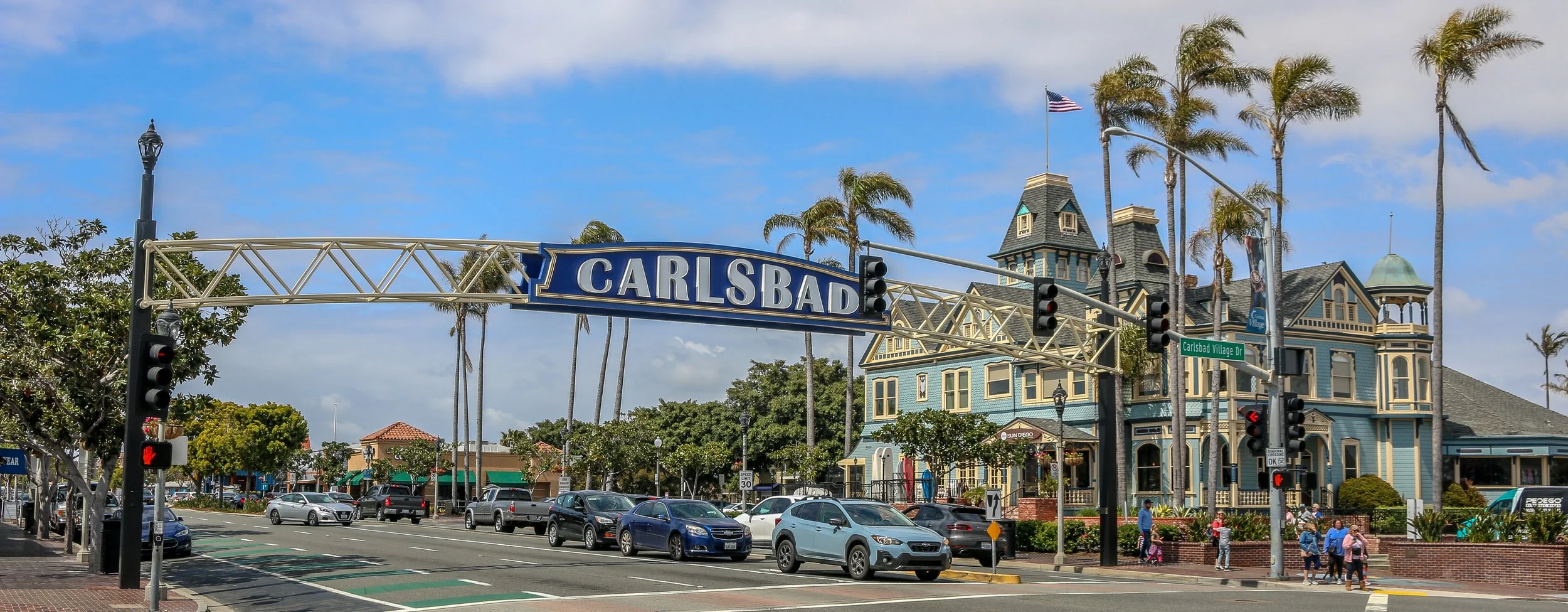
Located right on Highway 101 between Los Angeles and San Diego is the gorgeous little city of Carlsbad. As you drive down the highway, you can’t help but notice the beautiful Twin Inn on the inland side of the road. It’s the kind of building that just sparks your interest, especially a block from the beach in Southern California. The Inn was built by Civil War veteran Gerhard Schutte in 1887. Schutte and his partners laid out the townsite of Carlsbad as “a town of small farms and gracious homes”. They sold plots at $40/acre and the town grew from there.
This area was originally inhabited by the Payómkawichum and Kumeyaay people who enjoyed the bounty of the sea and the fresh water provided by Buena Vista Creek. When the Portola Expedition came to California in 1769 they camped on Buena Vista Creek and mingled and traded with the native people. During the Mexican period, the area that is now Carlsbad was part of Rancho Agua Hedionda which wasowned by Juan María Marrón.
In the early 1880s, a man named John Frazier dug a well and served up water to thirsty train passengers on their way through. It turned out that the water was quite special and the area became known as Karlsbad after a famous Bohemian spa town. Enter Gerhard Shutte and his Carlsbad Land and Mineral Water Company which laid out and promoted the town as mentioned above.
Today, Carlsbad is a pleasant, medium sized city of about 114,000 people. I really enjoyed walking around on a beautiful, sunny spring day to take these photos. The old train station has been converted into the town’s visitor center and the Twin Inn has been incorporated into the Village Faire shopping area. I also loved the many old and quirky buildings I found as I made my way around the city center and the modern parts of Carlsbad have been tastefully added to enhance the city’s beauty. There are plenty of beautiful murals around and some great shops and restaurants as well. I’m so glad I stopped in to see Southern California’s stunning Village by the Sea. I will definitely be back to visit again in the future. I hope you enjoy these photos of beautiful Carlsbad, California.
The area that is now Wickenburg was once Yavapai Indian land and the river that runs through it is the Hassayampa which means “following the water as far as it goes” in the Yavapai language. In 1863, German prospector Henry Wickenburg came to the area in search of gold. He found it and opened the Vulture Mine which would eventually produce 340,000 ounces of gold and 260,000 ounces of silver.
Ranchers came to the area as well and soon a community sprang up. In 1895, the railroad came through Wickenburg which spawned even more growth. The town was incorporated in 1909, making Wickenburg the oldest Arizona town north of Tucson and the 5th oldest in the state. In 1866, Wickenburg missed being named the territorial capital by just two votes.
Today Wickenburg is a quaint little community with a real wild west feel to it (some of the light posts are even wearing cowboy hats). There are some amazing art installations around town and the Desert Caballeros Western Museum is one of the best in the state. I love the design of the Saguaro Theatre which was also probably my favorite theatre in Arizona. You’re never alone when you’re in Wickenburg as life-like statues are spread throughout town making for a family friendly feel. I hadn’t planned on staying long in Wickenburg, but it’s a great town worth exploring and I was there way longer than I expected to be. Next time you’re in this part of Arizona, stop in for a spell. You’ll be glad you did. I hope you enjoy these photos from tiny Wickenburg - the Dude Ranch Capital of the World.
Organ Pipe Cactus National Monument was one of the top spots on my list of places to visit during my time in Arizona. It’s a remote park, located two hours from anywhere and right on the U.S./Mexican border, but it’s the only place in the country that you can find naturally occurring organ pipe cactus. In addition to these beauties, there are so many other species of cactus and desert plants as well which has led to this region also being named a part of UNESCO’s International Biosphere Reserve.
Organ Pipe Cactus was made a National Monument by Franklin Roosevelt back in 1937. A special act was passed to allow mining in the area during World War II, an act which sadly wasn’t repealed until 1976. The park’s remote location on the Mexican border used to bring both drug runners and human smugglers through the area, making this America’s most dangerous park. This danger is memorialized in the Kris Eggle Visitors Center which was named for a park ranger who was killed protecting visitors from drug smugglers in 2002. In the wake of his death, the border was reinforced and I felt safe there during my stay.
It was unbelievably hot when I arrived on an afternoon in late April. So hot that I couldn’t actually do anything but hover in the shade of the restroom and wait until the sun started to go down. I did enjoy a wonderful evening hike and an early morning one the following day as well. The area is beautiful and it was great to see the Organ Pipes in their native habitat. It was definitely just a one night stop, but I’m very glad I went. I hope you enjoy these photos from Organ Pipe Cactus National Monument.
Construction on Fort Bowie began in 1862 after two separate confrontations between the United States Army and the Chiricahua Apache. The fort was erected to protect the Apache Pass through the mountains and Apache Springs, a vital water source in the area. Six years later a more substantial fort was built just up the hill from the original fort and would be in service until 1894. The Apache Wars would end in 1886 with the surrender of Chiricahua leader, Geronimo, and the removal of the Chiricahua from the area. As you may remember from a recent post, the U.S. Army was aided in this endeavor by the White Mountain Apache scouts based in Fort Apache to the north who were the sworn enemies of the Chiricahua.
The fort today is a mere remnant of what it once was. The adobe walls have all but melted back into the surrounding desert and the stone foundations and a few odds and ends are all that is left. This park is unique in that it is a “hike-in” park, meaning the only way to visit it is by hiking the 1.5 miles from the parking lot up to Apache Pass. This walk takes you past the old stagecoach stop ruins, the cemetery, an old Apache village, Apache Spring and up to the pass where the fort is located. While the rangers at the park will provide access for people with disabilities, this walk is an amazing way to get a feel for the remoteness of the fort and the isolation the men who were once stationed there must have felt. I was definitely glad I visited in the winter months as I’m sure making this walk in the summer is quite hot and dusty. I was definitely glad I finally made it out to Fort Bowie as it’s been on my to-do list for many years now and I’m glad I finally got there. I hope you enjoy these photos from Fort Bowie National Historic Park.
There may be no more iconic plant in the United States than the stately and stoic saguaro cactus. These beautiful cacti can grow up to 40’ tall and live to be 150 years old. They won’t start growing arms until they are 75 years old and some will grow many arms in their lives. Most of the natural habitat of the saguaro is in the Sonoran Desert which straddles the U.S./Mexico border.
In 1933, President Herbert Hoover designated Saguaro National Monument which we now call the Rincon Mountain District of the park. In 1961, John F. Kennedy added the Tucson Mountain District to the Monument and in 1994 these two tracts were combined into Saguaro National Park.
Rio Grande del Norte is one of our more recent National Monuments, having been designated as such in 2013. It protects the confluence of the Red River and the Rio Grande which are both designated Wild and Scenic Rivers. Both gorges are gorgeous and the point of land above the confluence, called simply El Punto, provides amazing views from high above the two rivers. I hiked the Little Arsenic Trail while I was there, which brought me down to the Rio Grande and led me straight to the confluence. It was one of the better hikes I did during my stay in New Mexico and was very rewarding around every turn. I spent the night at the campground on the canyon rim and enjoyed a beautiful sunset in the evening and a magical sunrise the following morning. In between, the stars were spectacular. I debated whether to drive out to this park as it was somewhat out of the way, but I’m sure glad I did as it is stunning from end to end. If you’re ever in the area, you should as well. I hope you enjoy these photos from beautiful Rio Grande del Norte National Monument.
Nara Visa, New Mexico got its start as a rail town when the Chicago, Rock Island and Pacific Railroad was being built around the turn of the 20th century. It was originally called Narvaez after a local family who had farmed in the area for decades, but was eventually anglicized to some degree to Nara Visa. Within a decade, the town had grown to include 4 churches, 8 saloons, a couple of hotels and a whole array of small businesses. In 1921, with a growing population of 651, a fine school was built and the Works Progress Administration helped add a gymnasium a decade and a half later. The depression took its toll on the town though and lean years were ahead for Nara Visa. By 1968, there were only 7 students enrolled at the school when it closed its doors for the last time. Today less than a hundred people call the town home, and none of the businesses from this once thriving little community are open. It’s easy to pass through Nara Visa and not see it at all. I’m glad I got out and had a look. It makes me sad when towns die, but the reality is that everyone leaves at some point, one way or another. It looks like times were good there once, and maybe will be again at some point in the future. It sure made for some nice photos though. I hope you enjoy these photos from Nara Visa - a modern day ghost town in eastern New Mexico.
Construction of the pueblo at Pecos was begun sometime in the 12th century. Over the next few hundred years it would grow to become one of the largest pueblos in the area, supporting a community of perhaps 3,000 people. Sitting in what is now eastern New Mexico, this agricultural community was also a trade center between the mountains to the west and the plains to the east. Francisco Vázquez de Coronado visited Pecos on his 1540 conquest, as did Don Juan de Oñate 60 years later when he ordered construction of a mission church to help convert the Puebloans to Catholicism. That church was destroyed during the Pueblo Revolt of 1680 and a smaller church would be built in its place when the Spanish returned to the area twelve years later. The spread of European diseases would bring the ultimate demise of Pecos and in the 1830s the last of its old residents made their way to Jemez Pueblo where their culture and tradition is still remembered in the oral history. Emigrants on the nearby Santa Fe Trail no doubt used Pecos as a campground and marveled at the old pueblo. General Kearny and his troops camped at Pecos as well on their westward journey to claim New Mexico for the United States. During the Civil War, the Confederate army was making their way through New Mexico on a quest for Colorado and California gold. Their troops turned back to Texas after being defeated at the Battle of Glorieta Pass which is right up the trail from Pecos. Tex Austin purchased the land in 1925 and turned it into the Forked Lightning Ranch which was purchased in 1941 by Buddy Fogelson. The Fogelsons were instrumental in creating Pecos National Monument in 1965, and after their deaths the park’s boundaries were expanded to include the ranch and the designation changed to Pecos National Historical Park.
Today the park does an incredible job of interpreting all of this fascinating history in its wonderful museum. The 1.5 mile trail takes you through the remains of the pueblo and into the ruins of the old mission church. Two kivas have been reconstructed to provide some insight into Puebloan culture and religion as well. It’s a beautiful place to visit and just a short drive from nearby Santa Fe. I hope you enjoy these few photos from fascinating Pecos national Historical Park.
“The Original Las Vegas” was founded along the Galinas River in 1835 in the midst of Mexican rule in the area and quickly grew as a popular stop on the Santa Fe Trail. It was on the Plaza in Las Vegas where Stephen Watts Kearny claimed New Mexico for the United States during the Mexican-American War in 1846. In 1879, the Atchison, Topeka and Santa Fe Railroad came to Las Vegas and the town quickly grew into one of the largest in the region. The New Mexico Normal School (now Highlands University) was established in 1893 and Fred Harvey built the Castañeda Hotel in 1898 as part of his hospitality empire in the southwest. Las Vegas hosted Teddy Roosevelt’s Rough Riders’ first reunion in 1899, a tradition that continued for many years. In more recent years, Las Vegas has been the filming location for many movies including No Country For Old Men, Wyatt Earp (with Kevin Costner), and perhaps most notably for me, Red Dawn where it served as the fictional town of Calamut (the massive “Calamut Says Howdy” mural is still a prominent feature downtown). I found Las Vegas to be a quiet, charming University town with some spectacular architecture, fascinating history and friendly people. It may be the “other Las Vegas”, but it’s a town not to be missed on your travels in New Mexico. I hope you enjoy these photos from wonderful Las Vegas, New Mexico.
In 1598, Juan de Oñate y Salazar was on a conquest to colonize Nuevo Mexico for Spain. Traveling north of El Camino Real, his caravan had just passed through the dreaded 90 mile stretch known as the Journada del Muerto or “Journey of the Dead Man” when they encountered the Piro people of the Tempana Pueblo. These people offered the party food and water and Oñate called the place “Socorro” meaning succor or aid. In 1626, the Spanish built a mission church nearby and christened it Nuestra Señora del Perpetuo Socorro or Our Lady of Perpetual Succor. The mission was abandoned and destroyed during the Pueblo Revolt of 1680 and wouldn’t be resettled until 1815. A beautiful new church was built and named after San Miguel.
I came to Socorro because it was where I was when I ran out of steam for the day. It was on my radar, but I didn’t know if I would have time to stop. I’m sure glad I did. There are so many wonderful historic buildings around town, and the evening was absolutely perfect for photography. I enjoyed a nice long walk around downtown and then settled into the mining-era Capitol Bar for a couple of their house-brewed beers. Then I ventured out to El Camino Restaurant and Lounge, a holdover from another time. Both the restaurant and the lounge are worth visiting for the ambiance alone. It snowed overnight and while there wasn’t much on the ground, the mountains had a lovely dusting. I happily snapped a few more shots with the snow before hitting the road. Socorro is definitely worth a stop on your way through New Mexico and I hope you enjoy these photos from my brief time in this wonderful little town.
People have been visiting the natural hot springs in the Palomas Basin for centuries. The Spanish called them Ojo Caliente de Las Palomas and the cowboys called them Palomas Hot Springs. In the late 18th century, a public bath was built on a ranch in the area where people could come and take the waters. When the Elephant Butte Dam was built in 1912 to help with irrigation, the area became more attractive to settlers and the town of Hot Springs, New Mexico was incorporated in 1916. Twenty-one years later, it would become the county seat of Sierra County. In 1950, Ralph Edwards, the host of the popular radio show Truth or Consequences, promised to air their 10th anniversary show live from any town that would change its name to match that of the show. Hot Springs residents jumped at the opportunity and officially changed its name to Truth or Consequences. Edwards made good on his promise and visited the town on the first weekend of May every year for the next 50 years. His visit was turned into a celebration, Fiesta, which still happens every year at that time. T or C, as the locals call it, is a wonderful and colorful little town full of hot springs resorts and art galleries and with a backdrop of beautiful mountains that light up when the sun is low in the sky. I loved my brief stay in one of the country’s most uniquely named towns, and I hope you enjoy these photos of fabulous Truth or Consequences.