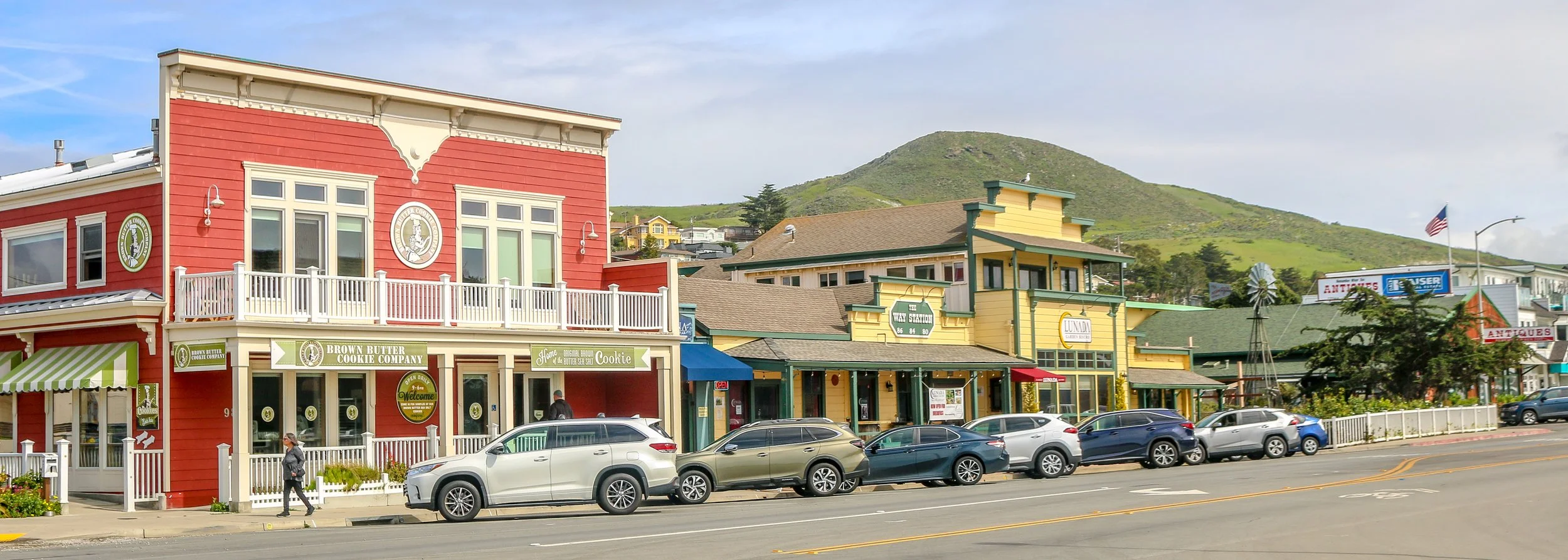
Cayucos is a pleasant beach community located on the Estero Bay along the Central California Coast. Originally inhabited by the Chumash people, the area was explored by the Portola Expedition in 1769. The Spanish explorers noted the Chumash out fishing in small canoes and named the area Cayucos - the Spanish name for a small boat. The town was established in 1867 by Captain James Cass who built the original pier and a warehouse to store goods and make Cayucos a port town. Today Cayucos is home to around 2500 people and is a great town to stop in on your journey up or down the coast.
I stumbled into Cayucos by accident as I made my way down the Pacific Coast Highway. I stopped near the pier to use the bathroom and was impressed by the Dale Evers’ statue called The Great Communicators at the head of the pier (pictured below). I decided to stroll down the pier and enjoyed watching the surfers catch some waves. As I walked back towards my van, I saw a cool old convertible make the turn in front of me and looked down the street to see the Brown Butter Baking Company. Of course I had to stop for a cookie for research purposes, and I started to see all kinds of cool buildings to photograph. I ended up staying in Cayucos for a few hours and really enjoyed the town. It had all the amenities of any beach town along the coast, but was wonderfully clean, quiet and friendly. It’s a town I will definitely be back to and I see where they get their nickname: A Little Slice of Paradise. I hope you enjoy these photos from beautiful Cayucos, California.
The homes we now refer to as the Gila Cliff Dwellings were built beginning around 1276. The rivers in the area provided a constant source of water, a necessity in the desert and probably the reason the people who built these dwellings chose this location. While they were contemporaries of the people we now call the Ancestral Puebloans, differences in their construction styles, pottery and art have caused archaeologists to give them a different name and we refer to them as the Mogollon. The time that the Mogollon spent in these dwellings, approximately 25 years, coincides with prolonged drought in the area which caused many groups to move in search of water. It seems that the Mogollon moved into these alcoves near the beginning of the drought, and left as it was ending. When looking at history, it’s easy to think of 25 years as the blink of an eye, but it’s a whole generation of children growing to adulthood and having their own babies and adults moving into the roles of elders as elders pass on. There was love and loss and laughter as this group passed the time farming, hunting, building, creating and growing.
The Mogollon seem to have moved on around 1300 as the drought was coming to its end and these isolated dwellings likely remained empty for quite some time. The Chiricahua Apache migrated to the region in the 1500s and the great leader Geronimo was born near the headwaters of the Gila River around 1820. Spanish settlers came to the area in 1598, but there is no evidence they penetrated the wilderness anywhere near to the dwellings. Prospector H.B. Ailman documented the cliff dwellings in 1878 and by the time archaeologist Adolph Bandelier arrived in 1884, looters had ransacked the alcoves and made off with whatever artifacts were to be found. Homesteaders, miners, prospectors and ranchers arrived over the next few decades and President Theodore Roosevelt protected the area as Gila Cliff Dwellings National Monument in 1907. Not too long after he did, Aldo Leopold came to the region as a forester and lobbied the Forest Service to establish the GIla Wilderness, the first designated wilderness area in the country and an inspiration for the 1964 Wilderness Act.
Today, the Gila Wilderness is a quiet and magical place. It’s a two hour drive from Silver City, the nearest town of any real size, to the Cliff Dwellings. The road that brings you in is the aptly named Trail of the Mountain Spirits National Scenic Byway and it is a truly beautiful drive. During my visit, I toured the cliff dwellings, scouted out some beautiful pictographs, hiked the fabulous Little Bear Creek Canyon trail to the Middle Fork of the Gila River and soaked in wonderful hot springs. I loved my time in the Gila Wilderness and hope you enjoy these photos from my visit.
New Ulm is a mid-sized city which sits at the confluence of the Minnesota and Cottonwood Rivers in southern Minnesota. Founded by German-Americans, the town gets its name from the German city of Ulm in Bavaria. While not as over-the-top as Frankenmuth in Michigan, New Ulm has many German features to it and the longer you stick around the more you will see. I really enjoyed the Glockenspiel and the Hermann Monument and found several of the churches in town to be truly spectacular. The Historic Society Museum is housed in the eye-catching old post office, and even the fire hydrants brought a smile to my face. On the outskirts of town is the old A. Schell Brewery, which is definitely worth a stop. Founded in 1860, it’s Minnesota’s oldest brewery and one of the oldest in the country. Unlike most of the town, it was spared during the Dakota War of 1862 which devastated New Ulm. I had a wonderful German meal at the Ulmer Cafe and talked to some welcoming locals while I was in town. I hope you enjoy these photos from beautiful New Ulm, Minnesota’s Most German City.
Michigan became a state in 1837 with its Capital City in Detroit. At some point in the 1840s, a debate grew over the vulnerability of Detroit which sits right across the lake from Canada and had been occupied in the War of 1812. Many cities vied for the seat of government, and the compromise was to build a new Capital City at a strategic inland crossroads. The area, known as Lansing, was renamed Michigan City, but the original name would be restored the following year. A two story wooden structure with a tin roof was built to house the state legislature and would serve as the State Capitol for for over 20 years. Finally, in the 1870s, construction on the current Capitol was begun. Elijah Meyers was chosen as the architect and he modeled the building after the U.S. Capitol in Washington. Meyers would go on to design the Colorado and Texas Capitols as well. The building opened in 1879. A hundred years later, people were calling to pull down the old building and replace it with a modern structure like they tragically did in Louisiana, Florida and elsewhere. Thankfully, that did not happen and instead a major, top-to-bottom restoration took place. The meticulous restoration even brought in artists to hand-paint all of the walls as had been done in the original design. The result is really quite something. The Michigan State Capitol is beautiful inside and out, and I was very fortunate to get a personal tour with the building’s lead guide. I hope you enjoy this look inside the beautiful Michigan State Capitol in Lansing.
Frankenmuth, Michigan is a whimsical fantasyland of Bavarian architecture, fried chicken, cheese and chocolate. The town was originally settled in 1845 by German immigrants from Franconia who combined their homeland’s name with the word “muth” for “courage” and called their new home Frankenmuth. These early settlers were Lutherans and attempted to convert the local Native Americans to their religion without much success. They did build one of the larger Lutheran churches in the state though. Today, people come from far and wide to eat chicken at either Zehnder’s or the Bavarian Inn, right across the street. I chose the Bavarian Inn and the chicken was good, but not great. I did enjoy the feel of the town, the architecture and strolling around the shops and down by the river. It’s definitely different and very photogenic. I hope you enjoy these photos from tiny Frankenmuth, Michigan.
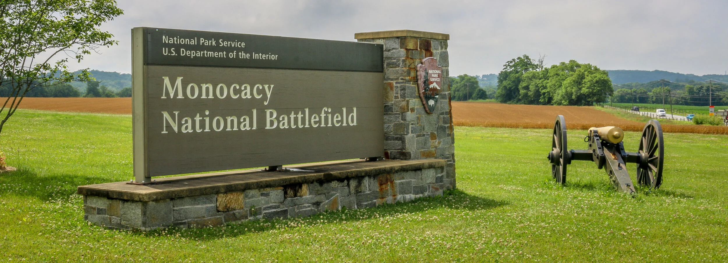
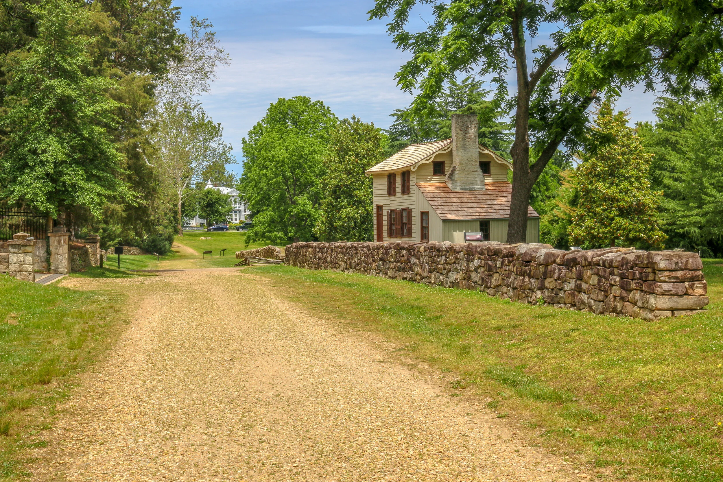
The photos below come from a recent visit to Monocacy National Battlefield Park just south of Frederick Maryland - site of the “Battle that Saved Washington”. Civil War Chronicles will trace the major battles of the Eastern Theater of the war through photos and brief histories.
The Battle of Monocacy is a bit of an outlier in that it wasn’t really a major battle of the Eastern Theater of the Civil War, but a minor one with major implications. While Generals Grant and Lee were engaged in the final grappling of the war around Petersburg, south of Richmond, Lee wanted a distraction to pull some of Grant’s army away. He attempted this by sending General Jubal Early to go on the offensive and attack into Union territory, the third Confederate invasion of the North during the war. Early was sent with 15,000 men to threaten Washington D.C. and, if possible, to raid the prison camp at Point Lookout and free the Confederate soldiers being held there. Lee also knew that a presidential election was looming and he hoped that another invasion of the North might bring about the defeat of Lincoln and a favorable end to the long and brutal war.
Early’s army crossed the Potomac River into Maryland on the 4th of July, 1864 and marched past Sharpsburg, the site of the Battle of Antietam two years earlier. You can’t march 15,000 infantry troops across a state without anyone noticing, and word quickly got to General Lew Wallace who was then the Union commander in Baltimore. Wallace gathered what men he could muster and quickly set off towards the west. Thinking quickly, Wallace decided to head towards Monocacy Junction, just south of Frederick, Maryland. He didn’t know where the Confederates were headed, but this point would allow his troops to defend the Georgetown Pike to Washington, the National Road to Baltimore and the Baltimore and Ohio Rail Line. If he got there first, he could strategically place his men along the Monocacy River and defend all three of those routes which crossed the river at that point. He arrived in time to dig in and establish a line of defense.
After being turned back south after the Battle of Antietam, Confederate General Robert E. Lee marched his army back to Virginia. Union General George McClellan was replaced by General Ambrose Burnside to command the Army of the Potomac, and President Lincoln urged Burnside to pursue the Army of Northern Virginia deep into the state and attack the Confederate Capital at Richmond. The major obstacle lying in their way was the Rappahannock River.
Burnside arrived at Stafford Heights overlooking the river and the small town of Fredericksburg in mid-November, 1862. He had sent orders to have pontoons at the ready to provide a means of bringing his army rapidly across the river. Tragically for Burnside and his men, the pontoons didn’t arrive for several weeks. Instead of crossing the river in boats or rafts, he chose to wait for the pontoons. By the time they got there, Confederate troops had dug in on the high ground south of the city called Marye’s Heights and behind a stone wall along a sunken road to the front of this position.
Union engineers worked through the night of December 10th to assemble the pontoon bridge, but their progress was slowed by Mississippi sharpshooters in town. A small group of Union soldiers crossed the river in boats and fought a battle to secure the streets of the town. They finally secured the town in late afternoon on the 11th, but it was winter and the daylight soon gave out. The bridge would be completed and most of the army would cross it on December 12th.
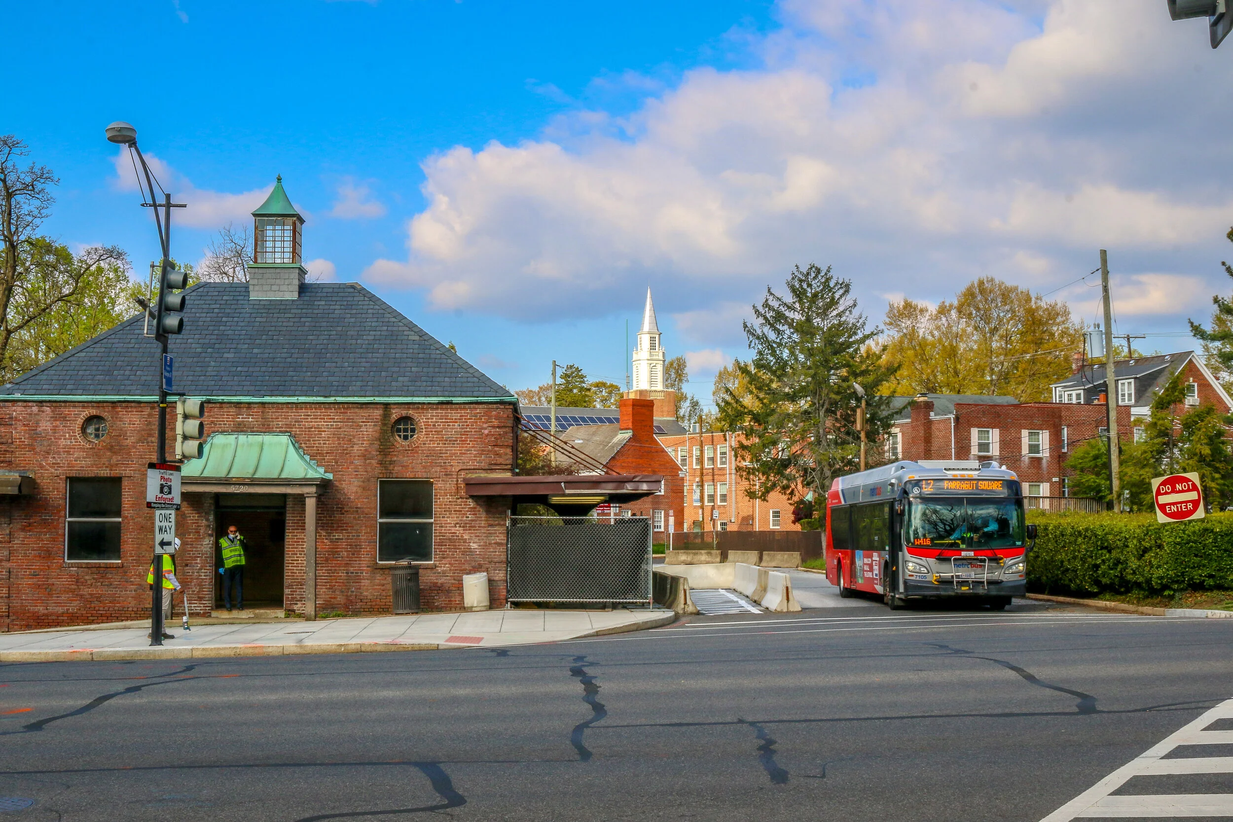
Chevy Chase dates back all the way to 1725, when Col. Joseph Belt was granted 1000 acres by Lord Baltimore, the first proprietor of the Colony of Maryland. Col. Belt, who had commanded the Prince George’s County Militia in the French and Indian War, named his new farm Cheivy Chase after an area in Northern England. A portion of the land was bought up for development in the late 1800s, and lots began to sell when a streetcar line connected the neighborhood to downtown Washington. Many of the houses in Chevy Chase were bought straight from a Sears and Roebuck catalog and remain standing today. Much of the architecture in the area is in the humble Bungalow, Foursquare and Dutch Colonial styles, but many of my favorites are in the less well represented Tudor revival style. Some of the key landmarks of the community are Magruder’s Market which opened in 1875, the 1923 Avalon Theater and the far newer Chevy Chase Library and Community Center. Chevy Chase is my home neighborhood, and I have wonderful memories from my childhood of movies at the Avalon, art and gymnastics classes at the community center, going to the old Riggs Bank with my grandmother and for ice cream at the long-gone Baskin Robbins. I often take my morning walk up Connecticut Avenue, the central road of the neighborhood, and reminisce about times gone by and five generations of my family who have wandered these streets. It made my heart feel good to go out and shoot these photos of my home neighborhood.
What exactly is Galveston? Is it a typically Southern town? An island with a beach vibe? An historic port city like New Orleans? A Texan town? The answer to all of those is “yes”. Galveston is a fascinating place with so much to offer. Even after a few days there I felt like I had only begun to scratch the surface of the Queen City of the Gulf.
The first non-natives to inhabit Galveston came in 1816 with the pirate Louis-Michel Aury. When Aury went on a raid the following year, he returned to find that the island had been occupied by the infamous pirate Jean Lafitte. Lafitte set up a “Pirate Kingdom” there and remained with his people for the next 5 years. The Port of Galveston was established under the Mexican government in 1825, and the town would serve briefly as the capital of the Independent Republic of Texas in 1836. Galveston, along with the rest of Texas, joined the Confederacy during the Civil War and became a target due to its major port…
On August 25th, 1699, Jean Baptiste LeMoyne, the Sieur d’Bienville was exploring the region that is now Mississippi’s Gulf Coast under a French flag and named this bay for King Louis IX. A small settlement was begun, consisting of just 16 soldiers. After the area was bought from France as part of the Louisiana Purchase of 1803, it was opened to homesteaders and thousands of people poured in from the Upper South. The town, originally called Shieldsboro, was incorporated by the first Mississippi state legislature in 1818 and it wouldn’t be until 1875 that its original name was restored. Bay St. Louis was severely damaged by Hurricane Katrina in 2005, and is still in the process of recovering from the storm. Today, Bay St. Louis is a charming little town of about 10,000 people. The downtown area is bustling with restaurants, bars and quaint local shops and the beach is a lovely place to while away an afternoon. Located just an hour from New Orleans, Bay St. Louis shares many of the Creole characteristics of The Big Easy. I loved my visit to Bay St. Louis, and found it to be one of the most livable places on the Gulf Coast of Mississippi. But don’t tell anyone that. It’ll just be our little secret. I hope you enjoy these photos from Bay St. Louis, A Place Apart on Mississippi’s Gulf Coast.
Columbus charmed me from the minute I arrived. It is a lovely, small city of about 25,000 located in eastern Mississippi on the Tombigbee River. Columbus, called The Friendly City, is the county seat of Lowndes County, and boasts one of the most beautiful county courthouses in the state. It forms one point of the “Golden Triangle” with nearby Starkville and West Point. Founded in 1819, Columbus has some wonderful historic homes, churches and businesses, and won the Great American Main Street Award in 2010. The town briefly served as the Mississippi State Capitol in 1863 when Union forces occupied Jackson. Nearby Columbus Air Force Base is the main driver of the city’s economy, but Columbus is also home to the Mississippi University for Women (called “The W” locally). Playwright Tennessee Williams was born in Columbus, and his birthplace now serves as both a hometown tribute to Williams, and the town’s Welcome Center. Catfish Alley, the city’s old African-American Business District was once a thriving community in which some of Mississippi’s great blues musicians played. Bukka White even wrote a song about the area in 1969 called Columbus Mississippi Blues.. Friendship Cemetery is one of several places in the country which claims the origin of our Memorial Day and has some beautiful and moving monuments and memorials.
Today, you’ll find a quiet and friendly city with some wonderful restaurants, beautiful antebellum homes and a classically Southern, Mississippian and American downtown. Highlights for me were definitely the Stephen D. Lee Home, the Tennessee Williams Birthplace, the cemetery, a stand-alone barber’s pole and just wandering the historic district and seeing the beautiful homes to be found there. I found Columbus to be welcoming and beautiful and really enjoyed my visit. My camera was also very busy during my stay, and I hope you enjoy these photos from my time in The Friendly City of the Black Prairies.
West Point, Mississippi is a pleasant, medium sized town in Clay County in the east-central part of the state. Perhaps best known as the hometown of legendary bluesman Chester “Howlin’ Wolf” Burnett, I found it to be a wonderful place to spend an afternoon. There are some beautiful old buildings, some delightful parks and some wonderful murals and artwork, all packed into a compact and walkable downtown area. Originally home to Choctaw and Chickasaw Indians, the French, Spanish and British also vied for control of the region. The town itself was originally laid out as a railroad town when the Mobile and Ohio Line came through in 1858. It would grow as part of the state’s Black Belt as cotton production became Alabama’s main industry. While I couldn’t find the origin of the name West Point (interesting to me because it’s in the east of the state), Clay County was named for the Great Compromiser, Kentucky’s Henry Clay. Because of the railroad, West Point was a strategic target during the Civil War, although the only real skirmish was a small one and occurred in 1864. November 2nd, 1909 was an exciting day in town when President William Howard Taft’s train pulled into the station and he addressed the townspeople from his rail car before heading on to Columbus.
When I visited West Point, I sadly found the Howlin’ Wolf Museum closed. While I waited for a call back from the man who runs it, I grabbed my camera and went for a wander. While I was there, the clouds cleared and I found a wonderful, clean, well-kept downtown with a distinctly small-town feel to it. I loved the City Hall building, City Park, the town’s stoic churches, the old Ritz Theater, some beautiful art projects scattered around town and some really cute small businesses on Main and Commerce Streets. While I never did get into the museum (they’re building a new one in a vacant storefront on Commerce Street), I’m still glad I stopped. There wasn’t much going on when I was there, and I was okay with that. A beautiful town on a sunny day is always something to write home about. Thanks for a wonderful visit, West Point; I hope to be back when the new museum is open for business.