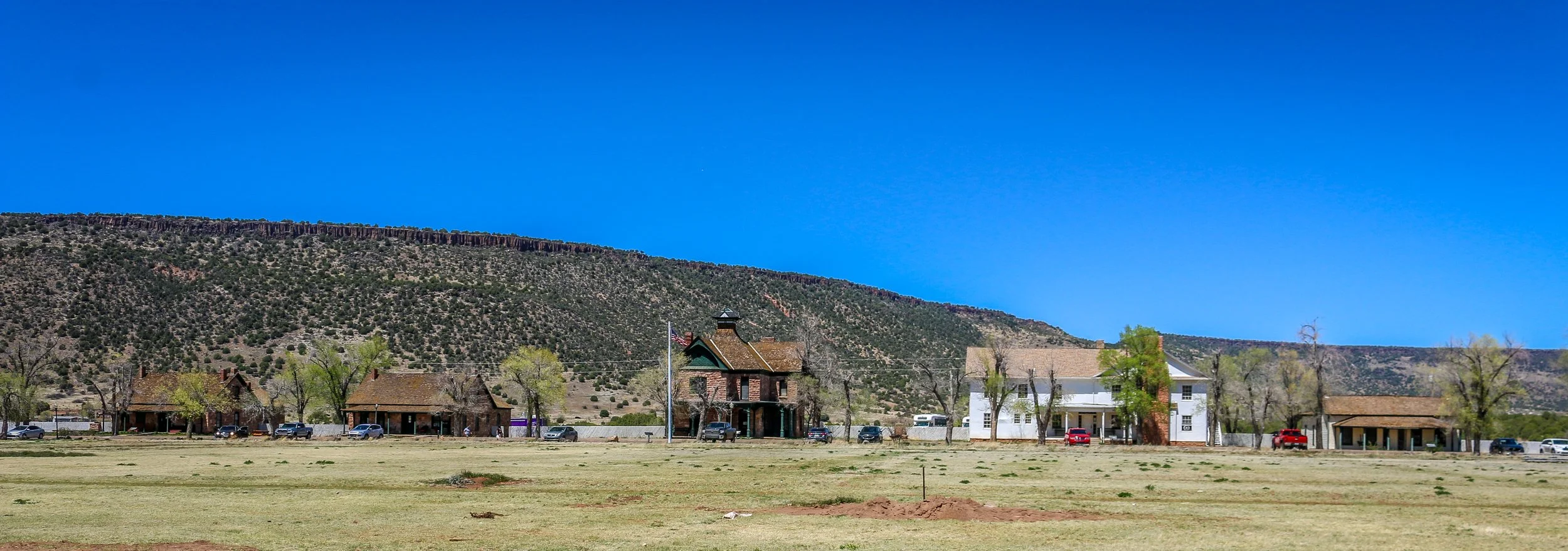
Fort Apache was constructed between 1874 and 1932 and served as an important military outpost during the Apache Wars. It rests in the midst of the beautiful White Mountains of Eastern Arizona. and is well situated at the convergence of the North and East Forks of the White River. The area is the ancestral home of the Cibicue and White Mountain Apache tribes who welcomed the United States Army to build the fort there, as they had a common enemy in the Chiricahua Apache. The White Mountain Apache are very proud of their service as scouts in the U.S. Army, and the role they played in the defeat of the Chiricahua and the capture of the great Chiricahuan leader, Geronimo. I learned a lot about the Apache Scouts and their campaigns at the wonderful "Nohwike' Bagowa" (House of Our Footprints), more commonly referred to as the Apache Cultural Center & Museum. which should be everyone’s first stop on any visit to Fort Apache.
After visiting the museum, I set off to explore the rest of the fort on a self guided walking tour which took in all of the wonderful historic buildings which remain on the post. After Geronimo’s capture in 1886, the fort remained an active military post for many years, finally closing in 1924 (although several Apache scouts remained in the army until 1947). After the army pulled out, the Theodore Roosevelt Indian Boarding School was established and the land was transferred to the Bureau of Indian Affairs as part of the White Mountain Apache Reservation. The school is still there and functioning today. I had a great visit with the kind and welcoming people of the White Mountain Apache band and really enjoyed my visit to this fascinating historic fort. I hope you enjoy these photos from Fort Apache.
Sleeping Bear Dunes National Lakeshore was designated by Congress in 1970 to protect the wonderful dunes and historic towns on the Lake Michigan shoreline between the towns of Frankfort and Glen Arbor. This region of Michigan is an absolutely beautiful stretch, with remarkable landscapes perched high over the magnificent lake. The park gets its name from an old Ashininaabek Indian story about a mother bear and her two cubs who were starving in Wisconsin and set out to swim across Lake Michigan. The way was long and the two cubs couldn’t make it. They went under and returned to the surface as the Manitou Islands. The mother bear barely made it and climbed up the dunes and turned into a dune herself, forever perched on high looking out at her two lost cubs. The scenic drive will take you to some of the best lookouts in the park including a view of the Sleeping Bear Dune, while two campgrounds allow for wonderful overnight adventures. The old town of Glen Haven tells the story of logging and industry in the area as well as early tourism. The park also covers North and South Manitou Islands, two beautiful islands an hour offshore. I had the pleasure of spending two nights on South Manitou Island and it was one of the top highlights of my whole two month visit to Michigan. The island is basically uninhabited save for a few rangers and a small handful of others, but toads, chipmunks and snakes abound. You can even find a grove of ancient cedar trees in the interior of the island. With the deepest natural harbor between Chicago and Buffalo on the Great Lakes though, South Manitou Island was once a busy place, and some of the old buildings around the island are very well maintained. I loved the old homesteads, the cemeteries and, of course, the lighthouse. In 1970, the ship Francisco Morazon ran aground off of the south shore of the island and while the crew was saved the boat still rests were it hit and is visible above the waterline. While the island is designated wilderness and camping is the only overnight option, you can visit the islands as day trips as well and tours are offered. I had a wonderful stay in Sleeping Bear Dunes National Lakeshore and highly recommend it if you are in this part of Michigan. I hope you enjoy these photos from my visit to Sleeping Bear Dunes and South Manitou Island.
What exactly is Galveston? Is it a typically Southern town? An island with a beach vibe? An historic port city like New Orleans? A Texan town? The answer to all of those is “yes”. Galveston is a fascinating place with so much to offer. Even after a few days there I felt like I had only begun to scratch the surface of the Queen City of the Gulf.
The first non-natives to inhabit Galveston came in 1816 with the pirate Louis-Michel Aury. When Aury went on a raid the following year, he returned to find that the island had been occupied by the infamous pirate Jean Lafitte. Lafitte set up a “Pirate Kingdom” there and remained with his people for the next 5 years. The Port of Galveston was established under the Mexican government in 1825, and the town would serve briefly as the capital of the Independent Republic of Texas in 1836. Galveston, along with the rest of Texas, joined the Confederacy during the Civil War and became a target due to its major port…
Ocean Springs, Mississippi got its start as a French colonial fort called Fort Maurepas way back in 1699. The fort was founded by the famed Canadian explorer Pierre Le Moyne d'Iberville and was used to protect French interests in the area from Spanish encroachment. The city was incorporated in 1892 as Ocean Springs, named after the natural springs found in the area. Today, Ocean Springs is an enchanting coastal town with a thriving artists community. There is a lovely beach with a pier jutting out into the gulf for fishing or just relaxing with a good book. Downtown if bustling with shops, galleries, restaurants and bars and is a nice break from the nearby casino-centered towns. I really enjoyed my visit to this quaint seaside community shaded by ancient oak trees draped in Spanish moss. It was cool to see the Mardi Gras decorations up while I was there and I even got to see the town’s Mardi Gras parade during my visit. If you ever find yourself cruising the Mississippi Gulf Coast, be sure you take a minute to stop into Ocean Springs for a look. You might just find yourself sticking around longer than you had planned. I sure did. I hope you enjoy these photos from Mississippi’s City of Discovery.
Founded by French colonists in 1729, Port Gibson is one of the oldest towns in what’s now the state of Mississippi. Today, it serves as the county seat of Claiborne County and it is home to the beautiful county courthouse pictured below. Port Gibson was the site of several skirmishes during the Civil War, but most of its antebellum buildings survived because General Ulysses S. Grant called the town “too beautiful to burn”. The town’s population today is probably only around 1500 which explains why it’s so quiet. There are several beautiful old churches along the appropriately named Church Street and some great old buildings around the downtown area. I really enjoyed the wonderful, sunny afternoon I spent taking these photos in the charming town of Port Gibson.
If you know me, you know how much I love the Mississippi Delta. There is just something special in the air out there. The people, the music and the food are all incredible, and the landscapes and buildings captured my heart long ago. I know that it’s an incredibly impoverished region, and that part of what makes it beautiful is the decay that goes along with this poverty. I also know that this decay is part of what brings out tens of thousands of tourists every year and they make their ways down the Blues Trail, Country Music Trail and Freedom Trail, in search of real an authentic Delta experience. Making that work is a challenging balancing act. Places like The Shack Up Inn in Clarksdale and Tallahatchie Flats in Greenwood do a remarkable job of finding that balance. Many of these photos are from those two places. Some of these photos are dated - Po’Monkey’s doesn’t look anything like it does in these photos anymore after the passing of its proprietor Willie Seaberry, but the way it used to look is how I’ll always remember it. You’ll find that dusk is definitely my favorite time to be out taking photos in the area. I’ve been coming to the Delta for over a decade now, and I’ve seen a lot of changes - many for the better, some for the worse. Either way, it’s a place that keeps pulling me back, and every time I’m there I find some new treasure. I hope you enjoy these photos which represent some of the highlights of 10 years of traveling the region. They are my favorites.
West Point, Mississippi is a pleasant, medium sized town in Clay County in the east-central part of the state. Perhaps best known as the hometown of legendary bluesman Chester “Howlin’ Wolf” Burnett, I found it to be a wonderful place to spend an afternoon. There are some beautiful old buildings, some delightful parks and some wonderful murals and artwork, all packed into a compact and walkable downtown area. Originally home to Choctaw and Chickasaw Indians, the French, Spanish and British also vied for control of the region. The town itself was originally laid out as a railroad town when the Mobile and Ohio Line came through in 1858. It would grow as part of the state’s Black Belt as cotton production became Alabama’s main industry. While I couldn’t find the origin of the name West Point (interesting to me because it’s in the east of the state), Clay County was named for the Great Compromiser, Kentucky’s Henry Clay. Because of the railroad, West Point was a strategic target during the Civil War, although the only real skirmish was a small one and occurred in 1864. November 2nd, 1909 was an exciting day in town when President William Howard Taft’s train pulled into the station and he addressed the townspeople from his rail car before heading on to Columbus.
When I visited West Point, I sadly found the Howlin’ Wolf Museum closed. While I waited for a call back from the man who runs it, I grabbed my camera and went for a wander. While I was there, the clouds cleared and I found a wonderful, clean, well-kept downtown with a distinctly small-town feel to it. I loved the City Hall building, City Park, the town’s stoic churches, the old Ritz Theater, some beautiful art projects scattered around town and some really cute small businesses on Main and Commerce Streets. While I never did get into the museum (they’re building a new one in a vacant storefront on Commerce Street), I’m still glad I stopped. There wasn’t much going on when I was there, and I was okay with that. A beautiful town on a sunny day is always something to write home about. Thanks for a wonderful visit, West Point; I hope to be back when the new museum is open for business.
Kauai was the island I spent the least amount of time on during my month in Hawaii, having only been there for a scant 48 hours. I was still very happy I made it to this distant and quiet island, as any time on Kauai is better than no time there at all. Arriving in tiny Lihue Airport, we seemed to be a world away from the sparkle and noise of Honolulu. With a population of just 72,000 people, about the same as tiny Lake Charles, Louisiana, Kauai sure does pack a punch. With lovely beaches, a rugged north coast and incredible Waimea Canyon, the Grand Canyon of the Pacific, tucked into its interior, anywhere you look you’re bound to see something beautiful. The towns are all small and quaint, the beaches almost deserted, and there was hardly a car on the road. We even made it to a luau on the beach. I hope you enjoy these photos from the lovely “Garden Island” as much as I enjoyed taking them.