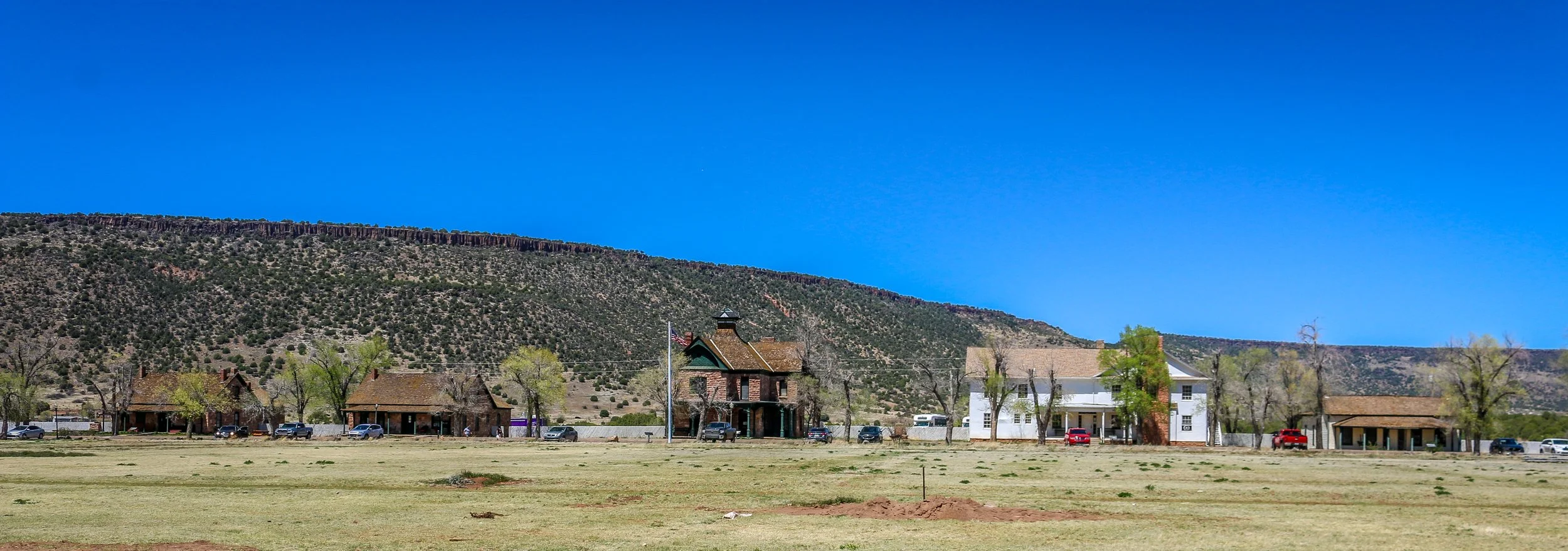
Fort Apache was constructed between 1874 and 1932 and served as an important military outpost during the Apache Wars. It rests in the midst of the beautiful White Mountains of Eastern Arizona. and is well situated at the convergence of the North and East Forks of the White River. The area is the ancestral home of the Cibicue and White Mountain Apache tribes who welcomed the United States Army to build the fort there, as they had a common enemy in the Chiricahua Apache. The White Mountain Apache are very proud of their service as scouts in the U.S. Army, and the role they played in the defeat of the Chiricahua and the capture of the great Chiricahuan leader, Geronimo. I learned a lot about the Apache Scouts and their campaigns at the wonderful "Nohwike' Bagowa" (House of Our Footprints), more commonly referred to as the Apache Cultural Center & Museum. which should be everyone’s first stop on any visit to Fort Apache.
After visiting the museum, I set off to explore the rest of the fort on a self guided walking tour which took in all of the wonderful historic buildings which remain on the post. After Geronimo’s capture in 1886, the fort remained an active military post for many years, finally closing in 1924 (although several Apache scouts remained in the army until 1947). After the army pulled out, the Theodore Roosevelt Indian Boarding School was established and the land was transferred to the Bureau of Indian Affairs as part of the White Mountain Apache Reservation. The school is still there and functioning today. I had a great visit with the kind and welcoming people of the White Mountain Apache band and really enjoyed my visit to this fascinating historic fort. I hope you enjoy these photos from Fort Apache.
Hello Everyone! When many of you will be reading this, Shadow Catcher and I will be celebrating the 4 year anniversary of this project. We set out together on November 11th, 2017 from our home base in Washington D.C. to Harpers Ferry, West Virginia. At the time, the plan was to spend a month in each of the 48 contiguous states, which, if done in one long stretch, would have put an end date right around now. I learned very quickly that a month isn’t very long when it comes to really getting to know a state and while I still try and move right along, six weeks seems like a more realistic timeframe. My dreams of financial success with this project have been all but a complete bust, so I have had to stop and go back to guiding to replenish my coffers. Thankfully, it’s a job I love and it’s fairly easy to put away money in a short time and keep going. And of course who could have predicted a global pandemic, which grounded us for 15 months at home? That time was a blessing as I got to spend it with my folks and watching young Mason every day on his journey from 2 to 3 years old. On the plus side, I’ve seen and done so much, learned more than I ever thought possible and met many truly wonderful people along the way. It’s been everything I hoped it would be and infinitely more and I’m grateful every day for this project, this journey, and all of you who have chosen to share in it. Like any journey, it’s had its ups and downs, but at the end of the day, I wouldn’t trade it for anything. As I wind up my time in Minnesota, my 16th of 48 states, that would leave me 1/3 of the way there. I don’t know if I’ll finish this project, but I’m definitely planning to keep going for the near future. Thank you all for coming along for the ride.
It’s been a very busy week blazing across the prairies of Southwest Minnesota. With daylight savings time ending and snow in the forecast, it is definitely time to start making an exit plan, but I didn’t want to miss out on a whole region. I’ve definitely driven more this week than I usually do and I’ve seen some pretty amazing places but it’s also been pretty fast and furious. That being said, I’ve driven past some fascinating things this week that either gave me pause or a good chuckle. When I drove through Brainerd again this week, I passed by the Warriors Early Childhood Learning Center. Their school team name is the Warriors, but to an outsider I thought this was pretty funny. I also drove past the towns of Nimrod, Sleepy Eye and Weetown – all of which made me smile. I saw a Sasquatch Reporting Station in Starbuck and a street called Oink Joint Rd. The Starbuck High School mascot is the Bucks, the Fergus Falls (county seat of Otter Tail County) is the Otters and of course in Pelican Rapids they went with… the Vikings! It was wonderful to see Amish buggies driving on the roads and tumbleweed tumbling down dusty city streets. It was a wonderful week of clear sunny days and I tried to make the most of it. Here’s what I got into:
When last I wrote I was headed clear across the state of Minnesota back to the western border. Along the way I stopped in the cute little town of Wadena to take some photos and have a wander. I ended up popping into the Little Round Still Distillery and talking with the nice folks there for a while. They gave me a lesson on Minnesota’s complicated liquor laws and it sounded like there is a lot to overcome when starting a brewery or distillery in the state. I ended up buying a 375ml bottle of their Gunflint whiskey which was quite good and the biggest bottle they could legally sell me. From Wadena, I headed on to the even smaller town of New York Mills to check out the Regional Cultural Center there. For a small town, this center is pretty well known and has a wonderful gallery and shop and hosts classes, workshops and events. There was a nice display of “wet felting” wall hangings by Kristen Anderson in the gallery when I was there which were beautiful and told an interesting story. There were also some other smaller pieces from previous exhibits upstairs. I was there for longer than I thought I would be but really enjoyed it. From there I headed on to Perham where I jumped on the Otter Trail Scenic Byway. This beautiful loop road took me through small towns and past some amazing prairie scenery as I made my way around Otter Tail County. I stopped in Pelican Rapids to take a photo of the world’s largest pelican and pulled into Phelps Mill right as the sun was setting to get some great photos of this historic mill now owned by the county. It was a great place to end my day and then I headed on to Fergus Falls for the night. I went downtown and found it pleasant but empty without a single bar or restaurant around. I really find it strange and sad when towns roll up their sidewalks after dark like that. I headed out of town and stopped for a quick beer at their brewery which was actually really tasty but way overpriced. I was sad that my only option for dinner at 8pm was Applebee’s which was on the low side of mediocre. For a town of 13,000 people I had expected a little more, but it was still a nice place to spend the night and it would redeem itself the following day.
Battle Creek was home to the Potawatomi people long before white settlers arrived in the 1820s. The completion of the Erie Canal brought a wave of people into Michigan seeking work in the lumber industry and the town of Battle Creek was formally established in 1839. During the antebellum period, Battle Creek served as a minor but frequent stop on the Underground Railroad and in 1857 abolitionist Sojourner Truth chose it as her new home where she would live until her death in 1883. In the late 19th Century, the Battle Creek Sanitarium opened as a health resort for the rich and famous. Some of its more famous guests were President Warren G. Harding, Mary Todd Lincoln, Thomas Edison, Amelia Earhart and Henry Ford. The manager of the Sanitarium was Dr. John Harvey Kellogg whose brother William also worked there. I’ve read several accounts of how they accidentally created their now-famous corn flakes, but however it happened, they were a hit. A lesser known guest at the Sanitarium, C.W. Post, took the cereal idea and ran with it, setting up his own Post Cereal empire in Battle Creek. Between Post and Kellogg’s, Battle Creek has taken the nickname Breakfast Capital of the World, or, less seriously, Cereal City. Because these two successful brands still call Battle Creek home, the city looks great. The downtown area is vibrant and full of unique artistic flourishes and beautiful murals. There is a wonderful walking path along Battle Creek River and some great bars and restaurants around as well. Although it was quiet when I was there, I really enjoyed my visit to Battle Creek and I hope you enjoy these photos from Cereal City.
Bay City, Michigan is clearly an old industrial town which once thrived on timber and shipbuilding, but which has reinvented itself as a modern and livable city on the shores of the Saginaw River. I enjoyed a scenic cruise on the river aboard the Princess Wenonah, a stroll past the timber barons houses on Central Avenue and plenty of time in the lively downtown core. I love towns that aren’t trying to cover up or destroy their past, but rather repurpose it in the modern world. In my time in Bay City, I’d say they are doing just that. I hope you enjoy these photos from Bay City, Michigan as much as I enjoyed being there.
Greenfield Village is an incredible outdoor living history museum located next to The Henry Ford Museum in Dearborn, Michigan. Greenfield Village was dedicated in 1929 as a school where neighborhood children and the children of Ford employees could learn in an authentic historic environment. It was opened to the public in 1933. Today, the museum has around a hundred buildings spread out over a vast campus. Some, like the Wright Brothers’ Cycle Shop, are the original buildings moved by Ford to the museum. Others, like the Martha-Mary Chapel, were purpose-built at the Village (the chapel actually used materials from Ford’s wife’s childhood home). There are wonderful interpreters and craftspeople spread throughout the Village to help explain the buildings and their roles in American history. I also loved the fact that Model Ts and horse-drawn buggies cruised the Village constantly (although rides are temporarily suspended for the general public). Some of the highlights for me were the Wright Cycle Shop, Noah Webster’s Yale House (where he wrote his famous dictionary), Robert Frost’s house from when he taught at the University of Michigan, the Cotswald Village (brought straight from England) and an Illinois courthouse where Abraham Lincoln once argued cases. As a historian and a photographer, this place was pretty awesome for so many reasons. I spent all day there and could have spent longer. Here are some of my favorite photos from my day at Greenfield Village. I hope you enjoy them. Let me know what you think in the comments below.
I had a wonderful Thanksgiving in New Hampshire last week and got out to do a little bit of exploring and to take these photos. It was lovely to drive around the small towns in the south of the state and I enjoyed seeing what they had to offer. Beautiful New England spires were ubiquitous, but I also found some stoic old industrial buildings and some incredibly still water to get some reflections shots. I hope you enjoy these photos from southern New Hampshire as much as I enjoyed taking them.
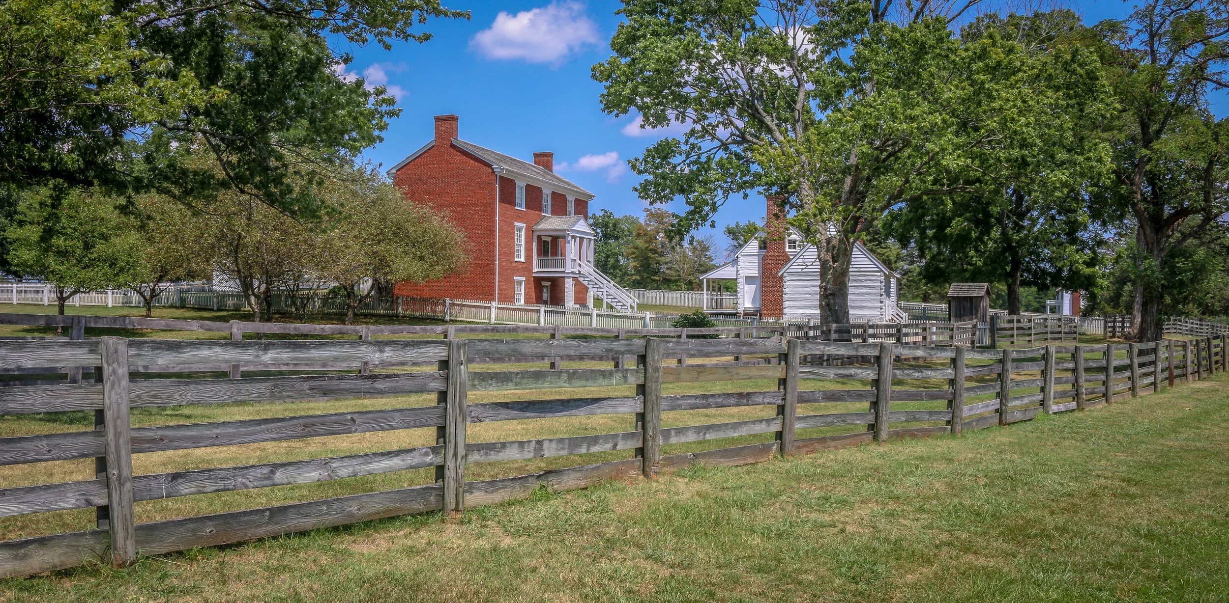
The photos below come from a recent visit to Appomattox Court House National Historical Park near the town of Lynchburg, Virginia. It was the site of the surrender of the Army of Northern Virginia which effectively ended the American Civil War.
After the siege of Petersburg and the fall of the Confederate Capital at Richmond, General Robert E. Lee led his Army of Northern Virginia west with the hopes of turning south to North Carolina and joining with General Joseph Johnson’s army there. They moved towards the train depot at Appomattox Station hoping to find much needed supplies waiting for them there. Union General Phillip Sheridan and his cavalry arrived first, capturing the supply trains and forcing Lee to turn his thoughts towards Lynchburg instead. Surrounded by Union troops, they made one final push at dawn on April 9th, 1865. It didn’t take long to realize that they were surrounded and Lee called for a meeting with Ulysses S. Grant to discuss the terms of surrender.
The site chosen for this conversation was the home of Wilmer McLean in the tiny village of Appomattox Court House. The generals met in the parlor, recreated above, to hammer out the details. The terms offered were very generous as the Confederate soldiers were to be immediately paroled and even allowed to keep their horses and sidearms. Their parole papers were printed in the nearby Clover Hill Tavern. The Southerners marched into town, stacked their rifles, turned over their cannons and marched out. While the surrender of Lee’s Army of Northern Virginia was not the end of the Civil War, there was little chance or hope for the Southern cause in its aftermath. The war would technically drag on until early summer, with skirmishes across the south, but the surrender at Appomattox Courthouse was the beginning of the end. Four long years of fighting which cost over 600,000 lives was finally nearing its conclusion…
The photos below come from a recent visit to the battlefields of the greater Richmond/Petersburg Area. With the exception of the first few from Gaines Mill which was important to the Peninsula Campaign of 1862, most of these battles were part of the 1864 Overland Campaign. This long, brutal and bloody series of battles would eventually lead to the capture of Petersburg and the fall of Richmond which set the stage for the surrender of the Army of the Potomac at Appomattox. Civil War Chronicles will trace the major battles of the Eastern Theater of the war through photos and brief histories
Richmond was not the original capital of the Confederacy, but became the capital after Virginia seceded from the Union in April of 1861. Richmond and neighboring Petersburg were major industrial hubs with rail lines connecting to points near and far and the James River to further move supplies in and out of the area. The rivers surrounding the city made defending it somewhat easier as well. Because of the strategic importance of Richmond, it would be the focus of several major campaigns during the war.
Our visit started at Gaines Mill Farm which saw some of the worst fighting of the Seven Days Battle during the Peninsula Campaign of 1862. This battle was the first in which Robert E. Lee had command of the Army of Northern Virginia following the wounding of Joseph Johnston. Lee’s ability to hold off George McClellan and his Union forces would direct the war away from Richmond and back to Northern Virginia to Fredericksburg and Chancellorsville which we visited several weeks ago…
Tenleytown grew up around the intersection of what are now River Road and Wisconsin Avenue, two roads which long predate both the city of Washington D.C. and the United States. River Road, in fact, predates European settlement to the area altogether, serving as a Native American trail to the Potomac River. In the early days of European settlement, the roads were used to transport goods from surrounding farms to Georgetown, then a major port city on the river. It is not surprising, then, that John Tennally, from whom the neighborhood takes its name, would build a tavern and blacksmith shop at the intersection of these historic roads. A small community soon grew up around the tavern and was known as Tennally’s Town. During the Civil War, Fort Pennsylvania was built nearby to protect the Capital City and was later renamed Fort Reno. After the war, a small African-American community known as Reno City was built in the area. When a streetcar came through at the end of the 19th century which connected Tenleytown to Downtown Washington, the neighborhood began to grow and flourish. Woodrow Wilson High School, Alice Deal Middle School and a water revoir and water tower were built, sadly displacing many of the residents of Reno City in the process. A proposed hospital on the site was never built. As the neighborhood developed, two major retailers, Sears and Roebuck and Hechinger’s Hardware Store, opened for business in Tenleytown and a Metro station further connected the neighborhood to the rest of the city. Today, Tenleytown is embracing its history as one of the oldest neighborhoods in what is now Washington D.C. with a wonderful historic walking tour and several historic plaques around town.
South Texas was the end of the road for me on this leg of my journey. I set out to make it across the country to the Pacific Ocean and back over the next 16 months or so, but the coronavirus put an end to all of that. When things started going from bad to worse further north, I made my way all the way south to South Padre Island and Port Isabel, stopping off at Palo Alto National Historical Park along the way. The battlefield was awesome to see and I had it almost entirely to myself. I learned a lot about the first battle of the Mexican-American War, and the two future presidents (Ulysses S. Grant and Zachary Taylor) who fought in it. The prickly pears were just starting to bloom, and the day was just on the verge of being too hot to be out in the sun. It was a beautiful and fascinating place. From there I headed to the coast and hunkered down for almost a week. While everything was pretty much shut down, I enjoyed the beach, sand art, peace and quiet and beautiful sunsets on the bay. When Shelter-In-Place orders came down for the beach communities, I knew it was time for me to head home, making this the end of the road for now. I was glad I saw it and had the chance to spend some time in this tiny, far out corner of America.
Port Lavaca is a lovely and quiet port town on Matagorda Bay and serves as the county seat of Calhoun County. Originally named simply La Vaca (“the cow”), the town was laid out in 1840 after Comanche raids forced people to abandon their homes in nearby Linnville. In addition to the port, the newly laid out town became the coastal terminus of a stagecoach route from Victoria, and eventually connected to the San Antonio and Mexican Gulf Railroad. In the early days, they did a fair trade in not just cattle, but also cotton, wool, pecans and precious metals. La Vaca lost its role as County Seat to nearby Indianola in 1852 but after a terrible hurricane hit the coast in 1886, it was moved back to La Vaca and remains there today. The port still plays a major role in the town’s economy, as do fishing and shrimping, but manufacturing employs many of the town’s residents today. I enjoyed my short stay in Port Lavaca with its charming downtown, beautiful marina and friendly people. I can see why locals refer to their hometown as “Paradise on the Bay”.
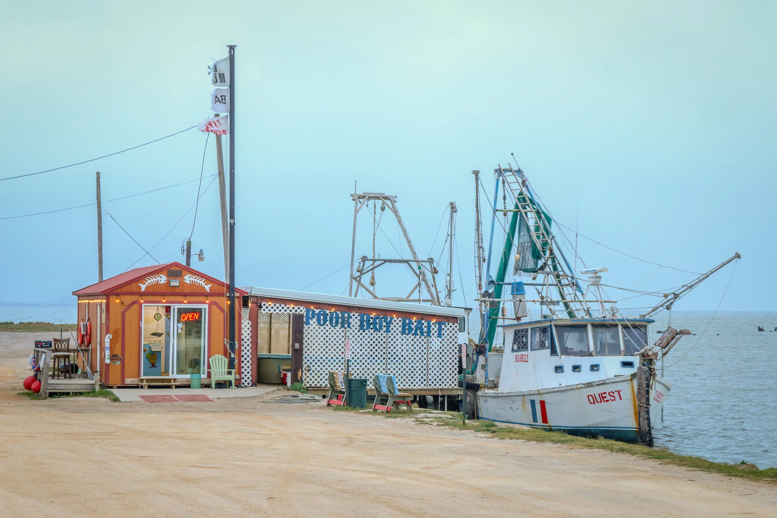
Originally home to the Karankawa people, Palacios was first settled by Europeans in the 1820s. In 1901, the land was purchased by a development company, divided into lots and sold to people looking to settle along the beautiful coast of the Gulf of Mexico. The Southern Pacific Railroad came through about the same time, providing overland access to the town-site. Over the next 20 years, the town grew as a resort community, and many businesses opened their doors to provide for the tourists flocking to the beaches. After World War I, a National Guard base called Camp Hulen opened nearby. The camp would be taken over by the War Department in World War II, eventually accommodating almost 15,000 soldiers. The base was also the site of a POW camp during the war. In the years following the war, Camp Hulen was closed and in 1961 Hurricane Carla slammed into the coast causing major damage. Today, Palacios is a quiet, pleasant seaside community of about 5,000. Home to about 400 shrimping boats, it has been called the Shrimp Capital of Texas. During my visit I found it quiet enough to enjoy its small-town tranquility but bustling enough to know it’s still alive and well. I had only planned on stopping for a few minutes to enjoy some sun by the water, and ended up staying most of the day, taking these photos, enjoying the views and chatting with the locals. I hope you enjoy these photos of Palacio, Texas, Matagorda County’s City by the Sea.