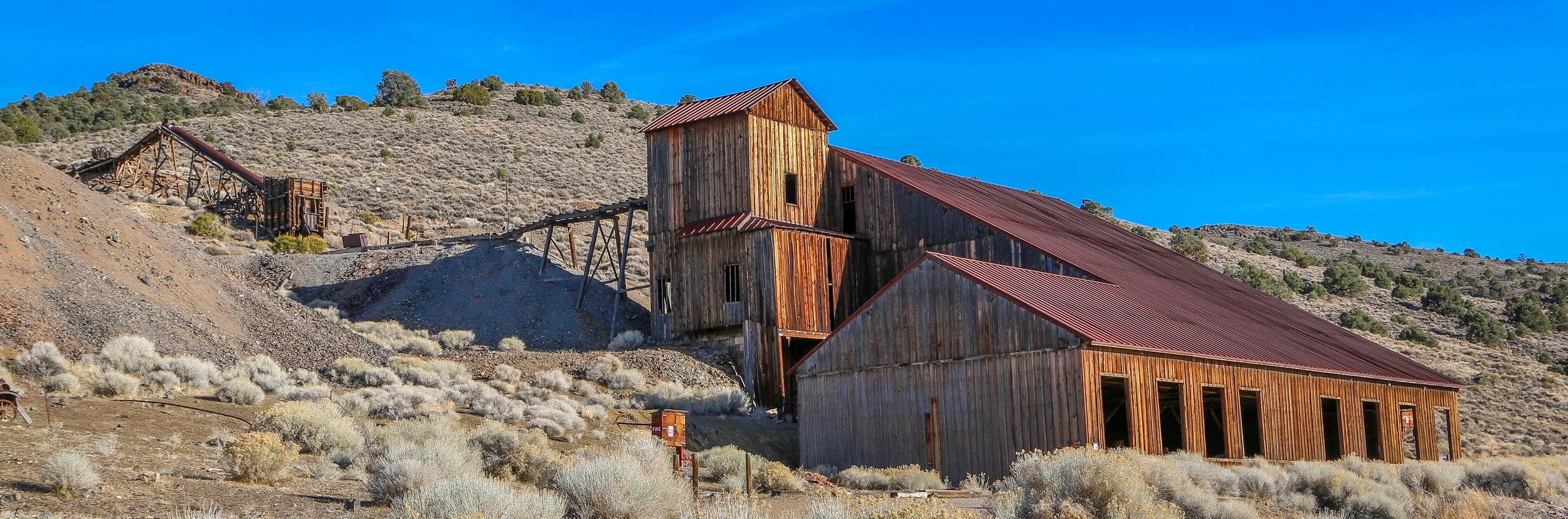
Berlin was established as a mining town in 1897 by German prospectors who named the town after the city in their native homeland. It had a small decade-long boom cycle but declined quickly after the Panic of 1907. By 1911 Berlin was virtually a ghost town and would begin to deteriorate. The land was acquired by the State of Nevada in 1970 to become part of Berlin-Ichthyosaur State Park. Since it was acquired, volunteers have stabilized the buildings and replaced the roofs and now it sits in a state of “arrested decay”. There are some great old buildings to see in Berlin, especially the massive stamp mill. I hope you enjoy these photos from the tiny old goldmining ghost town of Berlin, Nevada - definitely a cool place to see.
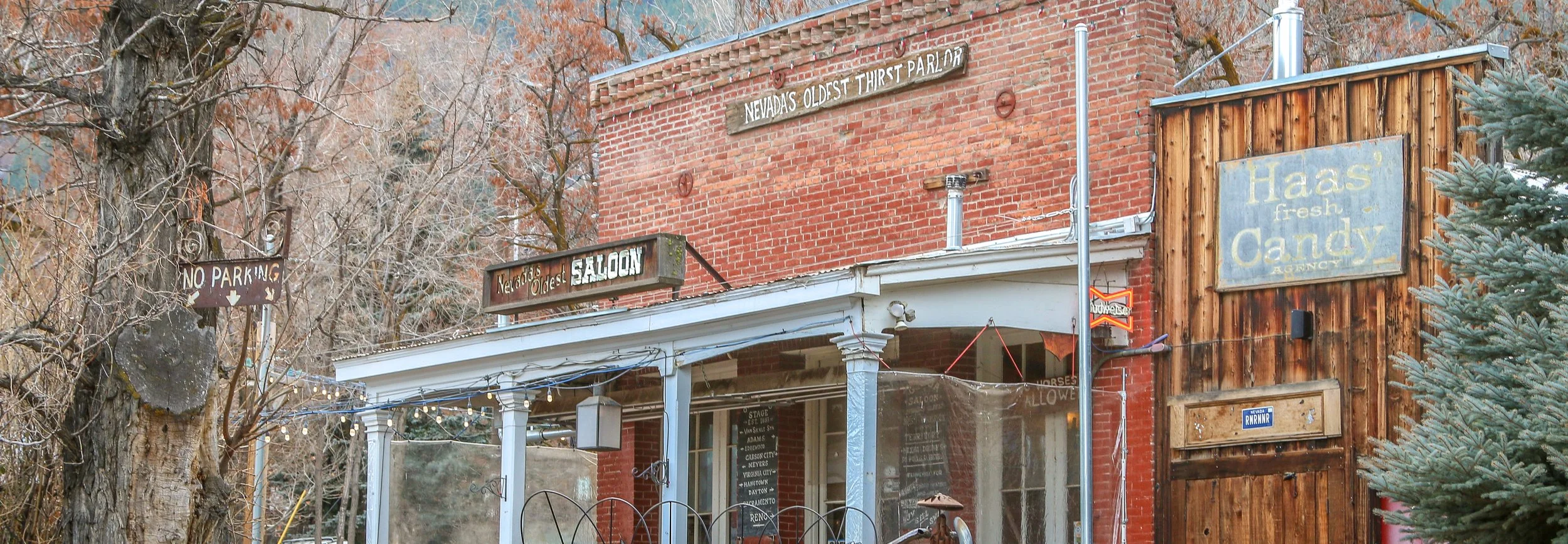
Genoa was first settled by Mormon pioneers in what was then the Mexican Territory of Alta California. Their settlement was known as Mormon Station and served as a roadhouse for westbound emigrants along the California Trail. After American annexation following the Mexican-American War, John Reese arrived and expanded the operation. Others soon settled in the area as well and the town started to grow. In 1856, the town was renamed after the Italian city of Genoa. The Genoa Bar was opened in 1853, making it Nevada’s oldest “thirst parlor”. Genoa was also home to Nevada’s first newspaper and served briefly as the capital city of the newly organized Nevada Territory. A beautiful brick house in town was built by “Lucky Bill” Thorington in 1855, but I guess his luck eventually ran out as he was the first man hanged in Nevada Territory. in 1919, Lillian Finnegan wanted to help the town purchase streetlights so she organized the Genoa Candy Dance to raise money, an event still held today over a century later to raise funds for the town. Genoa is a cool little place just a quick drive from Carson City and well worth a look if you’re ever in the area. I hope you enjoy these photos from Genoa, Nevada’s oldest town.
One of the west’s most fascinating historical figures to me has always been Chief Joseph of the Wallowa Nez Perce. Joseph was both a warrior and a peacemaker but ended up in an impossible position in 1877 after a treaty guaranteeing his band’s place in the Wallowa Valley was broken and four white settlers were killed by his people in the aftermath. He fled towards the Canadian border with his band but was overtaken just shy of the border. In the aftermath of what has become known as the Nez Perce War, the Wallowa band was resettled on the Colville Reservation in Washington which I visited late last year. Joseph traveled far and wide speaking on behalf of his people and never gave up hope of returning to his beloved Wallowa Valley. He spoke so fondly of it that I knew I had to go visit the area when I had the opportunity. What I found was a stunning valley, surrounded by mountains and ribboned with rivers and lakes, As soon as I descended into the valley I could see why Chief Joseph was so passionate about it. In addition to being their traditional homeland and the place where their dead are buried, it clearly provided them with everything they would have ever needed.
Nestled in the heart of the Wallowa Valley is the town of Enterprise, an adorable little mountain town founded in 1886 and now home to about 2,000 people. Enterprise is both the county seat of Wallowa County and the main supply town for the region. The railroad arrived in 1908 allowing the Eastern Oregon Lumber Company to form a few years later. Lumber is still a major player in the local economy and, along with the local ranching operations, helps keep the town afloat. I loved the little historic downtown core which is clean and well-kept, and dinner at the Range Rider was also a treat. I thoroughly enjoyed my time in Enterprise and the Wallowa Valley and I hope you enjoy these photos from my visit.
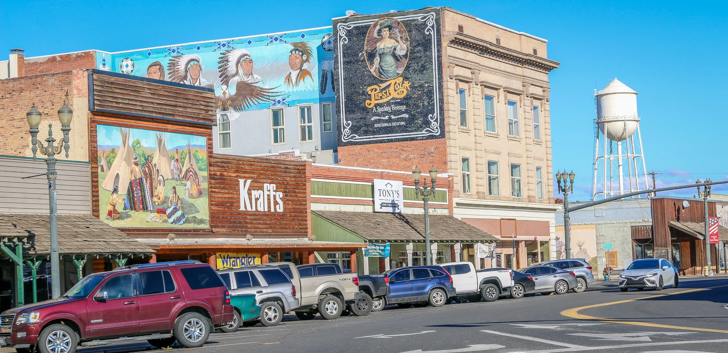
Toppenish is a cute little town with an Old West feel on the Yakama Indian Reservation in Southeast Washington State. It’s home to the wonderful Yakama Nation Cultural Center which was one of the better American Indian museums I’ve visited in the state. You can also find the Northern Pacific Railway Museum and the American Hop Museum which cover two of the main industries in the town’s history (both were sadly closed during my visit). Toppenish gets its name from a Yakama word meaning “landslide”. It is probably most famous for its 75 downtown murals which depict life in the valley between 1840 and 1940. I had a pleasant stay in Toppenish, and was treated to one of the best sunsets I’d seen in months while I was there. I hope you enjoy these photos from Toppenish, a town of museums and murals in Yakima County.
fell hard for Astoria during my stay in this classic Oregon town. I would say most people of my generation have seen the movie The Goonies, which is both set in and filmed in Astoria. It’s definitely one of my favorite childhood movies so I came here already having warm feelings towards the place, but it did not disappoint. There were surprises around every corner and even after a few days in town, I felt like there was still much more to be discovered.
Astoria was founded in 1811 at the mouth of the Columbia River just six years after Lewis and Clark cruised down the Columbia to the Pacific Ocean on their transcontinental adventure. That makes Astoria the oldest American city on the west coast. Originally Fort Astor, it was built by the American Fur Company to exploit the local fur resources of the region and named after the company’s founder John Jacob Astor. The fort would later be sold to Canada’s Northwest Fur Company and be renamed Fort George. The region would fall under joint American and British rule after the Treaty of 1818 but would eventually become a fully American town after the Oregon Treaty of 1846. With the decline in the fur trade, fishing would become the town’s major industry and the local canneries were humming 24 hours a day. The need for workers brought in many immigrants, notably from Scandinavia, China, Hawaii and the Punjab region of India. Fishing is still a major industry in Astoria today, but not like it once was. Tourism has played a big role in the local economy, and increased dramatically after The Goonies was released in 1985. Forty years later, there is still a steady parade of tourists making a pilgrimage up to see The Goondocks on the hill in Uppertown.
I loved all of the historic buildings, signs and businesses as I strolled the streets of Astoria. The history museum was wonderful and kept me occupied for several hours and the Flavel Mansion is a lovingly restored Victorian mansion and a real local treasure. Dead Man’s Isle tiki bar was a particular favorite while I was there, but I also really enjoyed the crowd at the Chart Room and Fort George Brewery. Blue Scorcher Bakery makes some delicious baked goods and definitely don’t miss the amazing tuna fish and chips at The Bowpicker which is cooked on an old boat and has a line whenever it’s open - it’s worth the wait. Astoria felt like a town that has a plan and works to implement it and the local identity is a strong one. It’s location near the coast and its proximity to Portland bring in a steady stream of tourists and keeps the town bustling throughout the year. This was my first time in Astoria, but it definitely won’t be my last. I hope you enjoy these photos from the amazing little city of Astoria.
Rockaway Beach is an adorable little beach town in Tillamook County on the Oregon Coast. A train from Portland brought visitors to this charming destination long before the coastal road was built and today a brightly painted caboose welcomes you to town. You can still ride the train as well, but only as far as Garibaldi on the Oregon Coast Scenic Railway. Rockaway Beach is also home to Pronto Pup, which claims to be the originator of the corn dog. The Twin Rock Arch is visible from anywhere on the beach and is quite a beautiful formation to see. I loved Rockaway Beach at first sight and ended up staying the whole day, soaking up some rays and enjoying the small-town charm of this great beach spot. It was such an easy place to pass the time, which I imagine is why it’s been such a beloved destination for as long as it has. If you’re ever traveling up or down the coast, be sure to carve out some time for a visit. I hope you enjoy these photos from my time in Rockaway Beach.
Bandon is an adorable little town of about 3,300 people on the southern Oregon coast. Originally Coquille Indian land, it was first settled by people of European decent in 1853. The town was established in 1873 by four men from Bandon, Ireland in County Cork and named for their old world home. Cranberries were introduced into Bandon in 1885 by Charles McFarlin of Massachusetts and have been grown and harvested successfully in the area ever since. Tragically the whole town burned to the ground in 1936 in a fire that claimed eleven lives. It has risen from the ashes and rebuilt as a charming coastal town with a lot to offer.
Bandon was probably my favorite town on the whole Oregon coast. The Old Town area was full of art and color and I loved just walking up and down the waterfront. The beaches were absolutely stunning with so much more to see than just the famous Face Rock and an evening stroll proved to be an excellent choice. The history museum, housed in the old City Hall, was one of the best local history museums I’ve ever been to in a town this size. Of course I loved the hand-painted signs around town, the beautiful carved wooden sculptures and the Coquille River Lighthouse. Of all the towns I visited in my first week along the coast, this was the one that stood out and a town I will definitely return to. Thank you, Bandon, for a wonderful stay. I hope you enjoy these photos from Bandon, Oregon.
I have really been looking forward to visiting Ferndale, the Victorian village in Humboldt County, and it was so much more than I ever imagined it would be. This charming town is over the river and down the road from the main highway and while it’s definitely not a secret it still kind of feels like it is.
Ferndale got its start back in 1852 when brothers Stephen and Seth Shaw came to the area to claim a homestead and begin farming. They found that the land was particularly suitable to raising cattle and a small dairy community would begin to grow. William would eventually leave the area, but Seth remained and built a beautiful Gothic home, which he called Fern Dale. When a post office opened in the area, the name was adopted for the town. That house is now called Shaw House and is still there to see in all its Gothic glory.
Dairy, and especially butter, would be the main industry of the town for quite some time, and a process of cutting and wrapping butter in paper for transport was pioneered in Ferndale. Once this process had been developed, butter was shipped down the Eel River and sent south to San Francisco and the town would grow. Butter brought wealth to the area and many fine homes and buildings were constructed in the Victorian style of the time, often called “Butterfat Palaces”. I’m thrilled that so many of these buildings have survived and dairy continues to be the main industry driving the local economy.
I spent a couple of days in Ferndale, taking these photos. I found the locals to be friendly and welcoming as one would expect in Northern California. I particularly enjoyed a conversation about the upcoming Humboldt County Fair one night in the Palace Saloon and also attending an Old Timers’ baseball game at the local ballfield. Breakfast at Joe’s Place was top notch and I loved being able to enjoy a glass of local wine above the bar in the Gazebo. Taking these photos was a joy, especially of the Gingerbread House, Gazebo, the Victorian Inn and the beautiful lamp posts around town. I hope you enjoy these photos of fabulous Ferndale, a town full of Victorian charm in the heart of Humboldt County…
Vitus Bering claimed Alaska for the Russian Empire in 1741 under orders from Tsar Peter the Great. Russia’s hold on Alaska would last until they sold the territory to the United States in 1867 and their primary focus was on the abundance of valuable furs found in Alaskan waters. The most enduring legacy of Russian culture in Alaska is the strong presence maintained by the Russian Orthodox Church in the state. This summer I had the pleasure to visit these four beautiful Russian Orthodox churches, three in the Kenai Peninsula and one in Anchorage. As someone born into and raised in the Russian Orthodox faith, I found it fascinating to visit these churches and I was thrilled (or, perhaps, blessed) to see them all on sunny days. I hope you enjoy my photos.
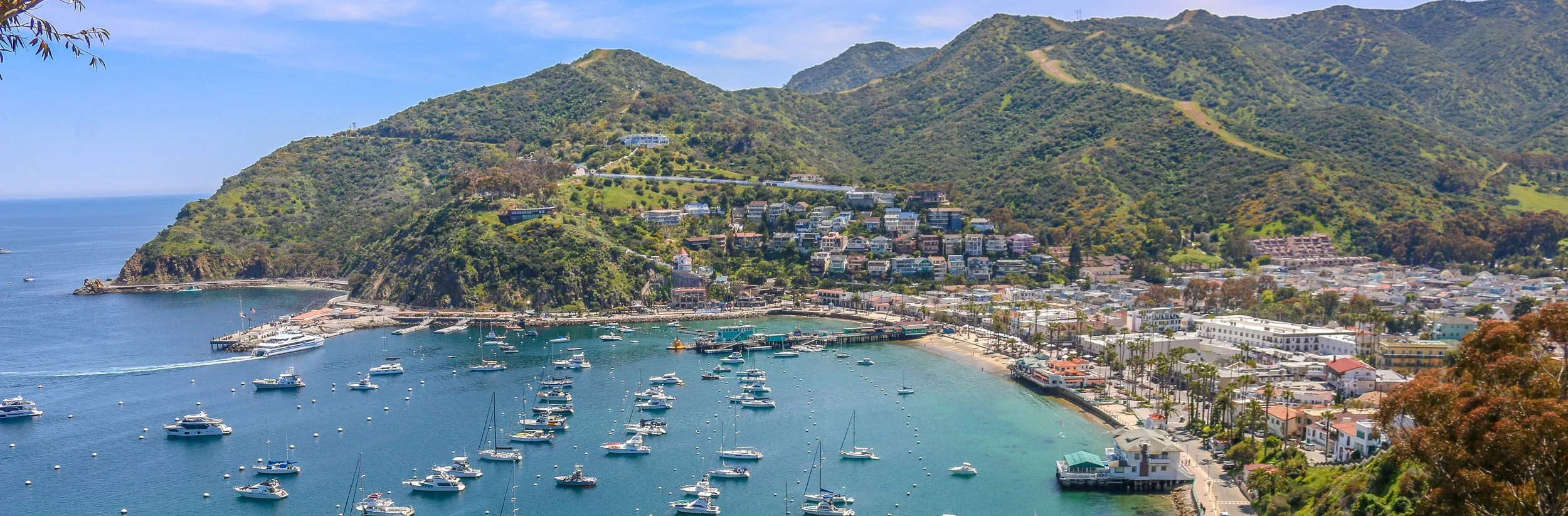
Avalon! Just hearing the name of this magical place will always make me smile. Avalon is the only town in California’s beautiful Channel Islands and is located on the easternmost island of Santa Catalina, just a short hour’s ferry ride from the mainland. It may be only an hour away, but it is a world apart and landing at the port feels like you’ve arrived in a far off land.
Catalina Island was once home to the Tongva people who used the island’s abundant soapstone to trade with other bands on the mainland and the other islands. It was purchased in its entirety by James Shatto in 1887 and Shatto built the island’s first pier and hotel hoping to attract tourists from Los Angeles. He had a tough time of it though and sold the island to the Banning Brothers just four years later. They had some level of success in developing the island’s tourism potential, but a devastating fire in 1915 and the general decline in tourism due to World War I caused them to look for a buyer themselves.
The man they found was William Wrigley Jr. of Wrigley Chewing Gum fame who purchased the island from the Bannings in 1919. Wrigley had the capital and the drive to make Avalon and Catalina Island a success. Wrigley built the Casino which is a theater, ballroom and gathering place and has never been a gambling hall. He purchased steamships to bring people to the island and built hotels to house them and restaurants to feed them. Wrigley owned the Chicago Cubs and had the team hold their spring training on Catalina from 1921-1951. Tourists came in droves, including many Hollywood stars.
After William Wrigley’s death in 1932, his son Philip took over and continued to promote Avalon and Catalina Island. During World War II, the island served as a training facility for the military, but after the war tourism would continue to grow. Philip was sensible enough to think of the long-term health of the island and signed over 88% of the island’s land to the Catalina Island Conservancy in 1975 to be kept in its natural state in perpetuity.
I had a great time in Avalon. I enjoyed some beach time at Descano Beach under the palm trees where I also tried the island’s signature cocktail: Buffalo Milk. I toured the Casino and saw the world’s largest circular uninterrupted dance floor. Our guide told us stories about the heard of bison which was brought to the island for the filming of Zane Grey’s The Vanishing American in the 1920s. They were left on the island and now roam free in a herd of over 150. We learned how Norma Jean Dougherty moved to the island when she was 16 and married a naval enlisted man. She worked pulling taffy at Lloyd’s Candy Shop (which is still there) and her husband was a projectionist at the Casino. Years later the world would meet her as Marilyn Monroe, but the island still remembers her as Norma Jean. An exotic bird park on the island was used to record the sounds used for the flying monkeys in the Wizard of Oz. The stories went on and on, one more interesting than the next. I learned more island stories at Avalon’s wonderful history museum and enjoyed a wonderful fresh fish dinner at the Lobster Trap and delicious strawberry pancakes at the Pancake Cottage the next morning. I climbed up the hill to the beautiful Chime Tower which chimes the quarter hour and provides amazing views over the town. I was only there for a day and a half, but I felt like it was much longer. I will always remember my time on beautiful Catalina Island and will definitely return in the future. I hope you enjoy these photos from Avalon, the jewel of Catalina Island.
Most of the states I’ve been to seem to have a town like Solvang - a place with solid European roots that has developed into a tourism draw over the years. Some of my favorites have been Helen, Georgia, Frankenmuth, Michigan, New Ulm, Minnesota and Helvetia, West Virginia. All of these have had either a German or Swiss background, which made the Danish village of Solvang different and quite fun for me to explore.
The area where Solvang now stands was originally Chumash land. In 1804, the Spanish built Mission Santa Inés, one of 21 Catholic missions they would establish in Alta California to try and convert the native peoples and help the Spanish claim to the territory. After Mexico won its independence in 1821, the mission system was dissolved and the land was divided into land grants and this area became part of Rancho San Carlos de Jonata.
Beginning in 1850, many Danish immigrants began arriving on America’s shores including some of my ancestors on my father’s side. Communities would begin to form, especially in the Midwest. In 1910, a small group of Danish men decided to try somewhere a little warmer and purchased land in the Santa Inés Valley. A year later, a town plan had been drawn up and Solvang was born.
Originally, the town looked like many others in the region but after World War II many buildings were built or rebuilt in a more Scandinavian style. Today, Solvang is definitely an eye-catching place, especially the windmills which are scattered around the town. Tourism is a major draw with people coming from all over the world to visit the delicious bakeries and restaurants.
I had a great time in Solvang. It was busy but not crazy and I couldn’t help but smile as I wandered around taking these photos. It felt familiar yet different at the same time and it is definitely worth a visit if you’re looking for a break from the coastal beach towns and Mission architecture. I hope you enjoy these photos from beautiful Solvang, California’s Danish capital.
If there’s a more classically Californian beach town than Pismo Beach, I have yet to find it. Just driving into town makes your stress start to fade away and when you find a parking spot you can take a deep breath and relax - you have arrived. Pismo Beach residents have made an obvious effort to create and maintain this laid-back, surfer vibe and they’ve built a beautiful town around it. The fact that I was there on a beautiful sunny day didn’t hurt.
This area is historically home to the Chumash people, and “Pismu” was their name for the tar they found in the area which they used to seal their canoes and baskets. The Spanish Portolá Expedition passed by the beach in 1769 and after Mexican independence it would be included in José Ortega’s Rancho Pismo. A town was established in 1891 and the first pier was built in 1924. Pismo Beach was long called the “Clam Capital of the World” and these delicious mollusks drew people from miles around, but overharvesting has devastated the local clam population. Today the town states simply that they are “Classic California” and they definitely live up to that claim. While there is a lot more to California than surfing and beaches, that is the image that many people have of the Golden State. If that’s what you are looking for, you won’t find a better place to experience it than beautiful Pismo Beach. I hope you enjoy these photos from this classic California surf town.