Hello Everyone! I am slowly but surely making my way through my Alaska photos. I have one more set to get through which I hope to look at this week. The photos in this post come from another tour I led to Denali and Seward, a personal adventure to Homer and to look for the old Russian Orthodox churches in the Kenai Peninsula and a few others which I took along the way. Meanwhile, I am back in California about to run my last trip of the season. I’ll be heading home to D.C. for a while after that and I will definitely be getting some work done from home. Expect plenty more photos in the near future and then I really hope to be back to blogging and taking photos full-time in early 2025. Thank you for reading and I’ll be back really soon.
-Mike
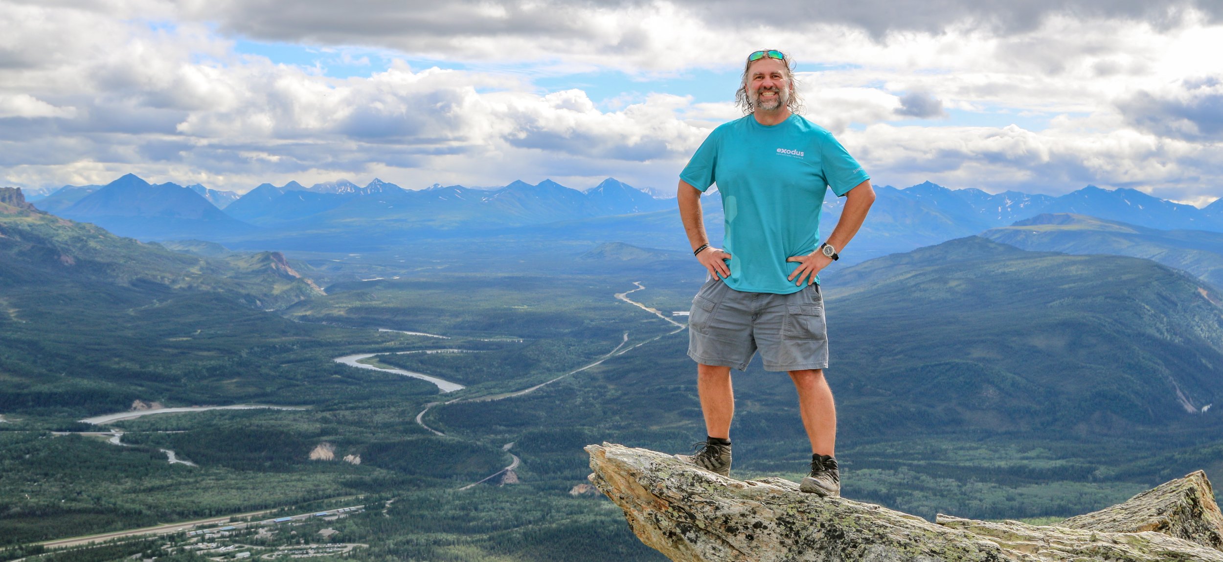
Hello Everyone! It has been a heck of a summer in Alaska, the first I’ve spent in The Last Frontier since the pandemic. I’ve been crazy busy running camping tours so I haven’t had any time to get to these photos at all, but now that I’m back in the Lower 48 I hope to get through them so I can share them with you. This next batch comes from my July tour - an Alaska Wilderness and Wildlife camping adventure which I ran for Exodus Travels. It was really a wonderful trip and I even had an old friend join me who went on tour with me many years ago. We had a nice journey to Denali National Park and had some crystal clear views of the continent’s tallest mountain - something only 30% of visitors to the park get to see at all. From there we headed down to beautiful Seward, one of my favorite little towns in the country. We had a nice boat tour out into Kenai Fjords National Park to spot whales and sea lions, puffins and eagles and so much more. And then we lucked into another clear and sunny day to hike to the Harding Icefields in the inland portion of the park. We rounded out the tour with some rafting on the Kenai River, a little gold panning and a few pleasant if lesser-known hikes in the Cooper Landing area...
I absolutely love Joshua Trees. Much like the Saguaros are iconic to the Sonoran Desert, the Joshua Trees are iconic symbols of the Mojave Desert and it’s too easy to imagine human characteristics in both. Every time I pull into an area with Joshua Trees it makes me smile and feel happy. Interestingly, Joshua Trees aren’t really trees at all, but rather a tree-like member of the yucca family. They may have been given their name by early Mormon pioneers who thought they resembled the Biblical Joshua with his arms raised.
It is believed that people have been living in the region of Joshua Tree National Park for 10,000 years. The first people of European descent who laid eyes on the area were with Spaniard Pedro Fages who was pursuing Native Americans who had “escaped” the mission in San Diego. After the Mexican-American War, American settlers started moving in, building ranches and doing some small-scale mining. Franklin Roosevelt protected the area as Joshua Tree National Monument in 1936 and it became a National Park in 1994. The park covers 1,242 square miles - slightly larger than the state of Rhode Island.
I’ve visited Joshua Tree National Park several times before, but always in the middle of summer when it was boiling hot out. We might get out and take some photos, but long hikes were pretty much out of the question. I was really happy to get there this past spring when it was cool and pleasant and I could get out on the trails. I hiked the Short Loop Trail from Black Rock Campground, Ryan Mountain, and the Lost Horse Mine Loop among others and they were all fantastic. Joshua Tree National Park is a special place and while it doesn’t get the hype of our other western National Parks, it’s definitely worth a visit. I can’t wait to return. I hope you enjoy these photos from beautiful Joshua Tree National Park.
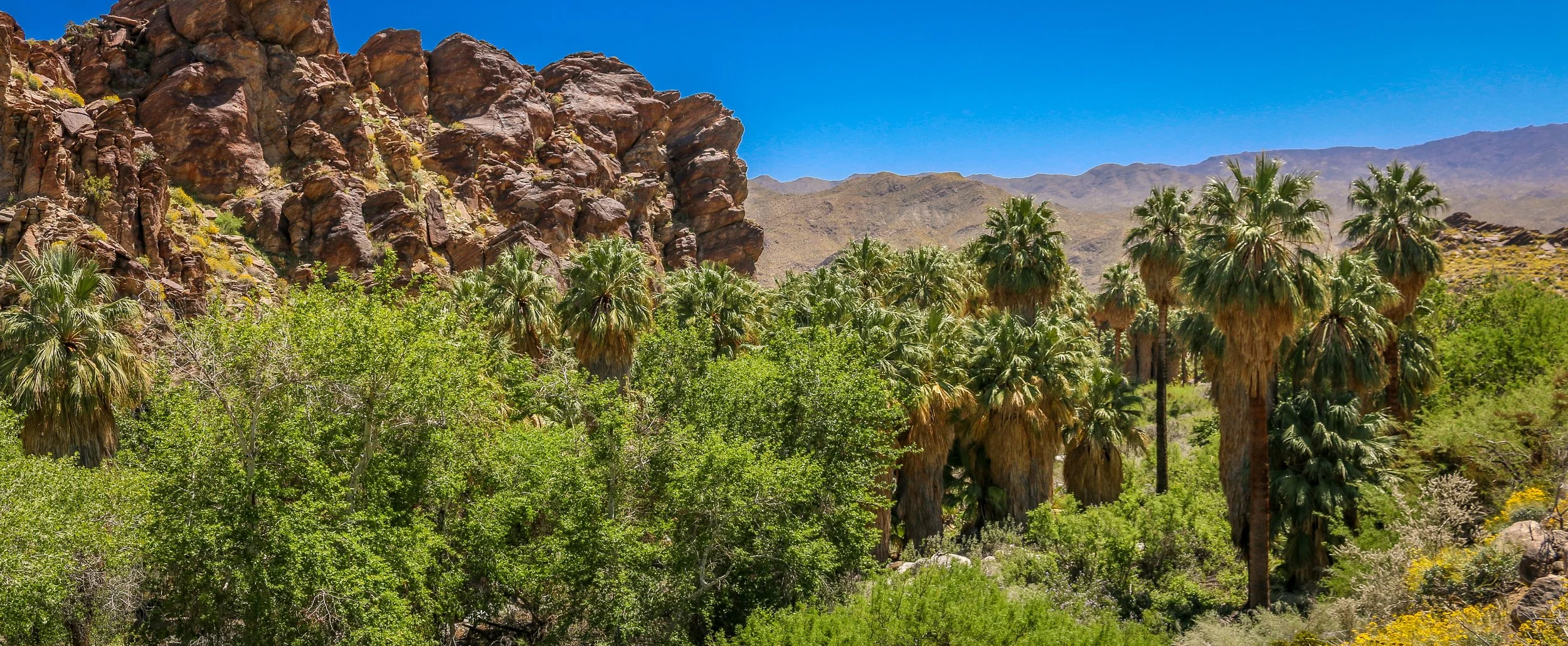
The natural oases of the Indian Canyons near Palm Springs have been home to the the Agua Caliente Band of Cahuilla Indians for a very long time. They had abundant water and were able to plant and harvest melons, corn, beans and squash. Today they welcome visitors to their homeland to hike, relax, and enjoy the natural beauty of the world’s largest California Fan Palm oasis. I was lucky to be there in the middle of a particularly wet spring and the wildflowers were absolutely stunning. Palm Springs didn’t do much for me, but I’m definitely glad I got to visit the magnificent Indian Canyons just outside of town. I hope you enjoy these photos of the super bloom in this wonderful desert oasis.
Hello Everyone!
I hope your summer is starting out as great as mine is. The summer solstice is upon us and I’m trying to make the most of the long days. This week I’ve been guiding a trip for two wonderful ladies from San Francisco to Las Vegas via Yosemite, Death Valley, Zion, Bryce, Monument Valley and Grand Canyon. While I definitely prefer guiding a larger group, the three of us have clicked well and have been having a good time out here. We’ve had some windy days, but they’ve also been sunny and bright and of course these parks are truly magical places to spend time.
We left San Francisco early Monday morning and made a beeline for Yosemite. I was happy that route 120 was open again after being closed due to road damage on the final decent into the valley. That closure caused me to detour around to the 140 on my last two trips, which added about an hour to the drive and threw my regular route, landmarks and commentary out the window. It was nice to do things a little differently for a change, but I was happy to fall into my familiar groove on that drive this week. Unfortunately by the time we were dropping into the valley in the afternoon, it had clouded up and there was some rain falling. This should be quite normal for this time of year, but after 20 years of drought it doesn’t feel normal. El Capitan was in the clouds and Half Dome wasn’t even visible. Thankfully the waterfalls were going strong and we stopped at a couple of viewpoints to check them out. The rain slowed to a drizzle and we spent the rest of the afternoon wandering around the old Ahwaneeche village behind the visitor center and visiting Galen Clark’s grave in the old cemetery. Clark came to the valley in 1851 after being diagnosed with consumption (tuberculosis) and having been given just a few months to live. He fell in love with Yosemite and decided to dedicate the rest of his life to preserving it. That life was supposed to be short, so he dug his own grave and planted Giant Sequoia saplings around it. He ended up living another 54 years but was eventually buried in the grave he dug for himself. After I told that story and we paid our respects, we headed to our hotel out in El Portal for the night.
We returned to the valley on Tuesday morning under blue skies and sunshine. Linda wasn’t convinced her knee would hold up on long ascents or descents, so we stayed on the valley floor for the day. We went out to Mirror Lake in the morning which was as full as I’ve ever seen it (it turns into Mirror Meadow pretty early in the summer most years). Then we wandered back to the Ahwanee, Yosemite’s classic park lodge. We had lunch in the Great Room and a nice chat about the afternoon. From there we made our way out to Lower Yosemite Falls which is still raging pretty hard right now and putting out plenty of spray. It’s awesome to spend some time there and the ladies really enjoyed it. Then we headed back to Yosemite Village for a coffee and then back to our hotel for the night.
Wednesday was kind of a quiet day. We chose a late start and then made our way down to the Mariposa Grove of Giant Sequoias. The shuttle is finally running again, cutting out the 4 mile roundtrip hike to the grove from the parking lot. We enjoyed our visit to the big trees and then spent some time in historic Wawona, checking out some of the cool old buildings from Yosemite’s past. In the afternoon we returned to the valley for a quick coffee and then made our way back to the hotel. I’d been eating salads for a few days so I decided to grab a pizza which was nice. My knee was giving me some trouble too so I was grateful to be able to ice it and rest for the night.
Since the Tioga Pass over the Sierras is still under many feet of snow and likely won’t open until August, I had to make the long drive around the mountains to get to Death Valley on Thursday. Not only is this route far less scenic, but it also adds 2-3 hours to the drive. It wasn’t a fun or beautiful drive except at the very beginning or the very end, but we got there. I haven’t been to Death Valley in years, and we were greeted with a cool 107° when we arrived…
The Channel Islands are an eight island archipelago off the coast of Southern California and five of these islands make up Channel Islands National Park. The waters surrounding these islands are also protected as a National Marine Sanctuary. The Channel Islands were created by tectonic forces 5 million years ago and have always been islands, although they were closer to the mainland during the last ice age when the sea levels were lower. Because of their isolation, the islands are home to several endemic species of plants and animals meaning those found nowhere else on Earth.
People have inhabited these islands for a very long time. In fact the oldest human remains ever found in North America, dating back 13,000 years, were discovered on Santa Barbara Island in 1959. In more recent times, the northern islands were home to different bands of the Chumash people while the southern islands were inhabited by the Tongva. Juan Cabrillo observed the islands on his 1542 voyage up the coast and in more modern times the islands were used to raise sheep and cattle. They were protected as a National Park in 1980.
I was unfortunately only able to visit one of the islands in Channel Islands National Park during my stay, but Santa Cruz is the biggest and most accessible and made for a wonderful visit. I stayed in the campground at Scorpion Ranch for three nights and was able to hike to Cavern Point, Smuggler’s Cove, Potato Harbor and the incredible Montañon Ridge. For the last two days I was on the island, there were only 19 other people there which made for a peaceful and incredible stay. It was hard to believe that we were only an hour car ride and an hour ferry ride from the second largest city in the country, but it sure was nice to be there. I can’t wait to go back again. I hope you enjoy these photos from Channel Islands National Park.
The formations in Pinnacles National Park are thought to come from the western half of the Neenach Volcano which erupted 23 million years ago. Between then and now, this geologic formation is believed to have shifted almost 200 miles north and west thanks to plate tectonics.
This area was originally inhabited by the Ohlone people. Spanish missionaries established a mission at Soledad in 1791, just about 5 miles from the park’s current boundary. When American settlers moved into the area, they referred to the formations as “the Palisades”, and investors once considered putting a resort hotel at their base. The area was first protected as Pinnacles Forest Preserve in 1906 and then as Pinnacles National Monument in 1908. It became a National Park in 2013.
I had a great day in Pinnacles during my visit to the west side of the park. It had been raining for days and it was nice to see some blue sky for a change. I arrived early and was able to park in Bear Gulch, although there is a shuttle to bring people up from the Visitor Center as well. From there I hiked up the Condor Gulch Trail to the High Peaks Trail and then returned on the Bear Gulch Trail to the parking lot. It was a wonderful 6-7 mile loop through the pinnacles and provided great views in every direction.
The highlight of my day was definitely seeing the endangered California Condors which call the park home. I saw no fewer than 6 of them, which would be around 2% of the entire wild population of California Condors in the world. Some came so close I could’ve touched them if I’d have been sitting on your shoulders and I had never seen condors so close before. Watching them in flight is a truly special experience as they are enormous and cover a tremendous area in a short time. They move so quickly that they are tough to photograph, but there is one in the photo directly below. The condors alone were worth the visit, but I had aa awesome hike as well and it was reasonably quiet while I was there. While Pinnacles is one of the lesser known national parks in California, and for good reason, it is still a wonderful place to visit and worth a stop if you are in the area. I hope you enjoy these photos from Pinnacles National Park.
Hey y’all. I just wanted to share a few of my favorite shots from my time on the North Rim of the Grand Canyon. I’m doing this as a Snapshots post instead of an In Focus post because I’ll make one for all of Grand Canyon later this summer, but with any luck I will get down to Phantom Ranch between now and then, making it somewhat more complete. But I promised you some Grand Canyon photos before I transitioned to more recent California shots next week, so here you go. Enjoy!!
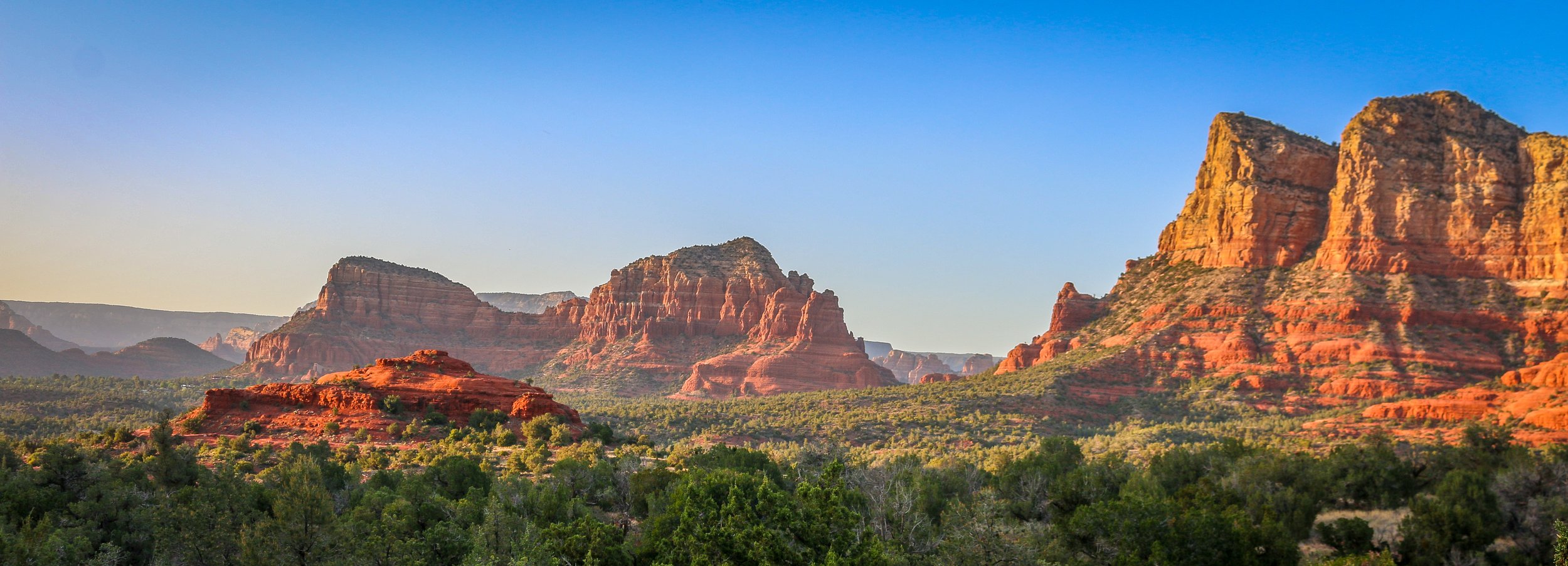
I had spent time in Sedona before, but never enough. I was always there for just a night, usually late in a tour where we didn’t have much time to do more than have a cursory look around. The cost and snobby attitudes of the locals with their spiritual vortex talk was always a turn-off for me. I had never had the chance to really get out there and do some hiking before, but I’m sure glad I scheduled a few days for it on this trip. I’ve been to a lot of places in this country, but few can compare to the red rock country surrounding Sedona. I don’t know about vortexes, but it is definitely a beautiful and magical place. Like most of red rock country, it’s best to hit the trail very early in the morning or just as the sun is starting to go down. While I was there, I hiked to the Birthing Cave, the Subway, Devil’s Bridge, the Courthouse and Bell and, my personal favorite, the Airport Loop. With the exception of this last one, which I had all to myself, there was no shortage of people in the area. It’s definitely not a secret place, nor is it off the beaten path, but it’s well worth it to visit and the shear number of trails in the area helps to disperse people pretty well. I had a wonderful few days in Sedona and will definitely be back. I hope you enjoy these photos from beautiful Sedona, Arizona, a true hikers’ paradise.
Organ Pipe Cactus National Monument was one of the top spots on my list of places to visit during my time in Arizona. It’s a remote park, located two hours from anywhere and right on the U.S./Mexican border, but it’s the only place in the country that you can find naturally occurring organ pipe cactus. In addition to these beauties, there are so many other species of cactus and desert plants as well which has led to this region also being named a part of UNESCO’s International Biosphere Reserve.
Organ Pipe Cactus was made a National Monument by Franklin Roosevelt back in 1937. A special act was passed to allow mining in the area during World War II, an act which sadly wasn’t repealed until 1976. The park’s remote location on the Mexican border used to bring both drug runners and human smugglers through the area, making this America’s most dangerous park. This danger is memorialized in the Kris Eggle Visitors Center which was named for a park ranger who was killed protecting visitors from drug smugglers in 2002. In the wake of his death, the border was reinforced and I felt safe there during my stay.
It was unbelievably hot when I arrived on an afternoon in late April. So hot that I couldn’t actually do anything but hover in the shade of the restroom and wait until the sun started to go down. I did enjoy a wonderful evening hike and an early morning one the following day as well. The area is beautiful and it was great to see the Organ Pipes in their native habitat. It was definitely just a one night stop, but I’m very glad I went. I hope you enjoy these photos from Organ Pipe Cactus National Monument.
There may be no more iconic plant in the United States than the stately and stoic saguaro cactus. These beautiful cacti can grow up to 40’ tall and live to be 150 years old. They won’t start growing arms until they are 75 years old and some will grow many arms in their lives. Most of the natural habitat of the saguaro is in the Sonoran Desert which straddles the U.S./Mexico border.
In 1933, President Herbert Hoover designated Saguaro National Monument which we now call the Rincon Mountain District of the park. In 1961, John F. Kennedy added the Tucson Mountain District to the Monument and in 1994 these two tracts were combined into Saguaro National Park.