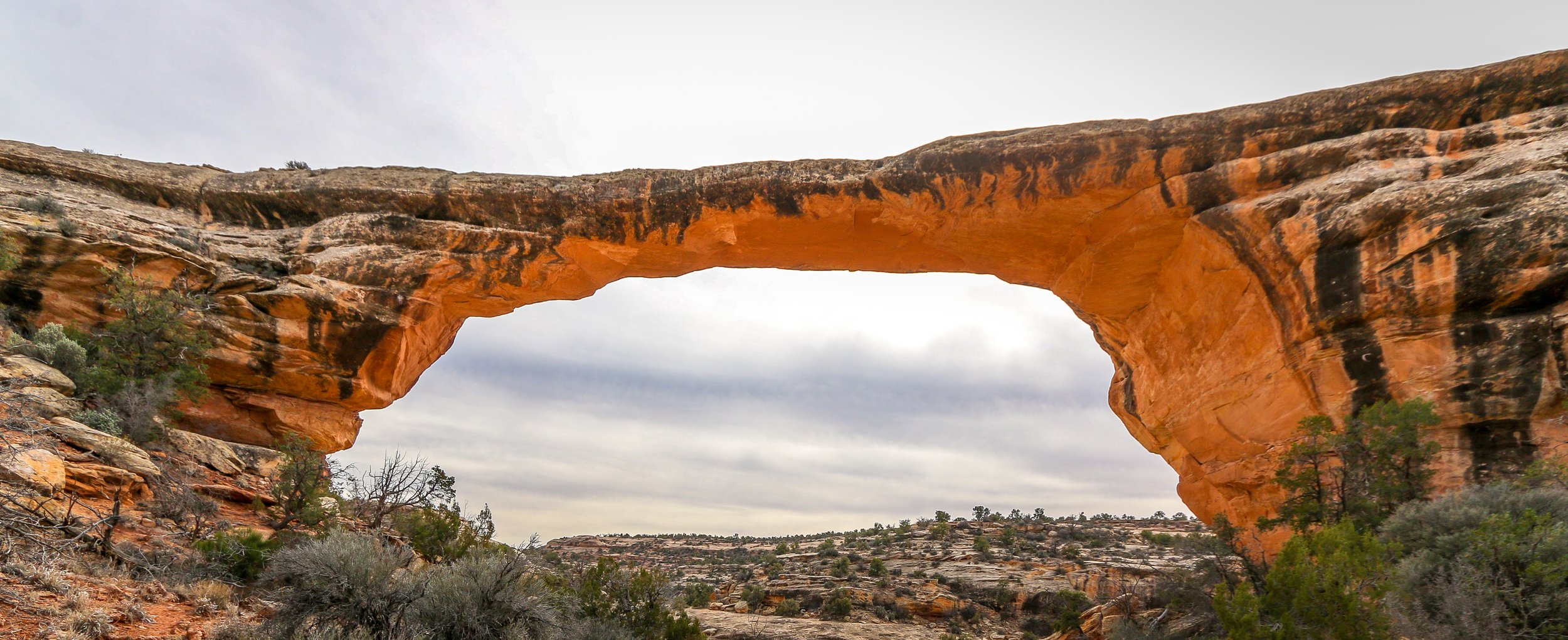
Natural Bridges National Monument became Utah’s first National Monument in 1908. It protects three impressive natural bridges situated in White and Armstrong Canyons in the southeast part of the state. A natural bridge is geologically different from an arch in that a bridge is formed by running water whereas an arch is not. Utah has quite a few of both.
The human history of this area stretches back at least 9,000 years as archaeologists have found tools and other evidence dating to that time. Ruins in the park show that the Ancestral Puebloans inhabited the area from around 700AD to around 1270AD. In more recent times, Paiute and Navajo people have made their homes in and around these canyons. in 1883, a man named Chris Hite wandered up White Canyon in search of gold and brought word of these magnificent natural bridges to the outside world. National Geographic did a story on the bridges in 1904 and in 1908 Theodore Roosevelt designated them a part of a new National Monument. Very few visitors came in the early years of the park as it was a three day horseback ride from the nearest town. A uranium boom in the 1950s brought roads to the area and those roads were paved in 1976, allowing easier access to see the bridges.
Natural Bridges National Monument is a beautiful place. It’s quiet and remote and definitely off the beaten path. Unfortunately, I imagine most people visit on their way between one place and the next and only stop at the overlooks to get a look at the bridges. To really appreciate them, you need to hike down into the canyon and get a closer look. The trail to Sipapu Bridge is an adventure in its own right, descending several ladders on the way to the canyon floor. Getting down to Kachina and Owachomo Bridges is easier, and I even enjoyed hiking between these two along the canyon bottom. Like most of the Desert Southwest, the natural bridges are at their best at the edges of the day when the sun is low and the sandstone lights up. I hope you enjoy these photos from beautiful Natural Bridges National Monument, well worth the detour if you’re ever in the area.
Breathtaking beaches, glacier covered mountains and incredible temperate rainforests all wrapped up in one amazing National Park? You must be talking about Olympic. Designates as Mount Olympus National Monument by Theodore Roosevelt, the area officially became Olympic National Park in 1938. Covering a massive 1442 square miles, the National Park covers most of Washington State’s Olympic Peninsula. 95% of the park is designated wilderness, meaning you’re going to have to hike in if you want to really see it.
I have been to Olympic before, but really just to catch the highlights at the Hoh Rainforest, Second Beach, Crescent Lake and Marymere Falls. On this trip I spent almost two weeks in the area and saw so much more of what the park had to offer. I did a four day, three night backpacking trip up the Hoh River Trail to Glacier Meadows and then a three day, two night hike around the High Divide/Seven Lakes Basin Loop, both of which were spectacular. I also visited the Quilault Rainforest, Ruby Beach, and Sol Duc Falls while I was there and stopped into the beautiful park lodges at Quinault Lake and Crescent Lake. The highlight for me was definitely the namesake Mount Olympus, but the quiet nights, the sound of water and the incredible wildlife also made me happy. I hope you enjoy these photos of the magical region of Olympic National Park.
I absolutely love Joshua Trees. Much like the Saguaros are iconic to the Sonoran Desert, the Joshua Trees are iconic symbols of the Mojave Desert and it’s too easy to imagine human characteristics in both. Every time I pull into an area with Joshua Trees it makes me smile and feel happy. Interestingly, Joshua Trees aren’t really trees at all, but rather a tree-like member of the yucca family. They may have been given their name by early Mormon pioneers who thought they resembled the Biblical Joshua with his arms raised.
It is believed that people have been living in the region of Joshua Tree National Park for 10,000 years. The first people of European descent who laid eyes on the area were with Spaniard Pedro Fages who was pursuing Native Americans who had “escaped” the mission in San Diego. After the Mexican-American War, American settlers started moving in, building ranches and doing some small-scale mining. Franklin Roosevelt protected the area as Joshua Tree National Monument in 1936 and it became a National Park in 1994. The park covers 1,242 square miles - slightly larger than the state of Rhode Island.
I’ve visited Joshua Tree National Park several times before, but always in the middle of summer when it was boiling hot out. We might get out and take some photos, but long hikes were pretty much out of the question. I was really happy to get there this past spring when it was cool and pleasant and I could get out on the trails. I hiked the Short Loop Trail from Black Rock Campground, Ryan Mountain, and the Lost Horse Mine Loop among others and they were all fantastic. Joshua Tree National Park is a special place and while it doesn’t get the hype of our other western National Parks, it’s definitely worth a visit. I can’t wait to return. I hope you enjoy these photos from beautiful Joshua Tree National Park.
The Channel Islands are an eight island archipelago off the coast of Southern California and five of these islands make up Channel Islands National Park. The waters surrounding these islands are also protected as a National Marine Sanctuary. The Channel Islands were created by tectonic forces 5 million years ago and have always been islands, although they were closer to the mainland during the last ice age when the sea levels were lower. Because of their isolation, the islands are home to several endemic species of plants and animals meaning those found nowhere else on Earth.
People have inhabited these islands for a very long time. In fact the oldest human remains ever found in North America, dating back 13,000 years, were discovered on Santa Barbara Island in 1959. In more recent times, the northern islands were home to different bands of the Chumash people while the southern islands were inhabited by the Tongva. Juan Cabrillo observed the islands on his 1542 voyage up the coast and in more modern times the islands were used to raise sheep and cattle. They were protected as a National Park in 1980.
I was unfortunately only able to visit one of the islands in Channel Islands National Park during my stay, but Santa Cruz is the biggest and most accessible and made for a wonderful visit. I stayed in the campground at Scorpion Ranch for three nights and was able to hike to Cavern Point, Smuggler’s Cove, Potato Harbor and the incredible Montañon Ridge. For the last two days I was on the island, there were only 19 other people there which made for a peaceful and incredible stay. It was hard to believe that we were only an hour car ride and an hour ferry ride from the second largest city in the country, but it sure was nice to be there. I can’t wait to go back again. I hope you enjoy these photos from Channel Islands National Park.
The formations in Pinnacles National Park are thought to come from the western half of the Neenach Volcano which erupted 23 million years ago. Between then and now, this geologic formation is believed to have shifted almost 200 miles north and west thanks to plate tectonics.
This area was originally inhabited by the Ohlone people. Spanish missionaries established a mission at Soledad in 1791, just about 5 miles from the park’s current boundary. When American settlers moved into the area, they referred to the formations as “the Palisades”, and investors once considered putting a resort hotel at their base. The area was first protected as Pinnacles Forest Preserve in 1906 and then as Pinnacles National Monument in 1908. It became a National Park in 2013.
I had a great day in Pinnacles during my visit to the west side of the park. It had been raining for days and it was nice to see some blue sky for a change. I arrived early and was able to park in Bear Gulch, although there is a shuttle to bring people up from the Visitor Center as well. From there I hiked up the Condor Gulch Trail to the High Peaks Trail and then returned on the Bear Gulch Trail to the parking lot. It was a wonderful 6-7 mile loop through the pinnacles and provided great views in every direction.
The highlight of my day was definitely seeing the endangered California Condors which call the park home. I saw no fewer than 6 of them, which would be around 2% of the entire wild population of California Condors in the world. Some came so close I could’ve touched them if I’d have been sitting on your shoulders and I had never seen condors so close before. Watching them in flight is a truly special experience as they are enormous and cover a tremendous area in a short time. They move so quickly that they are tough to photograph, but there is one in the photo directly below. The condors alone were worth the visit, but I had aa awesome hike as well and it was reasonably quiet while I was there. While Pinnacles is one of the lesser known national parks in California, and for good reason, it is still a wonderful place to visit and worth a stop if you are in the area. I hope you enjoy these photos from Pinnacles National Park.
Organ Pipe Cactus National Monument was one of the top spots on my list of places to visit during my time in Arizona. It’s a remote park, located two hours from anywhere and right on the U.S./Mexican border, but it’s the only place in the country that you can find naturally occurring organ pipe cactus. In addition to these beauties, there are so many other species of cactus and desert plants as well which has led to this region also being named a part of UNESCO’s International Biosphere Reserve.
Organ Pipe Cactus was made a National Monument by Franklin Roosevelt back in 1937. A special act was passed to allow mining in the area during World War II, an act which sadly wasn’t repealed until 1976. The park’s remote location on the Mexican border used to bring both drug runners and human smugglers through the area, making this America’s most dangerous park. This danger is memorialized in the Kris Eggle Visitors Center which was named for a park ranger who was killed protecting visitors from drug smugglers in 2002. In the wake of his death, the border was reinforced and I felt safe there during my stay.
It was unbelievably hot when I arrived on an afternoon in late April. So hot that I couldn’t actually do anything but hover in the shade of the restroom and wait until the sun started to go down. I did enjoy a wonderful evening hike and an early morning one the following day as well. The area is beautiful and it was great to see the Organ Pipes in their native habitat. It was definitely just a one night stop, but I’m very glad I went. I hope you enjoy these photos from Organ Pipe Cactus National Monument.
Construction on Fort Bowie began in 1862 after two separate confrontations between the United States Army and the Chiricahua Apache. The fort was erected to protect the Apache Pass through the mountains and Apache Springs, a vital water source in the area. Six years later a more substantial fort was built just up the hill from the original fort and would be in service until 1894. The Apache Wars would end in 1886 with the surrender of Chiricahua leader, Geronimo, and the removal of the Chiricahua from the area. As you may remember from a recent post, the U.S. Army was aided in this endeavor by the White Mountain Apache scouts based in Fort Apache to the north who were the sworn enemies of the Chiricahua.
The fort today is a mere remnant of what it once was. The adobe walls have all but melted back into the surrounding desert and the stone foundations and a few odds and ends are all that is left. This park is unique in that it is a “hike-in” park, meaning the only way to visit it is by hiking the 1.5 miles from the parking lot up to Apache Pass. This walk takes you past the old stagecoach stop ruins, the cemetery, an old Apache village, Apache Spring and up to the pass where the fort is located. While the rangers at the park will provide access for people with disabilities, this walk is an amazing way to get a feel for the remoteness of the fort and the isolation the men who were once stationed there must have felt. I was definitely glad I visited in the winter months as I’m sure making this walk in the summer is quite hot and dusty. I was definitely glad I finally made it out to Fort Bowie as it’s been on my to-do list for many years now and I’m glad I finally got there. I hope you enjoy these photos from Fort Bowie National Historic Park.
Father Eusebio Francisco Kino established the Mission San Cayetano de Tumacácori on the east side of the Santa Cruz River in January of 1691, making this the oldest mission site in what is now Arizona. The name “Tumacácori” is an English bastardization of a Spanish interpretation of an O’odham (Pima) word, the meaning of which has been lost. It is how the native people referred to this region. After years of violence at the hands of the Spanish, the O’odham people rose up in the Pima Revolt of 1751. Laying blame on the abuse of the Jesuits missionaries, they were pardoned by the colonial governor and the Jesuits would be expelled from the colonies beginning in 1757. The mission was moved across the river and renamed Mission San José de Tumacácori and the first actual church was built on this new site.
Franciscans would try and pick up where the Jesuits left off and in 1800 they began work on an ambitious new church, trying to match the majesty of Mission San Xavier del Bac to the north (a photo of which appears at the very bottom of this post). The church was never fully completed as the missions were closed when the Mexicans won their independence in 1821. Today, the mission is a part of Tumacácori National Historical Park and a visit is a must when you’re in the area. You can learn more about the O’odham people, the Spanish missionaries and colonial life in the missions and it’s a very cool place for a wander.
There may be no more iconic plant in the United States than the stately and stoic saguaro cactus. These beautiful cacti can grow up to 40’ tall and live to be 150 years old. They won’t start growing arms until they are 75 years old and some will grow many arms in their lives. Most of the natural habitat of the saguaro is in the Sonoran Desert which straddles the U.S./Mexico border.
In 1933, President Herbert Hoover designated Saguaro National Monument which we now call the Rincon Mountain District of the park. In 1961, John F. Kennedy added the Tucson Mountain District to the Monument and in 1994 these two tracts were combined into Saguaro National Park.
Chiricahua National Monument in southeastern Arizona preserves a magical landscape created by a 27 million year old volcanic eruption. The lava hardened into rhyolite and erosion has carved out a wonderland of rock spires, balanced rocks and hoodoos. This little visited park site is truly spectacular and definitely worth a detour.
I arrived in the park late in the day so I didn’t have a ton of time to explore. After a quick stop at the Visitor Center, I made my way all the way up to Masai Point at the end of the 8 mile scenic drive and did the short nature loop there to get a good overview of the area. Then I set off on the magnificent 3.3 mile Echo Canyon/Hailstone/Ed Riggs loop trail which was really fantastic. When I finished this hike, the sun was on its way down and I enjoyed the glow on the rocks as I made my way back down the hill and on down the road.
While I was only in Chiricahua for a few hours, I really enjoyed my stay and look forward to returning again in the future. I hope you enjoy these photos from beautiful Chiricahua National Monument.
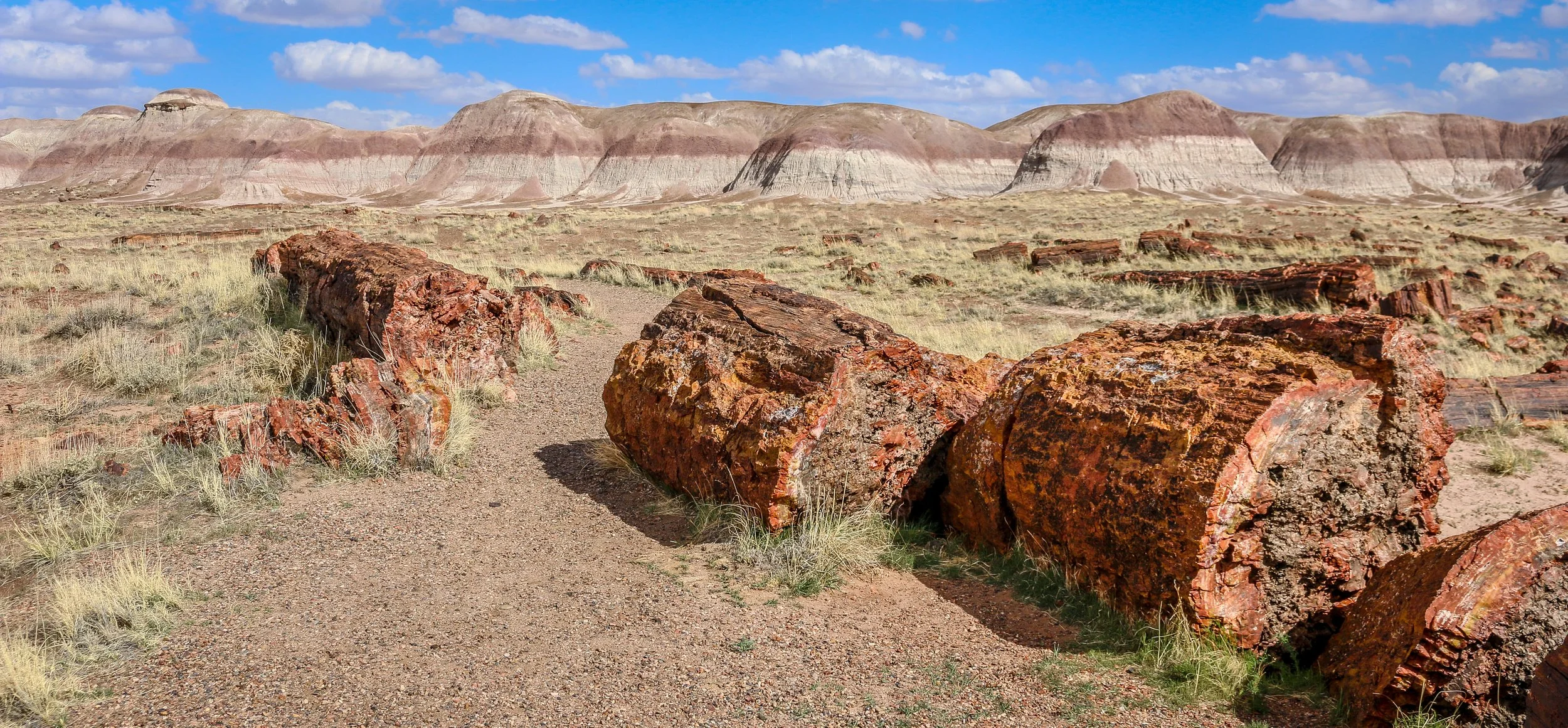
Petrified Forest National Park in eastern Arizona contains a beautiful collection of petrified wood and also includes the Painted Desert, Blue Mounds and an old stretch of Route 66. It’s a park best explored by car, but you won’t really appreciate it unless you get out and hike out into the wilderness. Petrified Forest was designated a National Monument back in 1906 and was upgraded to a National Park in 1962. I enjoyed my visit to the park and hope you enjoy these photos I took exploring the Petrified Forest.
After the Treaty of Guadalupe Hidalgo ended the Mexican-American War in 1848, New Mexico officially became a part of the United States. Americans started moving west to try and stake a claim in this new territory, but were often met with hostility by Indians trying to protect what they believed belonged to them. In response, the U.S. government built Fort Union at the main junction on the Santa Fe Trail. The original fort was good enough for that purpose, but a second, stronger, fort was built during the Civil War and a third fort soon replaced the second. The fort served two main purposes which were independent of each another - one being a military post and the other, a quartermaster depot. The depot was the supply hub for the government in the southwest and received hundreds of wagonloads of supplies daily to support 46 regional posts. There was also an arsenal on the base which could have also been seen as a separate entity as it had its own commander and staff. In addition, the base hospital provided the best medical care for hundreds of miles around. Fort Union served as the jumping-off point for Union forces on their way to fight at Glorieta Pass, the last Civil War battle fought in New Mexico. After the Civil War, African-American soldiers with the 57th U.S. Colored Infantry arrived at Fort Union and later the 9th U.S. Cavalry, remembered today as the Buffalo Soldiers, would join them. When trains started rumbling across the country at the end of the 19th century, Fort Union became obsolete and was decommissioned in 1891. The last soldiers left on May 15th of that year. In 1954, it became Fort Union National Monument and its history is now interpreted by the National Park Service.
Most of the fort was built of adobe which, without regular maintenance, will melt back into the desert. Some exceptions were the stone jail and the brick chimneys which provide a glimpse into what Fort Union once was. This park site doesn’t get many visitors, but it’s a fascinating place to learn about the Santa Fe Trail and early American history in the New Mexico Territory. I hope you enjoy these photos from fascinating Fort Union National Monument.