I absolutely love Joshua Trees. Much like the Saguaros are iconic to the Sonoran Desert, the Joshua Trees are iconic symbols of the Mojave Desert and it’s too easy to imagine human characteristics in both. Every time I pull into an area with Joshua Trees it makes me smile and feel happy. Interestingly, Joshua Trees aren’t really trees at all, but rather a tree-like member of the yucca family. They may have been given their name by early Mormon pioneers who thought they resembled the Biblical Joshua with his arms raised.
It is believed that people have been living in the region of Joshua Tree National Park for 10,000 years. The first people of European descent who laid eyes on the area were with Spaniard Pedro Fages who was pursuing Native Americans who had “escaped” the mission in San Diego. After the Mexican-American War, American settlers started moving in, building ranches and doing some small-scale mining. Franklin Roosevelt protected the area as Joshua Tree National Monument in 1936 and it became a National Park in 1994. The park covers 1,242 square miles - slightly larger than the state of Rhode Island.
I’ve visited Joshua Tree National Park several times before, but always in the middle of summer when it was boiling hot out. We might get out and take some photos, but long hikes were pretty much out of the question. I was really happy to get there this past spring when it was cool and pleasant and I could get out on the trails. I hiked the Short Loop Trail from Black Rock Campground, Ryan Mountain, and the Lost Horse Mine Loop among others and they were all fantastic. Joshua Tree National Park is a special place and while it doesn’t get the hype of our other western National Parks, it’s definitely worth a visit. I can’t wait to return. I hope you enjoy these photos from beautiful Joshua Tree National Park.
The Channel Islands are an eight island archipelago off the coast of Southern California and five of these islands make up Channel Islands National Park. The waters surrounding these islands are also protected as a National Marine Sanctuary. The Channel Islands were created by tectonic forces 5 million years ago and have always been islands, although they were closer to the mainland during the last ice age when the sea levels were lower. Because of their isolation, the islands are home to several endemic species of plants and animals meaning those found nowhere else on Earth.
People have inhabited these islands for a very long time. In fact the oldest human remains ever found in North America, dating back 13,000 years, were discovered on Santa Barbara Island in 1959. In more recent times, the northern islands were home to different bands of the Chumash people while the southern islands were inhabited by the Tongva. Juan Cabrillo observed the islands on his 1542 voyage up the coast and in more modern times the islands were used to raise sheep and cattle. They were protected as a National Park in 1980.
I was unfortunately only able to visit one of the islands in Channel Islands National Park during my stay, but Santa Cruz is the biggest and most accessible and made for a wonderful visit. I stayed in the campground at Scorpion Ranch for three nights and was able to hike to Cavern Point, Smuggler’s Cove, Potato Harbor and the incredible Montañon Ridge. For the last two days I was on the island, there were only 19 other people there which made for a peaceful and incredible stay. It was hard to believe that we were only an hour car ride and an hour ferry ride from the second largest city in the country, but it sure was nice to be there. I can’t wait to go back again. I hope you enjoy these photos from Channel Islands National Park.
The formations in Pinnacles National Park are thought to come from the western half of the Neenach Volcano which erupted 23 million years ago. Between then and now, this geologic formation is believed to have shifted almost 200 miles north and west thanks to plate tectonics.
This area was originally inhabited by the Ohlone people. Spanish missionaries established a mission at Soledad in 1791, just about 5 miles from the park’s current boundary. When American settlers moved into the area, they referred to the formations as “the Palisades”, and investors once considered putting a resort hotel at their base. The area was first protected as Pinnacles Forest Preserve in 1906 and then as Pinnacles National Monument in 1908. It became a National Park in 2013.
I had a great day in Pinnacles during my visit to the west side of the park. It had been raining for days and it was nice to see some blue sky for a change. I arrived early and was able to park in Bear Gulch, although there is a shuttle to bring people up from the Visitor Center as well. From there I hiked up the Condor Gulch Trail to the High Peaks Trail and then returned on the Bear Gulch Trail to the parking lot. It was a wonderful 6-7 mile loop through the pinnacles and provided great views in every direction.
The highlight of my day was definitely seeing the endangered California Condors which call the park home. I saw no fewer than 6 of them, which would be around 2% of the entire wild population of California Condors in the world. Some came so close I could’ve touched them if I’d have been sitting on your shoulders and I had never seen condors so close before. Watching them in flight is a truly special experience as they are enormous and cover a tremendous area in a short time. They move so quickly that they are tough to photograph, but there is one in the photo directly below. The condors alone were worth the visit, but I had aa awesome hike as well and it was reasonably quiet while I was there. While Pinnacles is one of the lesser known national parks in California, and for good reason, it is still a wonderful place to visit and worth a stop if you are in the area. I hope you enjoy these photos from Pinnacles National Park.
Organ Pipe Cactus National Monument was one of the top spots on my list of places to visit during my time in Arizona. It’s a remote park, located two hours from anywhere and right on the U.S./Mexican border, but it’s the only place in the country that you can find naturally occurring organ pipe cactus. In addition to these beauties, there are so many other species of cactus and desert plants as well which has led to this region also being named a part of UNESCO’s International Biosphere Reserve.
Organ Pipe Cactus was made a National Monument by Franklin Roosevelt back in 1937. A special act was passed to allow mining in the area during World War II, an act which sadly wasn’t repealed until 1976. The park’s remote location on the Mexican border used to bring both drug runners and human smugglers through the area, making this America’s most dangerous park. This danger is memorialized in the Kris Eggle Visitors Center which was named for a park ranger who was killed protecting visitors from drug smugglers in 2002. In the wake of his death, the border was reinforced and I felt safe there during my stay.
It was unbelievably hot when I arrived on an afternoon in late April. So hot that I couldn’t actually do anything but hover in the shade of the restroom and wait until the sun started to go down. I did enjoy a wonderful evening hike and an early morning one the following day as well. The area is beautiful and it was great to see the Organ Pipes in their native habitat. It was definitely just a one night stop, but I’m very glad I went. I hope you enjoy these photos from Organ Pipe Cactus National Monument.
There may be no more iconic plant in the United States than the stately and stoic saguaro cactus. These beautiful cacti can grow up to 40’ tall and live to be 150 years old. They won’t start growing arms until they are 75 years old and some will grow many arms in their lives. Most of the natural habitat of the saguaro is in the Sonoran Desert which straddles the U.S./Mexico border.
In 1933, President Herbert Hoover designated Saguaro National Monument which we now call the Rincon Mountain District of the park. In 1961, John F. Kennedy added the Tucson Mountain District to the Monument and in 1994 these two tracts were combined into Saguaro National Park.
Chiricahua National Monument in southeastern Arizona preserves a magical landscape created by a 27 million year old volcanic eruption. The lava hardened into rhyolite and erosion has carved out a wonderland of rock spires, balanced rocks and hoodoos. This little visited park site is truly spectacular and definitely worth a detour.
I arrived in the park late in the day so I didn’t have a ton of time to explore. After a quick stop at the Visitor Center, I made my way all the way up to Masai Point at the end of the 8 mile scenic drive and did the short nature loop there to get a good overview of the area. Then I set off on the magnificent 3.3 mile Echo Canyon/Hailstone/Ed Riggs loop trail which was really fantastic. When I finished this hike, the sun was on its way down and I enjoyed the glow on the rocks as I made my way back down the hill and on down the road.
While I was only in Chiricahua for a few hours, I really enjoyed my stay and look forward to returning again in the future. I hope you enjoy these photos from beautiful Chiricahua National Monument.
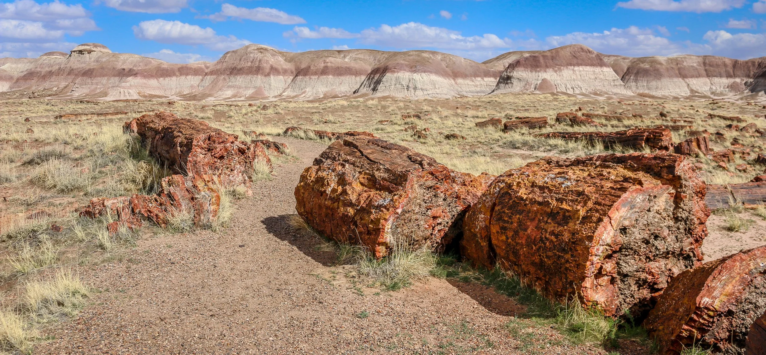
Petrified Forest National Park in eastern Arizona contains a beautiful collection of petrified wood and also includes the Painted Desert, Blue Mounds and an old stretch of Route 66. It’s a park best explored by car, but you won’t really appreciate it unless you get out and hike out into the wilderness. Petrified Forest was designated a National Monument back in 1906 and was upgraded to a National Park in 1962. I enjoyed my visit to the park and hope you enjoy these photos I took exploring the Petrified Forest.
Construction of the pueblo at Pecos was begun sometime in the 12th century. Over the next few hundred years it would grow to become one of the largest pueblos in the area, supporting a community of perhaps 3,000 people. Sitting in what is now eastern New Mexico, this agricultural community was also a trade center between the mountains to the west and the plains to the east. Francisco Vázquez de Coronado visited Pecos on his 1540 conquest, as did Don Juan de Oñate 60 years later when he ordered construction of a mission church to help convert the Puebloans to Catholicism. That church was destroyed during the Pueblo Revolt of 1680 and a smaller church would be built in its place when the Spanish returned to the area twelve years later. The spread of European diseases would bring the ultimate demise of Pecos and in the 1830s the last of its old residents made their way to Jemez Pueblo where their culture and tradition is still remembered in the oral history. Emigrants on the nearby Santa Fe Trail no doubt used Pecos as a campground and marveled at the old pueblo. General Kearny and his troops camped at Pecos as well on their westward journey to claim New Mexico for the United States. During the Civil War, the Confederate army was making their way through New Mexico on a quest for Colorado and California gold. Their troops turned back to Texas after being defeated at the Battle of Glorieta Pass which is right up the trail from Pecos. Tex Austin purchased the land in 1925 and turned it into the Forked Lightning Ranch which was purchased in 1941 by Buddy Fogelson. The Fogelsons were instrumental in creating Pecos National Monument in 1965, and after their deaths the park’s boundaries were expanded to include the ranch and the designation changed to Pecos National Historical Park.
Today the park does an incredible job of interpreting all of this fascinating history in its wonderful museum. The 1.5 mile trail takes you through the remains of the pueblo and into the ruins of the old mission church. Two kivas have been reconstructed to provide some insight into Puebloan culture and religion as well. It’s a beautiful place to visit and just a short drive from nearby Santa Fe. I hope you enjoy these few photos from fascinating Pecos national Historical Park.
Native Americans have been passing through the area we now call the Salinas Valley for thousands of years. As agricultural techniques developed, hunter-gatherer societies began to settle down, plant crops and build permanent communities. The communities which grew in the Salinas Valley combined the traditions of the people we call Mogollon with those of the Ancestral Puebloans. They traded with other Puebloan groups to the west and with the Plains Indians to their east.
When the Spanish arrived in 1540, Coronado was searching for the 7 Lost Cities of Gold. He never found gold, but found abundant salt deposits in these mountains which is where they get their name (“salinas” means “salt” in Spanish). While the treasure seekers were met with disappointment, the Franciscan priests who accompanied them found whole towns of souls they believed needed saving. They took up residence in these remote pueblos and oversaw the construction of massive churches. They brought with them items which changed these societies for the better like wheat, fruit, cattle, goats and sheep. They also brought disease and demands for the Native people to give up their rituals and traditions. Some of these pueblos contain kivas, the underground centers of Pueblo communities and religion which point to some level of compromise, since later missions had kivas filled in and destroyed. Spanish priests and governors were often in disagreement over how to treat the Puebloan people, and cultural conflicts would often erupt…
Magnificent White Sands National Park in central New Mexico preserves the largest gypsum dune field of its kind in the world. This dune field in the heart of the Tularosa Basin covers 145,762 acres and includes 4.5 billion tons of gypsum sand. This gypsum was left in the area after the Permean Sea retreated several million years ago, and water and wind shape the dunes we find there today. The dunes are ever changing, though, so you will never see the same landscapes on any two visits to the park.
People have been coming through the area for at least 11,000 years and we believe that a group we call the Jornada Mogollon were the first to farm the area (see my photos of their nearby petroglyph site here). Groups of Apache made their way into the area in the 1600s and European-Americans arrived in the 1800s. White Sands National Monument was created by Herbert Hoover in 1933 and it was made a National Park in 2019.
I arrived for my visit to the park just after dawn. The mountains to the east block the sunrise, but the skies were blue and full of amazing white clouds. I headed straight out to the heart of the dunes and hiked the wonderful 5 mile Alkali Flats Trail. The sun reflected brightly off the white sand making photography difficult, but I was grateful that there was no wind. In the late afternoon I set out to capture some of the beautiful plant life in the park, mainly different kinds of yucca, which contrast nicely with the white sand. I stayed to watch the sunset and found real peace and solitude out in the middle of the park. It was a wonderful day in White Sands National Park. You can find some of these photos for sale in my store , but please contact me if the one you want isn’t there and I’ll be happy to add it. I hope you enjoy these photos from my time in White Sands National Park.
Apostle Islands National Lakeshore is a beautiful park which stretches along Wisconsin’s Lake Superior coastline. The park extends over 21 of the 22 islands in the area with only Madeline Island being outside its boundary. In addition to the islands themselves, the park extends to the historic fishing area at Little Sand Bay and the beautiful coastline and sea caves at Myers Beach. Nobody is quite sure who gave the islands their names, but French maps referred to them as the Apostle Islands as early as the 1700s. The National Lakeshore was established in 1970, having been proposed by Wisconsin’s Senator Gaylord Nelson who is also considered the founder of Earth Day.
During my time in the park, I enjoyed a scenic cruise around the islands with Apostle Island Cruises. Our 2.5 hour journey took us around most of the islands with special attention paid to the beautiful, outer Devil’s Island and the historic lighthouse at Raspberry Island. Unfortunately, the islands were closed to camping during my stay so I wasn’t able to spend the night out there which I really would have enjoyed. Beyond the cruise, I spent some time learning about the history of the area at the outdoor museum at Little Sand Bay (which was also a wonderful place to watch the sunset). There were also recorded stories from rangers, historians and Native Americans in this section to listen to. On my last morning in the park I visited the Myers Beach section to hike the Lakeshore Trail to The Bowl to view the amazing sea caves and beautiful coastline. I was also pleasantly surprised by the number and variety of mushrooms I experienced along this trail. I had a wonderful visit to the Apostle Islands and hope you enjoy these photos from my stay.
The Ojibwa Indians called Isle Royale “Minong” meaning “a good place to be” and they certainly hit the nail on the head with that one. Isle Royale National Park consists of Isle Royale itself and over 400 smaller islands making up an archipelago in the middle of Lake Superior. Isle Royale is the largest natural island on Lake Superior and the second largest in the Great Lakes at 45 miles long and 9 miles wide. Some of Michigan’s earliest copper mines were established on Isle Royale in the 1840s, continuing the Ojibwa copper-mining tradition which stretched back hundreds of years. Commercial fishing operations also ran off of Isle Royale for many years, but it was the island’s beauty and ability to attract tourism which would create its lasting industry. Isle Royale National Park was established in 1940 and it was made a part of the UNESCO International Biosphere Reserve in 1980.
I had a wonderful 4 day/3 night visit to Isle Royale in the beginning of August. The island is only accessible by boat or plane, with ferries originating out of Houghton and Copper Harbor in Michigan and Grand Portage in Minnesota. I chose the Isle Royale Queen IV out of Copper Harbor which dropped me off in Rock Harbor on the island’s northeast side in about three and a half hours. After getting my backcountry permit from the ranger there, I headed off into the wilderness for the next three nights, staying at Daisy Farm, Lynn Cove and Three Mile campgrounds. I hiked about 25 miles during my time on Isle Royale and really found the island to be a beautiful place to be. After hiking all day, an afternoon dip in Lake Superior always felt great. I saw 9 moose during my visit and also a handful of beavers along with plenty of birds and toads. I really cherished my time on Isle Royale and hope you enjoy these photos from America’s least visited National Park.