Rio Grande del Norte is one of our more recent National Monuments, having been designated as such in 2013. It protects the confluence of the Red River and the Rio Grande which are both designated Wild and Scenic Rivers. Both gorges are gorgeous and the point of land above the confluence, called simply El Punto, provides amazing views from high above the two rivers. I hiked the Little Arsenic Trail while I was there, which brought me down to the Rio Grande and led me straight to the confluence. It was one of the better hikes I did during my stay in New Mexico and was very rewarding around every turn. I spent the night at the campground on the canyon rim and enjoyed a beautiful sunset in the evening and a magical sunrise the following morning. In between, the stars were spectacular. I debated whether to drive out to this park as it was somewhat out of the way, but I’m sure glad I did as it is stunning from end to end. If you’re ever in the area, you should as well. I hope you enjoy these photos from beautiful Rio Grande del Norte National Monument.
Shhh. This is one of the towns nobody wants me to tell you about. Red River is a stunning little ski town along the Enchanted Circle in Northern New Mexico. It looks a lot like a Colorado ski town, but smaller, quainter, cheaper and with that special New Mexico sense of enchantment. I was there on a beautiful spring morning when the sun was shining but the air was cool and crisp. Despite plenty of snow on the mountain, it was sadly closed for the season.
Native Americans have hunted up and down the Red River for centuries, but the town’s beginnings were as a mining camp in the late 19th century when gold, silver and copper were being pulled from the hills. The town boomed to a population of around 3000 by the turn of the century, and as the mineral deposits started to dwindle, Red River gained a reputation as a cool weather getaway and a trout fishing paradise.
Red River today has a year-round population of just around 500, but it will multiply many times over on winter weekends when the town is buzzing with vacationers. No matter where you are staying in town, you could probably walk to the slopes with the lifts taking off from right in the center of town. In the warmer months, the area is full of trails and fishing is still a major draw and the the high elevation makes it cooler than towns to the south, east and west. I loved my short stay in Red River and it is one of the towns that I will definitely be returning to in the future. I hope you enjoy these photos from Red River, New Mexico’s classic ski town.
The area that is now Tucumcari was once home to dinosaurs who walked the shores of an inland sea. When the water receded, the sediment formed into sandstone and one of the formations it left is now called Tucumcari Mountain (although it’s really more of a mesa). Prehistoric people tracked mammoths and mastodons in the area and later developed farming techniques and built villages. In the 18th century, the Apache and Comanche moved through the area, hunting bison and pronghorn. The name, Tucumcari, comes from an Apache word “tukanukaru,” meaning “to lie in wait for something to approach”. In the early 20th century, the Chicago, Rock Island and Union Pacific Railroad was making its way across the country and a tent city sprung up called Ragtown and, later, Six Shooter Siding. As the camp grew into a town, they changed the name to Tucumcari and it stuck. Route 66 came through in 1926 and the town became an overnight stop for people headed west. Signs for miles declared “Tucumcari Tonight” and people pushed through for the promise of a hot meal and a comfortable bed. Tucumcari today still capitalizes on nostalgia for the “Mother Road”, but also has a wonderful museum downtown which has a place for everything and everything has been lovingly put into place. I had a great stop in Tucumcari and definitely got my kicks on Route 66. I hope you enjoy these photos from beautiful Tucumcari, New Mexico.
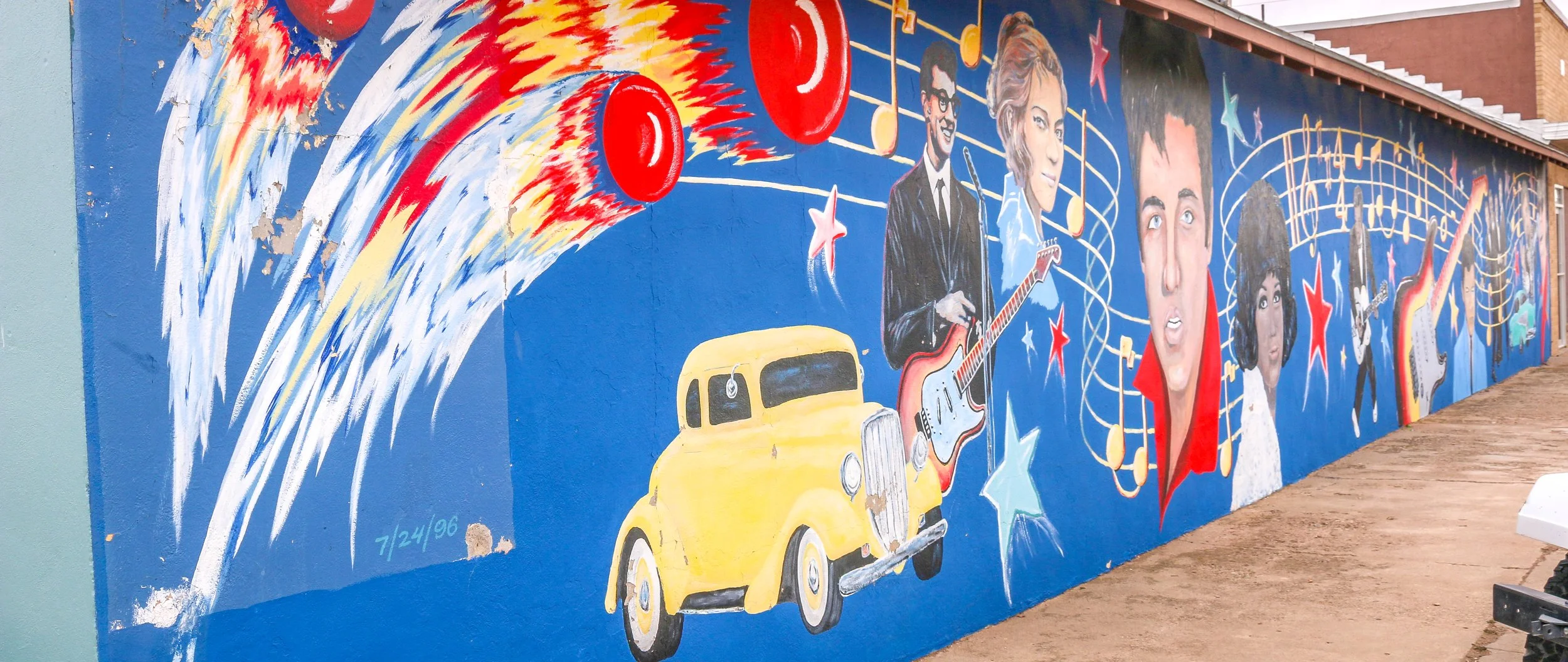
People have been in the Clovis area for at least 10,000 years as is evidenced by the “Clovis-man” finds at the nearby Blackwater Draw archaeological site. The town itself came much later, in 1906 in fact, when the Atchison Topeka and Santa Fe Railroad was making its way across the country. It’s the first town of any size you’ll find coming from Texas and the town has some Texas tendencies to be sure. It’s grown to a population of nearly 40,000 people and is the county seat of Curry County. For all it has to offer, it was a man named Norman Petty that brought me to Clovis. Petty started playing piano at an early age and in his mid-twenties had a hit record with his wife, Vi, and guitarist Jack Vaughn when they recorded the great DC born Duke Ellington’s Mood Indigo. The record’s success gave Norman enough money to open his own recording studio and in 1954 the Norman Petty Recording Studio was born. Petty recorded local artists and plenty from nearby Texas as well. In 1957, he produced a hit called Party Doll for Happy, Texas’ Buddy Knox. It was another Buddy though, Buddy Holly, who would really put Petty and Clovis on the music map. Norman would go on to produce records for Roy Orbison, Bobby Vee, The Fireballs and many others and their distinct style would be remembered as the Clovis Sound. I had a great time in Clovis and found a lot to like about it from its art deco buildings to its wonderful Vi and Norman Petty Museum. The downtown wind art was both beautiful and appropriate. Sadly it was cloudy for much of my visit, but it did manage to clear up right before I left so I did grab a few photos under sunny skies. Who knew New Mexico played such an important role in music history. If you’re ever in the area, stop in and check it out. I hope you enjoy these photos from musical Clovis, New Mexico.
After the Treaty of Guadalupe Hidalgo ended the Mexican-American War in 1848, New Mexico officially became a part of the United States. Americans started moving west to try and stake a claim in this new territory, but were often met with hostility by Indians trying to protect what they believed belonged to them. In response, the U.S. government built Fort Union at the main junction on the Santa Fe Trail. The original fort was good enough for that purpose, but a second, stronger, fort was built during the Civil War and a third fort soon replaced the second. The fort served two main purposes which were independent of each another - one being a military post and the other, a quartermaster depot. The depot was the supply hub for the government in the southwest and received hundreds of wagonloads of supplies daily to support 46 regional posts. There was also an arsenal on the base which could have also been seen as a separate entity as it had its own commander and staff. In addition, the base hospital provided the best medical care for hundreds of miles around. Fort Union served as the jumping-off point for Union forces on their way to fight at Glorieta Pass, the last Civil War battle fought in New Mexico. After the Civil War, African-American soldiers with the 57th U.S. Colored Infantry arrived at Fort Union and later the 9th U.S. Cavalry, remembered today as the Buffalo Soldiers, would join them. When trains started rumbling across the country at the end of the 19th century, Fort Union became obsolete and was decommissioned in 1891. The last soldiers left on May 15th of that year. In 1954, it became Fort Union National Monument and its history is now interpreted by the National Park Service.
Most of the fort was built of adobe which, without regular maintenance, will melt back into the desert. Some exceptions were the stone jail and the brick chimneys which provide a glimpse into what Fort Union once was. This park site doesn’t get many visitors, but it’s a fascinating place to learn about the Santa Fe Trail and early American history in the New Mexico Territory. I hope you enjoy these photos from fascinating Fort Union National Monument.
Hello Everyone! It’s been another amazing week out here in New Mexico and I can’t wait to tell you about it, but I’m going to start out this week with my most exciting news. As most of you know, I will be going back to my regular gig as an overland tour guide this summer. I’ll be working for a company called Incredible Adventures which is currently being run by my last two managers from my old company. I got a call from one of them yesterday with some thoughts on my start-up tour and I will be heading to Hawaii next month. Of all the places I thought I might go this summer, Hawaii was not on my list and I am so excited for this opportunity. It will be in the midst of my time in Arizona, but I will fly out and then back and be able to finish up my time there before heading on to San Francisco to begin my season in earnest. I am definitely looking forward to walking barefoot on a white sand beach and swimming in beautiful turquoise water. So with mai tais and sea turtles dancing in my head, let me tell you about my exciting week here in New Mexico.
When I left you last week, I was planning on heading to a place called Meow Wolf the following morning. Meow Wolf was an incredible experience which is really hard to explain. It’s essentially a big funhouse, full of fascinating and beautiful art installations. You enter it through the front door of a Victorian house and then you choose your own adventure from there. You can go through the fireplace into an ice cave with a mammoth skeleton which you can play like a xylophone. You can go through the refrigerator which takes you to a strange vacationland. You can go through the bookcase and come out in a circus-like room. You end up in treehouses and lighthouses and flying buses. It really is quite a place to experience and I was there for probably three hours and continued finding new rooms and passages right up until the end, and I’m sure I missed some along the way. It was weird and wonderful and I would definitely recommend it if you are ever in Santa Fe (or Denver or Las Vegas).
My Thursday afternoon was definitely one of ups and downs. I got a call from my dad telling me he had fallen and broken his ankle. He’ll be okay and is in a recovery facility, but I worry about some of these places and what floats around in them with Covid only being one such worry. On the flip-side, I got a nice email telling me one of my photos has been accepted to be published in a book of hiking trails from National Geographic called 100 Trails, 5000 Ideas. As a photographer, National Geographic is obviously one of the biggest names in the industry and while it will be a small photo in a big book, I’m still very happy to be included. In the afternoon I headed over to visit the Montezuma Masonic Lodge, where the gentleman I met in Taos told me I could find Kit Carson’s rifle. I met several of the Masons who were a part of the Lodge when I walked in, and they were incredibly warm and welcoming. The Secretary, Don, told me the whole story of the rifle and how Kit himself had instructed that it be hand delivered to the Lodge upon his death. It was, and they’ve been caring for it ever since. I had to put on a pair of gloves to hold it, but it was amazing to have this piece of history in my hands. I’m very grateful to the gentlemen of the Montezuma Lodge for their hospitality and all of the fascinating stories they shared with me while I was there. I decided to celebrate the day with a few beers at La Fonda, a wonderful must-see hotel right off the central Plaza in downtown Santa Fe. Mark has been bartending at La Fonda for years and it’s always a pleasure to stop in and say hello and have a drink in historic surroundings. From there, I said goodbye to Santa Fe and headed up the highway to the Buffalo Thunder casino for the night.
I started my day on Friday at Bandelier National Monument, not far up the road. Due to its proximity to Santa Fe it’s a busy park and it was fairly crowded when I was there, but there were some great old ruins to poke around at the base of some beautiful cliffs. When I had had my fill of the ruins, I had some lunch and then set off up the other side of the canyon on the Frijoles Rim Trail. It was a wonderful and beautiful trail and, in contrast to the valley, I didn’t see a single person along the whole hike. The trail took me up to the top of the canyon and along its rim for a mile or so and there were wonderful views down the canyon and off to the mountains in the distance. When I made it back to my van, we were off and running to Los Alamos to have a short look around Manhattan Project National Historical Park before it closed. I had been to another section of this park several years ago in Oak Ridge, Tennessee where they had enriched the uranium which was then transported to Los Alamos and built into the atomic bombs. They tested their first bomb at the Trinity Site down near what is now White Sands National Park…
“The Original Las Vegas” was founded along the Galinas River in 1835 in the midst of Mexican rule in the area and quickly grew as a popular stop on the Santa Fe Trail. It was on the Plaza in Las Vegas where Stephen Watts Kearny claimed New Mexico for the United States during the Mexican-American War in 1846. In 1879, the Atchison, Topeka and Santa Fe Railroad came to Las Vegas and the town quickly grew into one of the largest in the region. The New Mexico Normal School (now Highlands University) was established in 1893 and Fred Harvey built the Castañeda Hotel in 1898 as part of his hospitality empire in the southwest. Las Vegas hosted Teddy Roosevelt’s Rough Riders’ first reunion in 1899, a tradition that continued for many years. In more recent years, Las Vegas has been the filming location for many movies including No Country For Old Men, Wyatt Earp (with Kevin Costner), and perhaps most notably for me, Red Dawn where it served as the fictional town of Calamut (the massive “Calamut Says Howdy” mural is still a prominent feature downtown). I found Las Vegas to be a quiet, charming University town with some spectacular architecture, fascinating history and friendly people. It may be the “other Las Vegas”, but it’s a town not to be missed on your travels in New Mexico. I hope you enjoy these photos from wonderful Las Vegas, New Mexico.
Hello Everyone! It’s been a wildlife viewing week out here on the roads of Northern New Mexico. I’ve seen eagles and hawks in the air, deer, bighorn sheep and pronghorns in the fields and lots of prairie dogs running around searching for their underground tunnels. I like seeing wildlife. These animals make me smile. I’ve actually done a lot of smiling this week as I’ve found myself in wild places surrounded by beautiful landscapes and breathtaking sunrises and sunsets. I’ve managed to keep most of the demons in my head at bay this week and have felt pretty good all around. The weather has generally been great this week as well which hasn’t hurt. Warm, sunny days and cool, pleasant nights work really well for me. I do find that I need to change from shorts to long pants very soon after the sun goes down – it doesn’t take long to cool down in this dry air. It’s hard to believe I’ve been in New Mexico for over a month at this point, but I’m starting to make plans for the final stretch of my time here and then I’m off to Arizona for the rest of my winter/spring. My month in New Mexico has been special and memorable and I definitely understand why they call it The Land of Enchantment.
When I left you last week, I was in tiny Clayton, New Mexico in the far northeast of the state. I did head out to Clayton Lake State Park that evening which has a fascinating “pad” of over 200 dinosaur footprints from when the area was the muddy shoreline of a vast inland sea. Some of the footprints were very pronounced in the evening light and while it was very windy out there it was still really cool to see. I decided to spend the night at one of the campgrounds by the lake and ended up having the whole place to myself which was really nice. It was windy and cold, but I stayed out to watch the sunset and then popped out periodically to check out the stars which were really bright and mesmerizing.
Thursday morning I stuck around my campsite for a bit, enjoying my coffee and the warm sun on my face by the lake. I’ve been rereading the book Blood and Thunder by Hampton Sides which essentially tells the history of early American New Mexico. It’s an excellent book, and I’m enjoying it even more now that I’ve been to a lot of the places he writes about. A pair of bald eagles were cruising around the lake while I read which was awesome. Eventually I pulled up stakes and headed back into town to take a few more photos and then got on the road west to Capulin Volcano National Monument. I had noticed on my way out to Clayton Lake the evening before that the landscape was much more volcanic in that part of the state and it became even more pronounced as I went west. I drove past Sierra Grande, which is an incredible example of a shield volcano and then headed towards Capulin which is one of the country’s best specimens of a cinder cone volcano. This volatile and quick-forming volcano (which looks like what you imagine in your head when you think of a volcano) formed sometime around 60,000 years ago. The fertile soil it produced made for some fine grazing land so ranchers have used the land around the volcano for centuries and its distinct and easily recognizable shape made it a landmark on the Santa Fe Trail. Today, you can drive right to the top which is pretty cool but probably not for the faint of heart as there is a pretty severe drop-off and not many guardrails on the road. Once you get up there, though, you are rewarded with remarkable views in all directions and you can hike around the rim and down into the crater. You can look east at the seemingly endless plains stretching to the horizon and west to where they run into the Rocky Mountains. When I left the park, I headed north to Folsom and planned on taking the road over Johnson Mesa to Raton so I could drive past the Folsom Man Site, an archaeological area similar to the Clovis Man Site I talked about last week when I visited the Blackwater Draw museum. Somehow I took a wrong turn and ended up going a half hour down the wrong road but it was a beautiful road and a nice detour. When I finally figured out I had gone astray, I returned to Folsom and found the road I wanted to take. It was poorly marked and when I made the turn, I found it was also closed. Two hours later, I was back at Capulin but thankfully it was only a short drive from there to Raton. Raton is a cute little town on the railroad line with an old theatre and an older train station. I did wander around town a little bit but I was pretty tired and didn’t find out much about it. I stopped in for a great craft beer and one of the best burritos I’ve ever had at the Cellar Brewery (which is actually on the first floor, but they brew the beer in the basement) and then called it a night.
On Friday morning I headed just down the road to the town of Cimarron. Their sign reads “Where the Plains Meet the Mountains” and you can look west from town and see the Rockies emerging from the flat plains. Cimarron is also home to the Philmont Scout Ranch, a massive wilderness area donated by oilman Waite Phillips to the Boy Scouts in 1938. Way back in 1992, I came to Philmont on my very first trip to New Mexico and my first trip anywhere west of the Mississippi. My Boy Scout troop spent 10 days backpacking through the Sangre de Cristo Mountains and covered about a hundred miles on foot if my memory serves. It was an amazing experience for a city kid like me and a formative one…
Native Americans mined turquoise in the hills which now surround the tiny town of Cerillos. In more recent times, miners have also found gold, silver, copper, lead and coal in the area. An early Spanish explorer commented on the mineral wealth in these “little hills”, which gave the town its name. While all of the things that are mined in the area are valuable, it was the 1879 discovery of gold which really put Cerillos on the map. The railroad came through the following year and the town boomed. The town’s population grew to over 3,000 and it supported 21 saloons, 4 hotels, 3 churches, an opera house and several newspapers. At one point, Cerillos was even in consideration to be the capital of New Mexico and was visited by Teddy Roosevelt. With every boom comes a bust and by 1930 most of the big mines had closed, although turquoise is still mined nearby and is considered some of the finest in the country. The dirt roads and old buildings of Cerillos have made it a great Western filming location with Walt Disney's Nine Lives of Elfego Baca and Young Guns being two of Cerillos’ most famous productions. I’ve probably seen Young Guns several dozen times, so Cerillos felt familiar as I walked the streets and when I saw the faded Murphy-Dolan Store sign on the side of the old Wortley Hotel it really made me smile. Cerillos is a great little turn-off from the Turquoise Trail Scenic Byway which connects Albuquerque and Santa Fe and I definitely enjoyed my visit. I hope you enjoy these photos from the old mining town of Cerillos.
Madrid was the first town I came to along the beautiful Turquoise Trail, the scenic byway which connects Albuquerque and Santa Fe. Pronounced MAD-rid for some maddening reason, I couldn’t find a clear story as to how the town got its name. The earliest Europeans in the area most likely came from Spain, but it doesn’t appear that Madrid got its name until New Mexico was an American territory. First lead and then coal were mined in the surrounding hills and in 1892 a 6 mile spur was built to connect the town to the Santa Fe Railway. By 1906, coal mining in the area was consolidated under the Albuquerque and Cerrillos Coal Company and a company town grew to a population of over 3,000, more than that of Albuquerque at the time. In 1922, Madrid boasted the only baseball field with lights west of the Mississippi River, and the Brooklyn Dodgers’ minor league affiliate the Madrid Miners played there for many years. The mines did well until the early 1950s and in 1954 the Coal Company left Madrid and many of the residents went with them. By the early 1970s, Madrid was almost a ghost town but then artists discovered the town and started moving in. Today, Madrid is a vibrant and colorful town with many reminders of the old mining town that it once was, but truly reborn as an artists’ colony and a tourism destination. I hope you enjoy these photos from beautiful Madrid, New Mexico.
Native Americans have been passing through the area we now call the Salinas Valley for thousands of years. As agricultural techniques developed, hunter-gatherer societies began to settle down, plant crops and build permanent communities. The communities which grew in the Salinas Valley combined the traditions of the people we call Mogollon with those of the Ancestral Puebloans. They traded with other Puebloan groups to the west and with the Plains Indians to their east.
When the Spanish arrived in 1540, Coronado was searching for the 7 Lost Cities of Gold. He never found gold, but found abundant salt deposits in these mountains which is where they get their name (“salinas” means “salt” in Spanish). While the treasure seekers were met with disappointment, the Franciscan priests who accompanied them found whole towns of souls they believed needed saving. They took up residence in these remote pueblos and oversaw the construction of massive churches. They brought with them items which changed these societies for the better like wheat, fruit, cattle, goats and sheep. They also brought disease and demands for the Native people to give up their rituals and traditions. Some of these pueblos contain kivas, the underground centers of Pueblo communities and religion which point to some level of compromise, since later missions had kivas filled in and destroyed. Spanish priests and governors were often in disagreement over how to treat the Puebloan people, and cultural conflicts would often erupt…
In 1598, Juan de Oñate y Salazar was on a conquest to colonize Nuevo Mexico for Spain. Traveling north of El Camino Real, his caravan had just passed through the dreaded 90 mile stretch known as the Journada del Muerto or “Journey of the Dead Man” when they encountered the Piro people of the Tempana Pueblo. These people offered the party food and water and Oñate called the place “Socorro” meaning succor or aid. In 1626, the Spanish built a mission church nearby and christened it Nuestra Señora del Perpetuo Socorro or Our Lady of Perpetual Succor. The mission was abandoned and destroyed during the Pueblo Revolt of 1680 and wouldn’t be resettled until 1815. A beautiful new church was built and named after San Miguel.
I came to Socorro because it was where I was when I ran out of steam for the day. It was on my radar, but I didn’t know if I would have time to stop. I’m sure glad I did. There are so many wonderful historic buildings around town, and the evening was absolutely perfect for photography. I enjoyed a nice long walk around downtown and then settled into the mining-era Capitol Bar for a couple of their house-brewed beers. Then I ventured out to El Camino Restaurant and Lounge, a holdover from another time. Both the restaurant and the lounge are worth visiting for the ambiance alone. It snowed overnight and while there wasn’t much on the ground, the mountains had a lovely dusting. I happily snapped a few more shots with the snow before hitting the road. Socorro is definitely worth a stop on your way through New Mexico and I hope you enjoy these photos from my brief time in this wonderful little town.